1. A notebook too small for the handwriting
Augie had packed a pencil, a blue crayon and a very small eraser for their next mystery.
“If the ice writes on stone,” he said, “I want to see its pencil.”
The family had arrived near Seward, Alaska, to explore Kenai Fjords National Park. Mountains rose above coastal water, and snow and ice held bright places between the peaks. After the warm shores of Virgin Islands National Park, the children checked their jackets twice.
“The ocean changed its outfit,” Andy announced.
Allie opened their notebook. Their last adventure had followed connections among reefs, rooted seagrass, mangroves and island land. Here, another set of connections reached from mountain snow toward the sea.
Their new question filled the top of a page: How can moving ice leave a message in solid rock?
Ana drew three empty boxes beneath it. “What makes the ice move? What tools does it carry? What happens after it passes?”
Their grown-up had chosen a suitable visit in the Exit Glacier area, with park information and photographs for the distant icefield and coastal fjords. The children would not climb onto a glacier or paddle toward a wall of ice. A good investigation could combine safe observations with views recorded by other people.
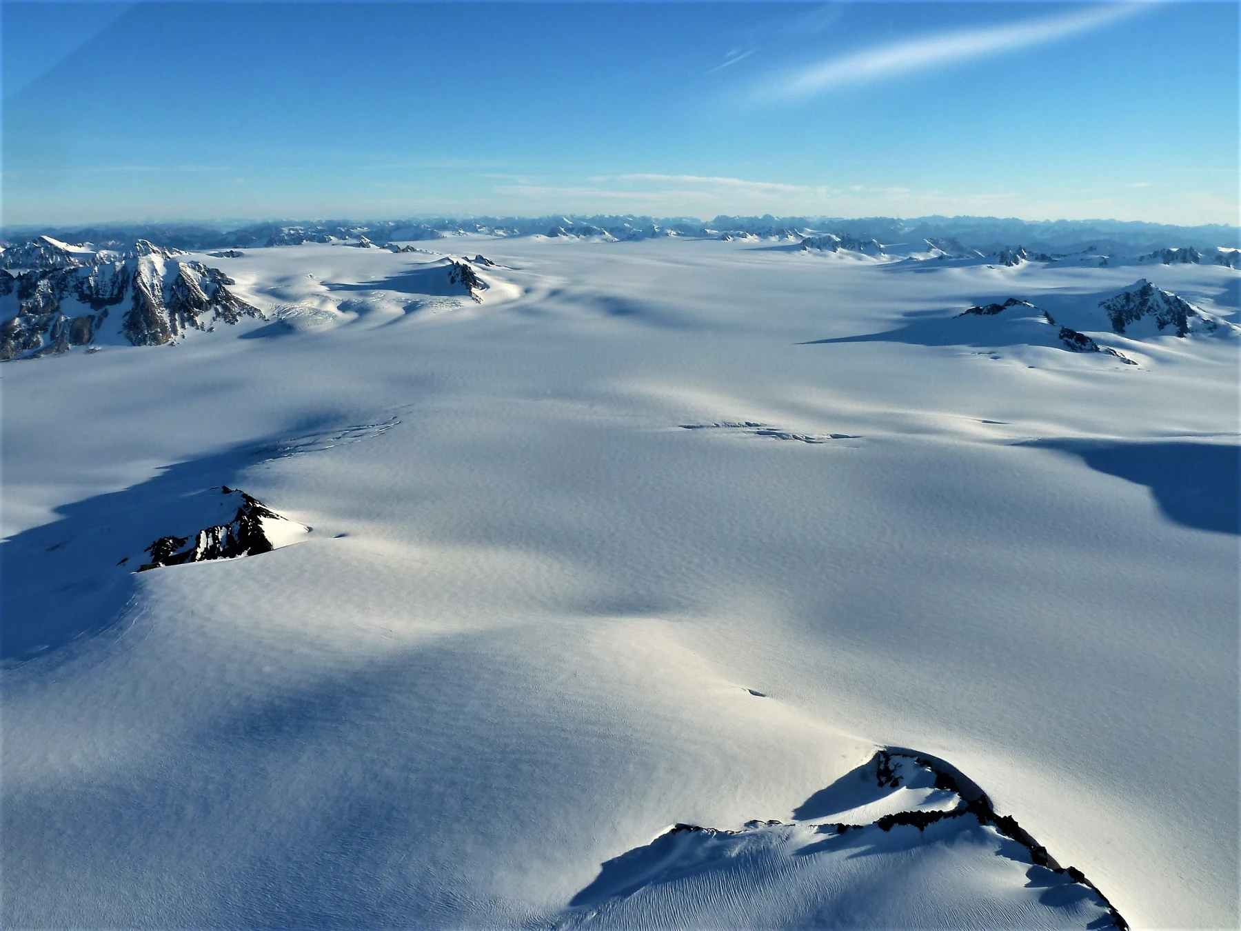
Augie studied a photograph of the Harding Icefield, where mountains poked through a broad expanse of white.
“The freezer forgot its walls.”
“Or our notebook forgot to be mountain-sized,” Andy said.
Allie wrote a smaller promise beneath the big question: find the evidence, then explain it.
Ana tapped Augie’s eraser. “We may need that if our first explanation is wrong.”
He put it in the middle of the notebook, ready for scientific emergencies.
2. A snowflake joins a very slow river
At first, Andy pictured a glacier as a giant ice cube parked on a slope.
“If it’s frozen,” he asked, “why doesn’t it just sit there?”
The children used park information to build the story from the beginning. Snow accumulated where enough could survive from one year to the next. Later snow buried earlier layers. Over time, the snow changed, compacted and became denser ice.
Allie drew a stack of snowflakes with an arrow pointing toward glacial ice.
“Not one cold afternoon,” she said. “A long process.”
“And not every snowy hill becomes a glacier,” Ana added.
A thick body of glacier ice could flow under its own weight. Gravity provided the pull; the ice could deform internally, and movement could also happen at its base. It did not need to melt into a liquid river before moving.
Augie looked doubtful. His freezer ice cubes had never marched out of their tray.
“The size, pressure and time matter,” Allie explained. “A little cube on a kitchen counter doesn’t show us everything a glacier can do.”
Andy drew a river arrow through a block of ice, then crossed out the wavy liquid lines.
“Solid ice, moving slowly. My drawing needs better labels.”
Ana liked that answer. They had often used familiar objects to begin a mystery. The next step was noticing where the comparison stopped helping.
Through a photograph, they followed the Harding Icefield toward glaciers leaving the mountains in different directions. The icefield connected those icy streams; mountain peaks could remain exposed above it.
“An ice octopus,” Augie declared. “With very patient arms.”
Allie wrote the real terms beside his drawing: icefield and outlet glacier.
Exit Glacier was one of those outlets. The white country in the photograph was not separate from the valley they were learning to read. It was part of the same moving system.
3. The ice borrows tools from the mountain
Ana returned to the question about handwriting.
“Soft-looking snow turns into ice. But the bedrock is hard. What actually makes the scratches?”
The answer involved passengers.
Rock fragments and sediment carried at the bottom of a glacier could grind against the bedrock beneath it. That wearing and scraping was called abrasion. The glacier’s load helped it work like an enormous, slow piece of rough sandpaper.
Augie drew tiny boots on the ice.
“Sandpaper shoes.”
“Useful picture,” Allie said. “But let’s label the rock fragments. The tools are important.”
The children examined a park photograph of striations: scratches and grooves left on rock. Several marks ran in a similar direction. Their grown-up reminded them to study surfaces from the established route rather than scramble toward the glacier to find a better example.
“What would make this evidence stronger than one random scratch?” Andy asked.
Ana pointed to the pattern. They could consider several aligned marks, the surrounding glacial landscape and the park’s interpretation together. One line alone did not explain the whole history of a stone.
Glaciers also removed larger pieces. Existing cracks in bedrock could widen and join, allowing blocks to break away and be carried by the ice. That process was called plucking.
“So abrasion wears material down,” Allie said, “and plucking takes pieces away.”
Andy drew two imaginary job cards. One said SCRAPE. The other said LIFT AND CARRY.
“Mountain remodeling crew.”
Augie reached for his eraser, then stopped. “Can the mountain ask for its pieces back?”
“Some will end up somewhere else,” Ana said. “We need to follow the load.”
Their mystery had gained a useful sequence: moving ice, rock tools, altered bedrock. The glacier did not need a pencil. It brought a workshop.
4. Travel receipts made of rock
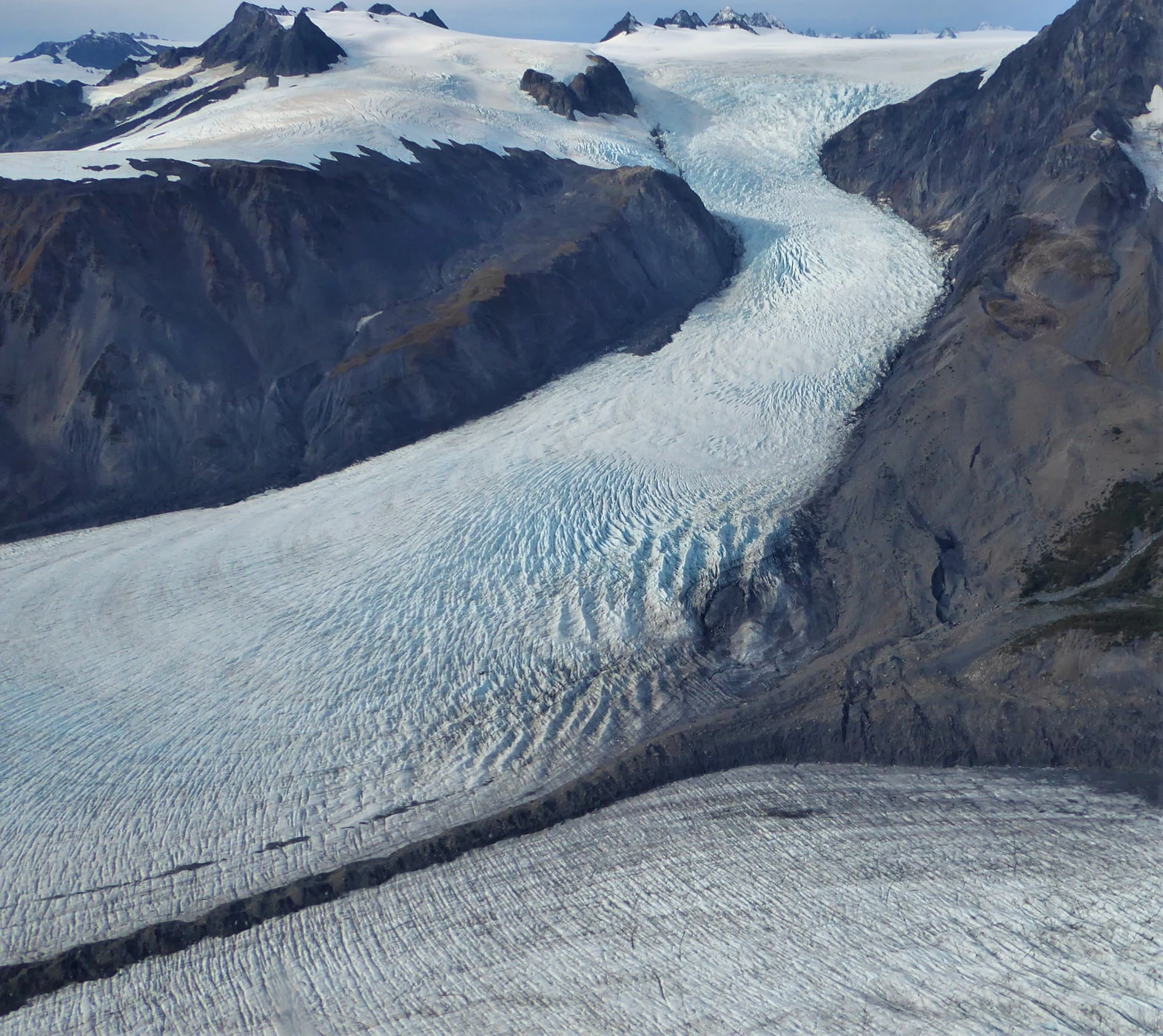
Aerial photographs gave the family a view they could never get from their walking route. On Bear Glacier, dark bands stretched along a pale surface between the mountains.
“Racing stripes?” Andy suggested.
“Travel receipts,” Allie replied. “The ice has collected things along the way.”
Rock debris could gather along the sides of a glacier. When glacier streams joined, debris from their adjoining sides could form a stripe down the combined flow. Such a band was called a medial moraine. Other bands could begin below rock outcrops surrounded by ice.
Ana traced a possible route with a finger above the photograph, without touching the page.
“Let’s follow where a stripe starts before saying how it formed.”
The dark line was material carried by ice, not a road painted onto it. Its position was another clue about the glacier’s journey.
Eventually, melting released some of the load. Deposits could include a mixture of particle sizes; meltwater could pick material up again, move it and sort it differently. Erosion, transport and deposition were connected parts of the story.
Andy made three notebook columns: remove, carry, leave behind.
Augie added a fourth: unpack snacks.
“That’s our process,” Ana said. “The glacier has a different one.”
Fine sediment could make meltwater look cloudy. They found the term rock flour for tiny ground-up particles. It was not flour for baking, and cloudy glacier water was not a drink to sample.
Allie imagined a rock fragment moving through several chapters: broken from bedrock, carried in ice, released near an edge and carried farther by flowing water.
“The glacier’s work doesn’t always stop where its ice stops.”
Ana drew the arrow beyond the glacier’s end. That arrow would matter when their investigation reached the sea.
5. The ocean moves into an old valley
The children sketched two valley cross-sections. Andy made a narrow V. Ana made a wider U with steep sides.
“A river often cuts a valley with a V-shaped cross-section,” Allie explained. “A valley glacier can widen and deepen its route, leaving a broad floor and steep walls.”
They remembered Yosemite and other mountain landscapes from earlier adventures. Here, the same general clue helped explain the coast.
A fjord was a glacially carved coastal valley filled by seawater. Its floor lay below sea level, with the water occupying space where ice had once been.
“The ocean moved into the glacier’s old apartment,” Augie said.
Andy added a welcome mat to the sketch. “Very tall walls. Excellent water view.”
The real valley was much more complicated than a letter U. Rock type, fractures, repeated glaciations and other processes helped shape landscapes. Their drawing showed a useful pattern, not an exact outline for every inlet.
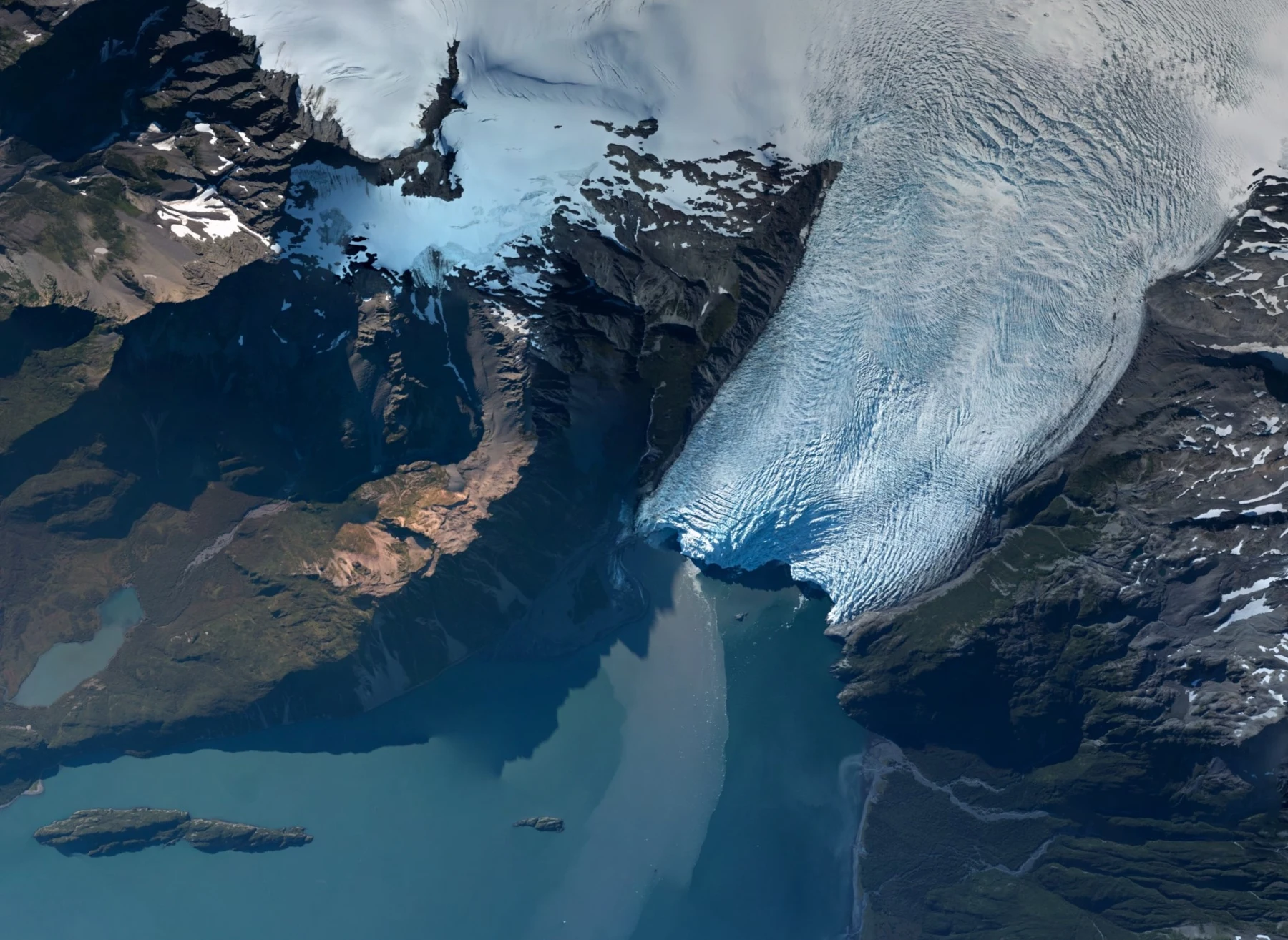
They studied an aerial view of Aialik Glacier and the coastal water below it. Allie traced from the mountain ice toward the glacier’s lower end. Ana traced the water in the opposite direction, into the valley.
“The glacier explains the carving,” Ana said. “The sea explains what fills the carved space.”
Not every bay was a fjord, and not every glacier reached the ocean. Exit Glacier ended on land. A tidewater glacier ended in seawater. The names described different relationships between ice and its surroundings.
Andy looked back at their first page. The icefield, the glacier and the fjord had seemed like three enormous separate subjects. Now arrows joined them.
Augie measured his notebook with both hands.
“The handwriting still doesn’t fit.”
“The explanation does,” Allie said. “We just need more than one page.”
6. A crack is not an invitation to come closer
In park media, the family watched ice break away from the front of a tidewater glacier. A piece fell into the water, followed by spreading waves.
The process was called calving.
“No baby cows?” Augie asked.
“Different meaning,” Andy said. “Much colder nursery.”
The children were watching recorded footage, not waiting below the ice face. That distinction mattered. Falling ice could displace water, and waves could reach boats or shorelines. An exciting photograph did not tell a visitor where it was safe to stand or paddle.
Allie wrote: A good view does not require a close approach.
Their grown-up explained that actual boat trips depended on conditions, experienced operators and current park guidance. Cold water, changing weather and glacial hazards were part of planning. The family’s short land visit was enough for this investigation; distant subjects could come to them through interpretation.
Ana noticed another useful difference. Calving was the breaking of ice from a glacier’s end. Melting was a change from solid ice to liquid water. Both could remove ice, but they were not the same event.
Andy made two arrows from a glacier drawing: one toward liquid water, another toward a floating piece of ice.
“If we label everything ‘melting,’ we miss part of the story.”
Augie added an arrow toward a person with binoculars, well away from the danger.
“This explorer uses the zoom.”
Allie liked that arrow most. Careful observation included decisions about distance. The children could be curious about how a glacier worked without treating an unstable edge like a playground.
They closed the video and checked their diagram. The carving, the carrying, the breaking and the melting each had its own place.
7. The edge can retreat while the ice keeps moving
Near Exit Glacier, park interpretation helped the family think about where the ice edge had been at different times. Their grown-up kept everyone on the appropriate open route. They did not use an old photograph as a map to the present ice.
Andy frowned at a sequence of glacier images.
“If the edge moves uphill, does all the ice run backward?”
Ana drew a conveyor belt carrying blocks toward one end of a table. Then she erased the final blocks faster than Andy could draw replacements.
“The belt can keep moving this way,” she said, “while the place where the blocks end shifts back.”
Glacier retreat described a change in the position of the terminus, or end. Ice could continue flowing toward that end while losses outpaced the ice arriving there. Tracking the edge and tracking the motion of individual ice were different measurements.
“That’s a sneaky arrow problem,” Andy said.
Scientists used repeat photographs, maps and other measurements to document change. Comparing images worked best when dates, viewpoints and recognizable landmarks were known. A close-up from one year and a distant view from another could be misleading without context.
Allie added a scientist’s question beneath each pair: What was measured, and what stayed comparable?
Changes in temperature and snowfall affected glaciers, while local shape and conditions also mattered. One rainy afternoon was weather; understanding a changing glacier required records across time.
Augie wanted to draw a sad face on the shrinking ice.
“We can care about it,” Ana said, “and still look carefully at the evidence.”
He drew the face in the margin and left the measurement space clear.
Their notebook now held both feelings and observations, with labels helping them tell the difference.
8. A coast with residents and a living history
A glacier might look like the main character in every photograph, but the surrounding water was habitat.
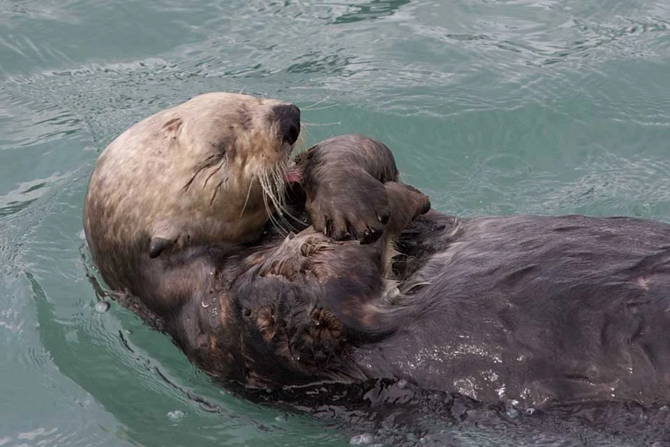
The children examined a sea-otter photograph from the park’s monitoring work. The animal floated on its back, busy grooming.
“Checking its coat?” Augie asked.
“Keeping that dense fur in good condition,” Allie said. “Sea otters rely on their fur and the air it traps for insulation.”
Ana connected another set of arrows. Sea otters ate animals including sea urchins. Urchins grazed on kelp. In some coastal communities, otters could help limit that grazing pressure. The relationship did not mean every bay had exactly the same balance.
Andy drew an otter beside the glacier diagram.
“It doesn’t carve the valley,” he said. “But it belongs in the story of what lives here.”
The family also read about the Sugpiaq, also known as Alutiiq, people and their enduring connections with the coast. Generations had known this region through travel, food, skilled work, language and community. This was a homeland with living relationships, not an empty landscape waiting for visitors to discover it.
Allie wrote the names carefully. “We should learn from people’s own accounts and the park’s work with communities.”
Ana left room for questions rather than inventing a traditional story or pretending their short visit gave them that knowledge.
Augie added a little house beside the word home.
Their first drawing had shown only ice and stone. The fuller page included marine life and people, each with its own connections. Physical geography helped explain the setting; it was not the whole meaning of the place.
Before leaving, the children checked for dropped wrappers and kept their observations in the notebook. Rocks, plants and historic objects belonged where they were.
9. Reading the big letters
Back with their notebook, Allie asked everyone to explain one piece of the mystery without borrowing somebody else’s answer.
Ana started with the snow. “Enough survives, gets buried and changes into denser ice. A glacier can flow under its own weight.”
Andy picked the tools. “Rock debris carried by ice can grind bedrock. Cracked blocks can be removed too. The glacier carries what it picks up.”
Augie chose the coastline. “The ice makes a big valley. If the coastal valley is below sea level and seawater fills it, that’s a fjord.”
He pronounced fjord carefully, then gave the word an enormous underline.
Allie finished with evidence. “Scratches, valley shapes, debris and repeated measurements help us work out what happened. We should connect more than one clue.”
Their grown-up asked about the question still written on the first page: how could moving ice leave a message in solid rock?
The four children built an answer together. Ice moved, carried rock tools, wore and removed bedrock, transported debris and left material behind. Over long periods, that work could reshape whole valleys. At the coast, the sea could fill a glacially carved valley and make a fjord.
“The ice writes slowly,” Andy said, “but the letters are enormous.”
“And not all the pages are finished,” Ana added.
Glaciers changed. Coastal habitats changed. People continued to study, care for and live in relation to the region. Their notebook was a record of an investigation, not the last word on a living place.
Allie wrote the next destination: Great Basin National Park, where another water mystery waited in Nevada.
Augie packed his pencil and unused little eraser.
“Next time,” he said, “I’m bringing a bigger notebook.”
Explorer’s notebook
Nine discoveries to keep
- A glacier begins with snow that survives, accumulates and changes into denser ice over time.
- Glacier ice can flow under its own weight; it does not have to become a liquid river first.
- The Harding Icefield connects glaciers that flow outward through the mountains.
- Abrasion grinds bedrock with carried debris; plucking removes blocks of rock.
- Glaciers transport sediment and can leave deposits such as moraines as ice melts.
- A fjord is a glacially carved coastal valley filled with seawater.
- Calving breaks ice from a glacier; melting turns solid ice into liquid water.
- A glacier’s terminus can retreat even while ice continues flowing toward it.
- Kenai Fjords holds coastal habitats and enduring Sugpiaq/Alutiiq connections as well as a geological story.
Five family adventures
- Make a scratch-clue model. With a grown-up, spread a thin layer of modeling clay in a washable tray. Slide a smooth craft block over one patch; attach a thin clay pad with a little clean sand to its underside and slide it over another. Compare marks using similar pressure. This models debris abrasion, not glacier flow, plucking or rock strength. Keep sand away from eyes and clean the tray afterward.
- Build a valley cross-section. Shape two small valleys in clay, one narrow and V-like, one broad and U-like. Draw the view from across each valley. Add blue paper inside the coastal U-shaped example and explain what else must be true for it to represent a fjord. The model shows a shape and water level; it does not reproduce thousands of years of erosion.
- Trace a rock’s journey. Draw five panels: cracked bedrock, a fragment carried by ice, a debris band, release during melting and movement by meltwater. Label erosion, transport and deposition where they apply. Give the fragment a funny travel diary, but keep the scientific arrows accurate.
- Test the retreat puzzle. On a table, move a strip of paper with drawn ice blocks toward an end marker. In successive drawings, cross out end blocks faster than new blocks arrive. Show how the surviving edge shifts back while the paper moves forward. Then explain the model’s limit: real glaciers deform, gain and lose ice in complex ways.
- Become a repeat-photo detective. Photograph a safe home scene from a marked spot on two different days, without including private information or other people. Match the framing and identify what changed. Record dates and one thing the pictures cannot tell you. Use a growing plant or rearranged objects; never approach a glacier or stream for this activity.
Four questions for the road
- Why can rock fragments at the bottom of a glacier help it scratch other rock?
- How does a fjord differ from just any bay or inlet?
- How can ice keep flowing toward a glacier’s end while that end retreats?
- What would you want to know before using two photographs as evidence of landscape change?
Eight words for your explorer kit
- Glacier: A body of ice formed on land that flows, or shows evidence of flow, under its own weight.
- Icefield: An extensive area of interconnected glaciers, with some mountain peaks potentially exposed.
- Abrasion: Wearing away a surface by grinding or scraping; glacier debris can abrade bedrock.
- Plucking: Removal of blocks from fractured bedrock by glacial action.
- Moraine: An accumulation of debris deposited or carried by a glacier.
- Fjord: A seawater-filled coastal valley carved by glacial erosion.
- Calving: Breaking of ice pieces from the end of a glacier.
- Terminus: The end or lower edge of a glacier.