1. The wet post office opens
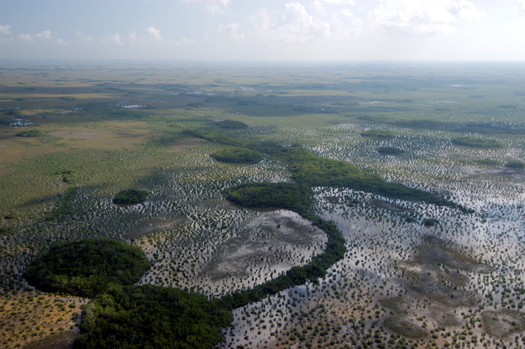
At Joshua Tree, Augie had drawn a mailbox on long legs for their next destination. Now Allie wrote EVERGLADES NATIONAL PARK above it, and Andy added a sign: PLEASE KEEP THE LETTERS DRY.
Ana studied their new photograph. Water shone between tall plants, with trees gathered in patches beneath an enormous sky.
“Florida,” she said. “A very different water problem from the desert.”
Andy remembered all the careful water saving in their last chapter.
“Someone definitely opened the big tap.”
Mom and Dad had planned short outings, boardwalks, exhibits, and time to rest. They checked weather and current park conditions, packed drinking water and sun protection, and brought appropriate protection against biting insects. Their first walk would keep everyone on an established route, together and away from wildlife.
From a viewing place, the landscape looked almost flat. Augie searched for a waterfall, then for the two sides of a river.
“Where are the edges?”
Allie looked at the grasses—or what she thought were grasses—and then at the water below them.
“Perhaps we need to learn what kind of river this is.”
Andy inspected the view with imaginary binoculars before remembering that real ones worked better.
“Missing banks. No rapids. Suspiciously grassy.”
Allie opened their case: HOW CAN A PLACE THAT LOOKS LIKE A FIELD ALSO BE PART OF A RIVER?
Augie drew two dotted lines beside the water.
“Borrowed edges,” he explained.
The children had followed water from Glacier’s mountains toward distant seas. Here, in South Florida, water would ask them to slow down and look sideways.
2. A river that takes the wide route
At a park display, the family found an unfamiliar word: slough.
Allie tried it carefully. “Slew. It rhymes with blue.”
Andy nodded. “A river with a spelling puzzle.”
A freshwater slough was a low-lying area that helped channel water through the Everglades. Across much of this very gently sloping landscape, water could spread through shallow wetlands rather than stay inside one narrow, fast channel with obvious banks.
Ana traced a broad arrow on the map.
“Sheet flow,” she read. “Water moving across a wide area.”
Augie looked at the notebook.
“Not a bedsheet?”
“No laundry involved.”
The Everglades was not one unchanging puddle, and it was not all equally deep. Slight differences in land height, the underlying limestone, vegetation, and the amount of water helped create different habitats. Sloughs, marshes, tree islands, and coastal waters belonged to a larger connected system.
Andy held his hand nearly level, then tilted it a little.
“Gravity still works even without a dramatic mountain.”
“Exactly,” Allie said. “The slope can be gentle and the movement hard for us to notice.”
The familiar name River of Grass captured part of this unusual landscape, but it was a nickname, not a complete scientific description.
They learned that sawgrass was actually a sedge. Its leaf edges had tiny sharp teeth, so the children did not rub a blade to test the name.
Augie crossed out SAUSAGE on his drawing.
“What were you planning?” Ana asked.
“Checking the snack possibilities.”
Their first clue was solved: the river had not lost a pair of proper edges. They had brought the wrong picture of a river with them.
3. The calendar changes the floor plan
Two photographs showed the same sort of wetland at different water levels.
Andy pointed to exposed ground in one.
“Did somebody pull the plug?”
The Everglades had a wet season and a dry season. Rainfall, evaporation, and the movement and management of water changed how much water covered different places and how long it stayed.
Allie found the word hydroperiod: the length of time an area remained flooded.
Augie repeated it as though announcing a superhero.
“Hydro Period!”
“Useful vocabulary,” Ana said. “No cape required.”
A place that stayed flooded for longer could support a different community from one that dried sooner. Even small changes in ground height could matter. A slightly higher patch could hold trees while nearby ground remained wetter.
They examined a picture of a hardwood hammock: a forested area on slightly higher ground.
“Not the kind you hang between two trees,” Allie explained.
Andy sighed. “First the river isn’t my usual river. Now the hammock isn’t a bed.”
“Excellent park for checking words,” Ana said.
Dry season did not mean every pool vanished or rain became impossible. Wet season did not mean every part of the park turned into identical deep water. Local conditions and particular years varied.
Their parents used current information for the actual visit instead of choosing a route from the driest photograph.
Allie drew a calendar beside the map. The landscape’s floor plan changed with water through time. To understand an animal or plant, they needed to ask not just where it lived, but when water arrived, how deep it became, and how long it remained.
Augie added a little clock.
“The river has appointments.”
4. The lunch factory that looks like mud
The next park photograph showed something pale and spongy-looking around underwater plants.
Andy wrinkled his nose.
“Is that the part we skip?”
“It might be the part we need,” Ana said.
Periphyton was a community of tiny organisms and associated material, including algae and bacteria, growing on submerged surfaces or forming mats. It could look like unremarkable muck to a hurried visitor.
Allie drew a magnifying glass in the notebook.
“Some members use sunlight to make food,” she said. “And small animals can feed on it.”
Invertebrates, tadpoles, and some fish could find food in this miniature world. Larger animals ate some of those smaller ones. Connections spread into a food web rather than one tidy line ending at the largest alligator.
Augie considered the picture again.
“Mud lunch.”
“Please don’t taste it,” Andy said, sounding unusually responsible.
They were studying an image and interpretation, not reaching into the marsh to scoop up a sample. A closer view did not require disturbing the living surface or leaving the boardwalk.
Ana connected it with Joshua Tree’s biological soil crusts. In both parks, a community easy to overlook could help support a much larger ecosystem. But periphyton in wet habitats and crusts on desert soil were different communities in different conditions.
“Similar lesson,” Allie said. “Different evidence.”
Andy drew a tiny factory with no smokestack. Its sign read SUNLIGHT IN. FOOD WEB OUT.
Augie added an extremely small lunchbox.
Their river mystery was becoming a meal mystery too. The impressive animals depended on jobs being done by things too small for the children to notice at first glance.
5. A water engineer with teeth
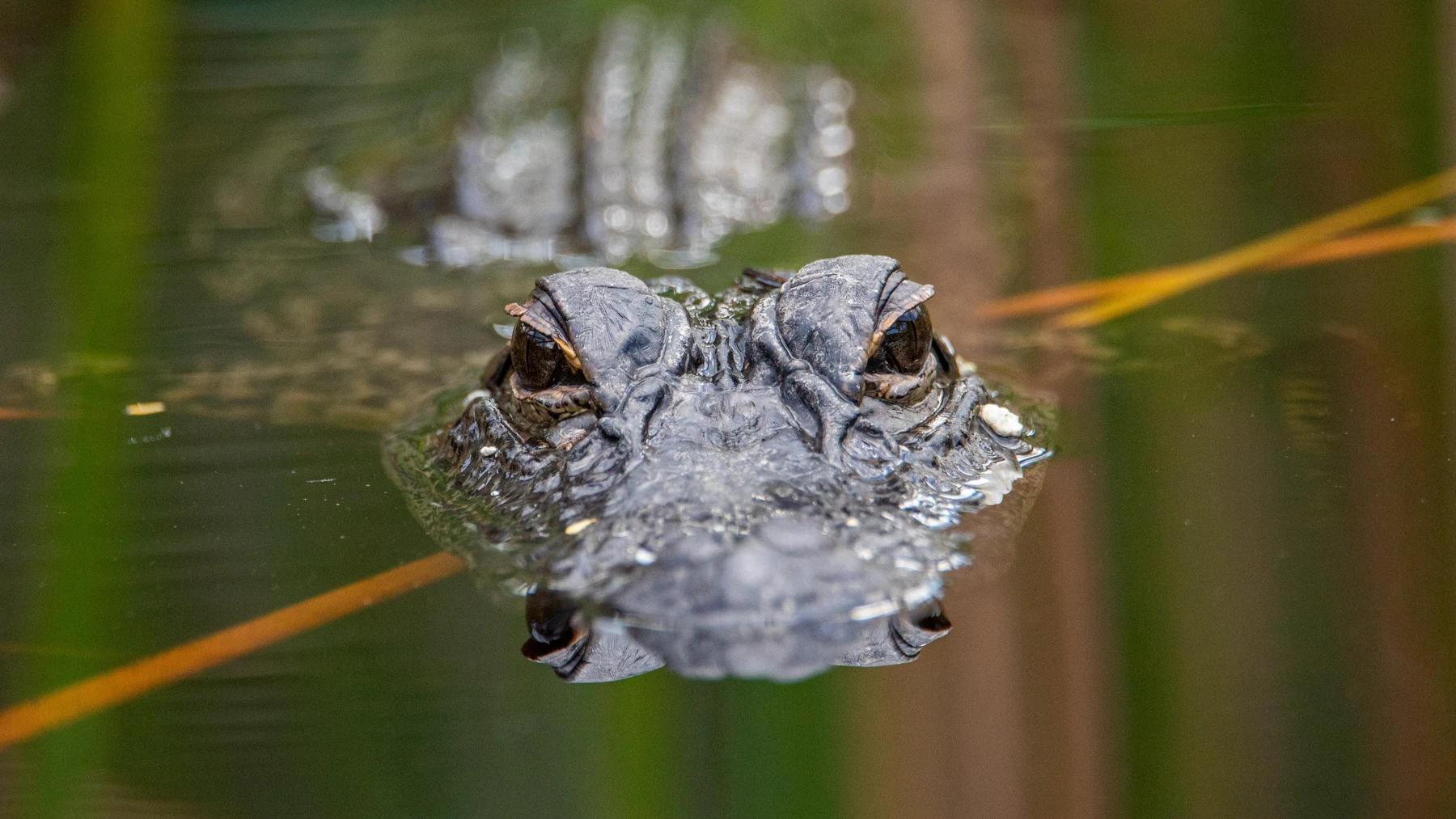
At another exhibit, the children found a photograph of an American alligator.
Augie immediately checked its feet.
“Those are not post-office shoes.”
Alligators were part of the wetland system, not decorations placed near a boardwalk for visitors. Their bodies, behavior, and habitat all deserved careful observation and plenty of space.
Allie read about alligator holes: depressions that alligators helped excavate and maintain by clearing vegetation and muck. When surrounding wetlands dried, these deeper places could retain water and become refuges for fish and other aquatic life.
Andy looked impressed.
“Construction department.”
“But not a free swimming pool,” Ana said.
Animals gathering at such a refuge could also become prey. And severe drought could dry holes that usually held water. The story was more complicated than a helpful alligator opening a community bath.
Augie drew a pool with a very large DO NOT ENTER sign.
Their parents reminded them that feeding wildlife was never part of their investigation. They would follow park distance guidance, leave animals an escape route, and move away if wildlife approached. With young children, staying well back from water’s edge mattered as much as keeping away from the animal itself.
They could learn from binoculars, exhibits, and photographs without trying to stand beside an alligator for a picture.
Ana added a note: AN ANIMAL CAN CHANGE ITS HABITAT.
They remembered beavers in Grand Teton’s chapter. Different animals, different work, but another example of a living thing shaping conditions for its neighbors.
Andy stamped his imaginary form.
“Engineer inspected from a respectful distance. Teeth not inspected personally.”
6. The birds read the water level
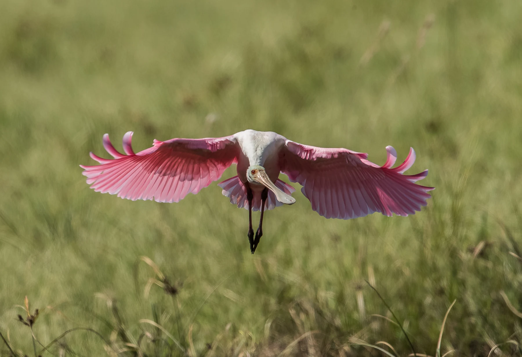
A long-legged bird stood quietly beyond their viewing place. The family watched without moving closer, taking turns with binoculars.
Andy whispered, “It has forgotten to sit down.”
“Or it’s looking for food,” Ana replied.
Their bird guide showed several ways of making a living around shallow water. Long legs could help a wading bird move through water, while different bills suited different ways of finding and catching prey. The children compared shapes before trying to name the distant bird.
Augie studied a spoonbill photograph.
“Breakfast equipment.”
A roseate spoonbill swept its broad bill through shallow water and detected small prey by touch. Other birds could watch carefully and strike with a pointed bill. Similar surroundings did not mean every species used the same technique.
Allie drew several bills beside her food-web arrows.
“The water depth changes what they can reach.”
As water receded, prey could become concentrated in remaining shallow pools. That could help some wading birds feed. But drying too far or at the wrong time could create problems. More water everywhere was not automatically better, and less water everywhere was not automatically better either.
Andy examined their calendar drawing.
“The restaurant needs the right floor height.”
“Depth,” Ana said. “And timing.”
The family stayed quiet, kept the route clear, and did not offer food to improve the performance. When the bird moved out of sight, they let it go.
Augie closed the guide with great care.
“Breakfast meeting finished.”
Their investigation now had another important clue: the water’s schedule could matter as much as the amount of water on a map.
7. The trees put their legs in the sea
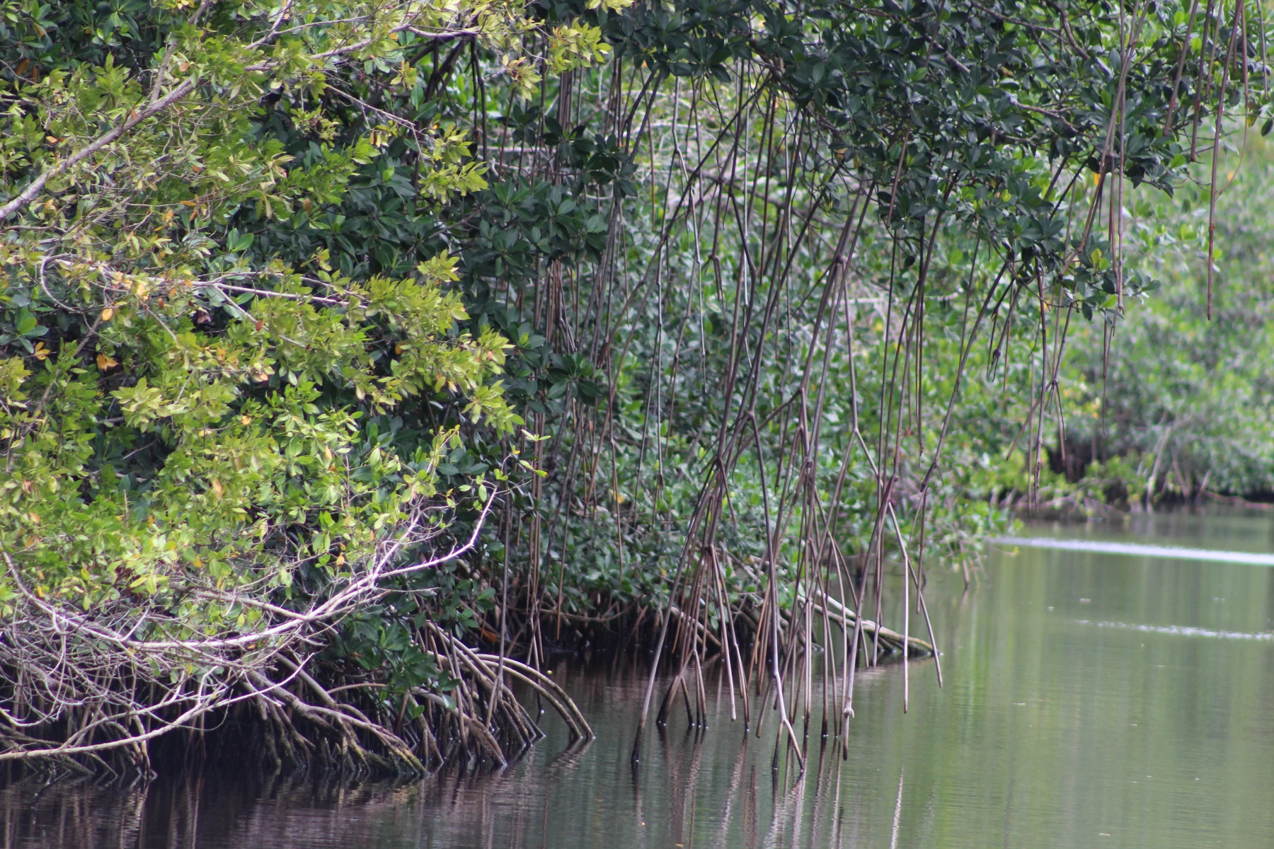
At a coastal interpretation stop, the children compared photographs of open marsh and mangrove forest.
“Those trees are standing on elbows,” Andy said.
Red mangroves had branching, stilt-like prop roots. Together with other mangrove species, they grew in coastal settings where fresh water and salt water could mix. Mangroves were salt-tolerant trees, but the name did not describe one single species or mean that every tree liked unlimited salt.
Ana followed a root in a photograph.
“The roots make lots of little spaces.”
Fish and other animals could use mangrove habitat for shelter and feeding; young marine animals found valuable nursery habitat there. Leaves and other organic material also became part of coastal food webs.
Augie remembered Olympic’s nurse logs.
“Another nursery. Still no cribs.”
Allie drew the marsh, a mangrove fringe, and coastal water as connected areas. The park was not entirely fresh water. It included marine and estuarine habitats too.
“An estuary is where fresh water from the land meets and mixes with seawater,” she read.
Andy added a sign: PLEASE MIX CAREFULLY.
The actual mixing depended on fresh-water inflow, tides, weather, and other conditions. Their pencil drawing could show the idea without pretending that the boundary stayed in exactly the same place.
They did not need a boat trip through every channel to understand the connection. Any boating would require its own planning and appropriate equipment. A photograph and an established viewing place were enough for this part of the case.
Augie drew the long-legged mailbox again.
“Now it needs waterproof envelopes.”
The river hidden in the grass was connected all the way to a salty neighborhood.
8. Who changed the delivery route?
The family’s next map looked different. It showed canals, roads, levees, and other human changes to the wider Everglades system.
Andy put down his imaginary inspector’s stamp.
“Someone really did move the water.”
People had drained wetlands and redirected flows for farming, settlement, flood control, and other needs. Those changes affected how much water reached different places, when it arrived, and its quality.
Allie compared this map with their first broad arrow.
“Restoration is more complicated than opening one giant tap.”
Scientists, engineers, Tribal nations, public agencies, and other partners worked on protecting and restoring the ecosystem while considering people’s water needs. Improving flow, water quality, and timing required connected decisions, not simply making every place deeper.
Ana thought of the bird feeding in shallow water and the fish needing a dry-season refuge.
“Different neighbors need different conditions.”
The children also learned that Seminole and Miccosukee peoples maintained deep, living relationships with the Everglades. Earlier Indigenous communities, including the Calusa, belonged to the region’s long human history. Park boundaries did not mark the beginning of people knowing or caring for this landscape.
Allie wrote a question to explore through Tribal voices: what does caring for the Everglades mean to the people whose home it is?
Augie pointed at the map.
“Not an empty field.”
“Not even close,” Ana said.
Their investigation had started with missing riverbanks. It now included homes, histories, livelihoods, and choices far beyond the boardwalk. Andy drew several hands around the water arrow, each holding a different part of the same complicated map.
9. The river keeps its own shape
Back at their table, Allie arranged the case pages. A broad flow arrow. A water calendar. A miniature lunch factory. An alligator hole. Bird bills. Mangrove roots.
“Did the river lose its banks?” she asked.
Ana shook her head.
“We expected a narrow river. Here, water can move broadly and slowly through gently sloping wetlands, with deeper sloughs helping carry it.”
“And the height of the water changes the neighborhood,” Andy added. “Where things grow. Where fish can stay. Where birds can eat.”
Augie tapped the picture of periphyton.
“And who makes mud lunch.”
Allie added that the Everglades was a mosaic, not one endless identical marsh. Different habitats and communities were connected by water. The park protected part of a larger system whose health depended on what happened outside its boundary too.
Andy wrote a new postal notice: DELIVERY TIME, AMOUNT, AND QUALITY ALL MATTER.
Augie drew a fish opening an envelope.
“What does the letter say?” Ana asked.
“Dear Fish. Your water is here.”
Their parents smiled. It was a funny picture of a serious connection.
Allie turned to their next chapter: Arches National Park. A great opening curved through red rock in the photograph.
Andy leaned forward.
“Someone forgot the glass in the window.”
“Or the wall has a story,” Ana said.
Augie placed his imaginary stamp in the notebook.
“Next delivery: one rock window.”
The Everglades river had not needed to become their usual idea of a river. The explorers had needed to change the way they looked. Their next mystery was already asking them to do it again.
Explorer’s notebook
Nine discoveries to take with you
- Everglades National Park is in South Florida and protects wetlands, forests, coastal, and marine habitats.
- Water can move broadly across gently sloping land as sheet flow, with deeper sloughs helping channel it.
- Sawgrass is a sedge with sharp leaf edges, rather than a true grass.
- The timing, depth, and duration of flooding help shape different habitats.
- Periphyton communities support small animals and wider food webs.
- Alligator holes can provide dry-season refuges, though drought and predation still matter.
- Wading birds use different feeding methods and depend on suitable water conditions.
- Mangrove and estuarine habitats connect fresh water with coastal seawater.
- Human changes, restoration, and living Tribal relationships are part of the Everglades story.
Five ways to explore thoughtfully
Plan with an adult using current park guidance, weather, wildlife rules, accessibility information, and your family’s abilities. These are options across a visit, not a one-day checklist.
- Observe water and plants from a suitable boardwalk or overlook. Stay on the route and away from shorelines and wildlife.
- Compare wet-season and dry-season photographs. Ask how the same place may function differently through time.
- Investigate periphyton through exhibits or close photographs without disturbing the marsh.
- Watch birds with binoculars from a respectful distance. Compare bills, legs, and feeding behavior; sightings vary.
- Explore a map connecting marsh, slough, mangrove, and coast. Learn about restoration and seek interpretation shared by Seminole and Miccosukee voices.
Three questions for the crew
- How can water be moving even when a landscape looks almost flat?
- Why might both flooding and drying at suitable times be important?
- Can you connect periphyton, small aquatic animals, and a larger predator in a food web?
Words worth keeping
- Sheet flow: water moving broadly across a shallowly flooded landscape.
- Slough: a low-lying wet area that helps channel slow-moving water.
- Hydroperiod: the length of time an area remains flooded.
- Periphyton: a community of tiny organisms and associated material growing on submerged surfaces or forming mats.
- Estuary: a place where fresh water from land meets and mixes with seawater.
- Restoration: work to help recover ecological conditions and processes that have been damaged or changed.