1. One mountain range, several outfits
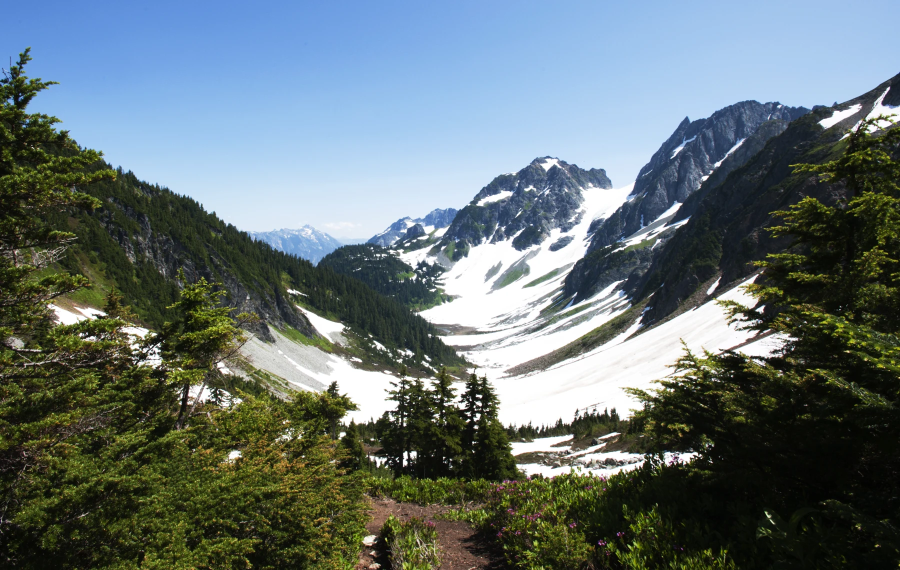
Augie arrived with a drawing of a mountain wearing a raincoat on one side and snow boots on top.
“The mountain couldn’t decide what to wear.”
Andy studied the picture. “It may need a different suitcase for each slope.”
The family’s next adventure was in Washington’s North Cascades. After the huge mountain landscapes of Wrangell–St. Elias, another serrated skyline rose into their questions. This time, they were investigating how wet forests, glacier ice and drier country could belong to the same mountain region.
Allie opened their notebook and wrote the title: The Rainforest Beside the Ice.
Ana drew a line beneath it. “Beside doesn’t have to mean a tree is touching a glacier. Let’s look at different elevations and different sides of the mountains.”
Their grown-up had chosen suitable short explorations and park interpretation. Photographs would bring distant glaciers and habitats into the investigation. The children did not need to climb onto ice or complete a high-country crossing to follow a good question.
In the wetter western forests, trees and an understory of green plants created a very different view from bare high peaks. The title invited them to investigate that contrast, not to call every forest in the North Cascades a rainforest.
“The forest is wearing a fuzzy sweater,” Augie said.
Andy added moss to his mountain drawing. Then he paused.
“If we blame everything on the height, how do we explain a wetter side and a drier side?”
Allie wrote their main question: How do moving air, mountain height and stored snow connect these neighboring worlds?
Ana added an arrow arriving from the Pacific Ocean.
“We may need to follow something we can’t see.”
Augie peered into the air.
“Very sneaky weather.”
2. The mountain lifts the air
The children began with moist air arriving from the Pacific. When winds carried it toward the mountains, the terrain could force that air upward.
Andy moved a paper arrow up the slope of their drawing.
“A mountain elevator for air.”
As air rose into lower pressure, it expanded and cooled. With enough cooling, water vapor could condense into tiny cloud droplets. Clouds could also contain ice particles. Further cloud processes could produce precipitation.
Allie drew three labels along the arrow: rise, expand, cool.
“Not the mountain grabbing a cloud and wringing it out,” she said.
Augie held up a sponge from their activity supplies.
“But this is an excellent pretend cloud.”
“A useful model for where water lands,” Ana replied. “Not for explaining why air cools.”
That distinction mattered. A squeezed sponge released water because a hand compressed it. Air lifted over mountains cooled as it expanded. The classroom object could begin a conversation without becoming the whole explanation.
Andy drew a crossed-out hand above the mountain.
“No giant weather fingers.”
Cloud droplets and falling rain were also different things. Water vapor was an invisible gas. A visible cloud contained tiny liquid droplets or ice particles, and precipitation needed particles large enough to fall.
Augie gave the vapor arrow a dotted outline so he would remember it was not a little visible river floating overhead.
Their diagram was getting more precise. It showed moisture arriving, air rising and cooling, clouds forming and some water returning to the land as rain or snow.
Ana pointed to the top of the mountain.
“Whether it falls as rain or snow depends on conditions. The same mountain storm can give different places different experiences.”
Allie put a jacket beside the forest and a snowflake beside the heights. The mountain’s complicated wardrobe was beginning to make sense.
3. The forest keeps more than tall trees
On a suitable short forest exploration, the family looked for layers: high branches, smaller trees, shrubs, ferns and plants close to the ground. Park photographs helped them compare features beyond their route.
Moist conditions and relatively mild winters supported large evergreen forests in western lowland valleys. Western hemlock, western redcedar and Douglas-fir were among the trees described in park information.
Augie stretched both arms toward the canopy.
“The upstairs neighbors are very upstairs.”
Allie made a forest cross-section in the notebook. Ana added a fallen log and a standing dead tree, called a snag.
“Old growth isn’t just a contest for the biggest trunk,” she said.
Forests could contain trees of different ages and heights, openings where light reached lower plants, and dead wood that provided habitat. As organisms broke down fallen material, nutrients and organic matter became part of the forest floor.
Andy remembered the decomposers in their Katmai food web.
“The cleanup team also builds the next chapter.”
A fallen tree could create both an opening overhead and a new surface below. A mossy log was not simply a broken object waiting to be removed. It could hold moisture and shelter living things.
Augie drew a front door on one end of the log.
“Tiny apartment building.”
Their grown-up kept the exploration on the appropriate route. The children could observe the log’s role without peeling bark, pulling up moss or testing whether every old trunk could support a climber.
Ana added light, water, shelter and nutrients around the forest drawing. Rain helped explain the green landscape, but each plant also depended on other conditions and interactions.
Allie looked from the forest page to the air arrows.
“The mountain changes where moisture arrives. The forest does a lot with what arrives.”
Their explanation now had living layers as well as cloud layers.
4. Winter water stays in the mountains
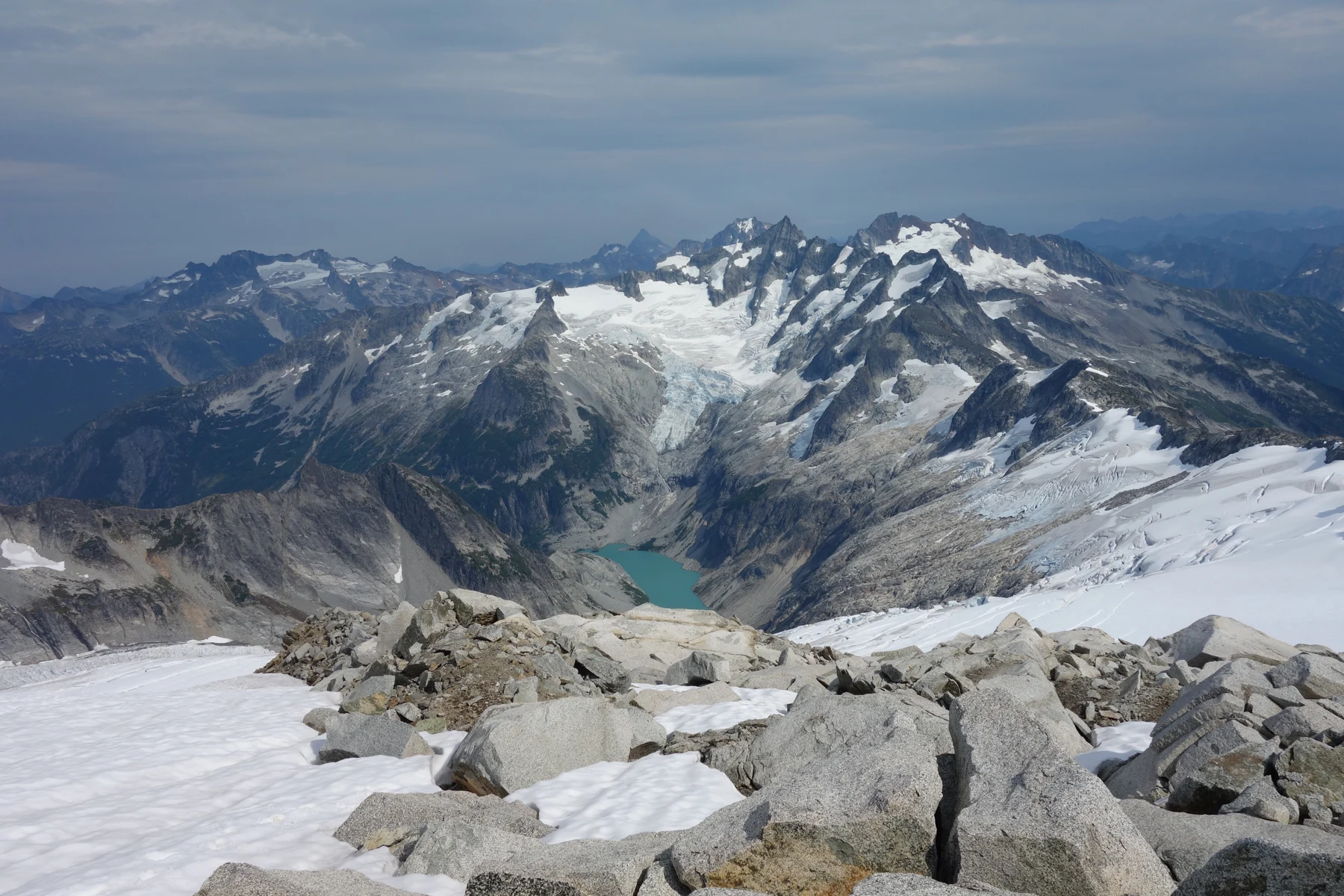
A glacier photograph brought the children from green forest to white high country. They studied it alongside park information rather than treating it as a route to follow.
Snow could accumulate where enough survived the warmer season. Buried layers changed and compacted into denser ice. A glacier could then flow under its own weight, deforming internally and sometimes moving at its base.
“Solid ice with travel plans,” Andy said.
Allie drew a seasonal comparison: snow arriving, some melting, some remaining. Then she added another year, and another.
“A cold winter alone doesn’t make every snow patch a glacier.”
Ana connected this page with their Kenai Fjords and Wrangell–St. Elias investigations. Ice could erode rock, carry debris and help carve valleys and hollows. Where glaciers worked on neighboring slopes, sharp ridges could remain between the carved spaces.
Augie looked at the pointed skyline.
“The mountain has teeth.”
“Rock teeth,” Andy said. “No need to feed them.”
The North Cascades held many glaciers, but the children did not need a changing glacier count to understand their importance. Snow and ice stored water that could later enter streams. Melt could contribute cold water during parts of the year when rain and seasonal snow supplied less.
That storage was not an endless supply. Glaciers gained and lost mass, and long-term losses could change their future contribution to streams. More melting for a time did not mean more ice would remain forever.
Scientists measured accumulation and melt and compared observations over years. Allie wrote two questions: how much is added, and how much is lost?
Augie put a small label beside his glacier drawing: WATER SAVED FOR LATER.
Ana added a second line: the amount can change.
Their mountain reservoir needed both labels.
5. The lake has color, but no paintbrush
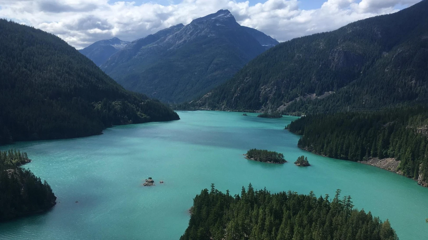
One park photograph showed Diablo Lake between forested mountain slopes. Its blue-green water looked almost as if somebody had stirred color into it.
Augie examined the page.
“The glacier owns a paint set.”
“No paint required,” Allie replied.
Glacial erosion produced very fine rock particles, sometimes called glacial flour. Streams could carry those particles into the lake. Suspended in the water, they interacted with light and contributed to its distinctive turquoise appearance.
Ana drew tiny particles between a glacier and a lake. They were not dissolved blue dye. The amount of suspended material, sunlight and other viewing conditions could change the color people saw.
Andy wrote beneath the photograph: a real view, not a color promise for every day.
The family also checked the map. Diablo Lake lay in Ross Lake National Recreation Area, part of the North Cascades National Park Service Complex. The complex included the national park and neighboring recreation areas, including Lake Chelan National Recreation Area.
“We should name the place accurately,” Ana said. “Connected landscapes can still have different map labels.”
Diablo Lake was also a reservoir, with a dam part of its story. Its water connected natural processes and human infrastructure. A beautiful color did not erase the need to ask how a place was shaped and managed.
Augie drew two labels beside the water: rock flour and reservoir.
“This lake has more homework than my paint set.”
The children studied the photograph from their notebook, without claiming a particular lake visit or weather condition. Allie traced their arrows back uphill: water, sediment, glacier, snow and moving air.
A lake’s color had led them through several pages of explanation. The glacier’s work could be visible far below the ice, if they knew which clues to follow.
6. The other side is in a rain shadow
Andy turned their mountain drawing around.
“If the west gets all that moisture, what happens beyond the crest?”
Ana moved the air arrow down the eastern slope. Some moisture had already fallen on the windward side. As air descended, it compressed and warmed. Its relative humidity could fall, making cloud formation less favorable.
The mountains helped create a rain shadow: a region receiving less precipitation on the sheltered side.
Augie drew a dark shape behind a paper mountain.
“Like standing behind a lamp?”
“The word sounds similar,” Allie said. “But it’s not a shadow made by blocking light.”
Nor was the east side completely rainless. Storms, seasons, elevation and local terrain still mattered. The pattern explained a broad contrast, not tomorrow’s forecast for every valley.
Andy divided a page into wetter west, snowy heights and drier east. Then Ana rubbed out the straight borders between them.
“Useful categories,” she said. “The real transitions overlap.”
Park descriptions showed forests changing across the region. Drier eastern lower slopes could support trees such as ponderosa pine and Douglas-fir, with other communities higher up. Wetter western forest plants did not occur in identical arrangements everywhere.
Allie added a north-facing slope and a sunny slope to remind them that exposure also affected conditions.
Their wet-sponge model could show water falling mostly on one side, but it could not demonstrate descending air warming. The family kept that limitation beside the model instead of hiding it.
Augie gave his mountain a wet sweater on the west and a dry jacket on the east.
“Better packing list.”
Their grown-up checked the real conditions before any outing. A regional climate pattern helped explain the landscape; actual weather and access still decided what the family could do that day.
7. The mountain squeak has winter supplies
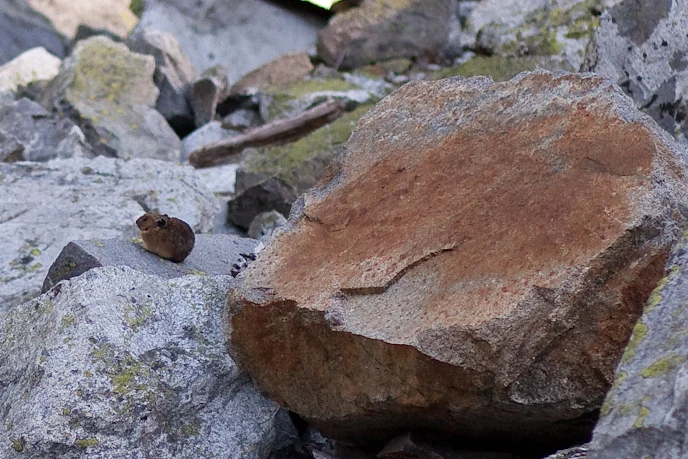
The children listened to a pika recording through park material and examined a photograph of the small animal. Its rounded body and short ears looked nothing like the mountain goat Andy had first imagined making the sound.
Augie grinned.
“The mountain squeaked.”
“A pika called,” Ana said. “The rocks didn’t.”
American pikas lived among broken rock and nearby vegetation in suitable habitats. They ate plants and collected material in caches often called haypiles. Since they did not hibernate, stored food helped them through the colder months.
Andy drew a pantry under a rock.
“Very small grocery storage.”
Allie added gaps between the rocks. Those spaces could offer shelter and different temperatures from the exposed surface. A talus slope was a whole habitat, not merely a pile of stones around an animal.
Snow could matter in more than one way. Deep enough cover could insulate spaces beneath it, while changes in snow timing and warm-season temperatures could affect conditions for cold-adapted animals. Pika responses varied with local habitat; one hot day or one silent rock pile could not establish the history of an entire population.
Scientists looked for evidence such as sightings, calls and haypiles during carefully designed surveys. The family’s activity stayed with recordings, photographs and interpretation. They would not climb unstable rocks, move a haypile or offer food to obtain a closer view.
Augie drew a sign beside his pantry: PIKA FOOD ONLY.
Their earlier climate diagram had contained only air, water and mountains. Now an animal’s food and shelter belonged on it too.
Ana placed a pika symbol beside the snowpack question.
“What happens to snow can also matter to something that doesn’t live inside a glacier.”
Allie circled that connection. It was one of their most useful discoveries.
8. The mountain is a connection, not a blank wall
Their map now showed different conditions on either side of the crest. It would have been easy to draw the mountains as a wall dividing two unrelated worlds.
Park history offered another view.
The lands of the North Cascades complex were traditional homelands of Coast and Interior Salish peoples. Distinct Tribes maintained deep relationships with the region, including the Upper Skagit, Nooksack and others. The family would learn about those connections through community accounts and park interpretation, rather than treating all peoples as one group.
Allie wrote a question beside the crest: who traveled through, and what did they know?
Mountain passes had served as travel and trade routes. Familiarity with seasons, terrain and resources mattered. Places with different climates could be linked through knowledge and movement rather than separated by an empty strip on a map.
Ana drew a route across their paper range, keeping it clearly labeled as a historical idea, not directions for a family hike.
“Our air arrows weren’t the first journeys through this landscape.”
Andy added rivers flowing toward lower valleys. Snowmelt, glacier melt, rain and groundwater could all contribute to stream systems. Forest shade and other habitat conditions also influenced the water that fish and other organisms used.
After Katmai, the children knew salmon connections did not end at one dramatic waterfall. Here, mountain water connected high country with lower rivers and communities.
Augie drew a tiny envelope floating downhill.
“Water messages from the mountains.”
Allie added that a stream carried more than a message: water, sediment and effects that could matter downstream. The region’s histories and living relationships deserved attention alongside its weather pattern.
They packed their materials and every crumb away. A useful investigation left its questions in the notebook, while leaving habitats and cultural places intact.
9. The mountain’s wardrobe makes sense
Allie placed Augie’s first drawing beside the finished diagram. The mountain still had a raincoat on one side and snow boots near the top.
“This time,” she said, “let’s explain every piece.”
Ana began with the invisible journey. “Moist air can be lifted by the range. As it rises, it expands and cools. Enough cooling helps form clouds, and cloud processes can produce rain or snow.”
Andy followed the water. “Moisture helps support wetter forests. Snow can accumulate high up, and glaciers store and release water while reshaping rock.”
Augie chose the east-side jacket. “Air going down can warm up. The other side gets less rain, but not zero rain.”
Allie added the connections below the drawing: stream habitats, suspended rock particles, pika shelter and people’s continuing relationships with the landscape.
Their title had sounded like two impossible neighbors. Now The Rainforest Beside the Ice described a regional contrast they could investigate, with wet forest and cold high places linked through air and water.
“The forest doesn’t need to move onto the glacier,” Ana said. “The connections already reach between them.”
Andy removed the giant hand squeezing the pretend cloud. They kept the sponge in the activity box, with its limitation written clearly on the model card.
“A good model helps,” he said. “A better explanation knows where the model stops.”
Augie gave the pika pantry a roof made from a drawn rock.
“One mountain range. Several outfits. Snacks stored by a professional.”
Allie wrote their next destination: the National Park of American Samoa, where rainforest would lead to a different island story involving volcanic land, reefs and Samoan culture.
They closed the notebook with a weather question still open. Tomorrow’s clouds would be their own event. The pattern the children had learned would help them ask why, without pretending to predict every drop.
Explorer’s notebook
Nine discoveries to keep
- Moist air arriving from the Pacific can be lifted as it meets the North Cascades.
- Rising air expands and cools; water vapor can condense into cloud droplets, and clouds can also contain ice particles.
- Wet western forests contain layers of living plants, dead wood and habitats, not only tall trees.
- Snow surviving and accumulating over time can become glacier ice that flows under its own weight.
- Snow and glaciers store water and can contribute to streams, while their future supply depends on gains and losses.
- Fine rock particles carried from glaciers can help give Diablo Lake its turquoise color.
- Descending air can warm, helping create a drier rain-shadow region east of the crest.
- Pikas gather plants for winter instead of hibernating, and their habitats include shelter among rocks and seasonal snow.
- Mountain routes, waters and living communities connect a region that remains a homeland for distinct Native peoples.
Five family adventures
- Draw the moving-air journey. Make a mountain cross-section with an ocean to the west. Add arrows for moist air rising, expanding and cooling, then descending and warming. Draw clouds only where your explanation supports them. Use different symbols for invisible vapor, cloud droplets and falling precipitation, and explain why a cloud is not simply visible water vapor.
- Use a sponge, then critique it. With a grown-up, hold a damp sponge over a paper mountain inside a washable tray and gently squeeze water onto one side. Record what the model shows about where water lands. Then write what it does not show: air expanding and cooling, cloud formation or descending air warming. Dry the work area afterward and do not treat squeezing as the cause of mountain rainfall.
- Make a forest-layer foldout. Draw canopy, smaller trees, shrubs, ground plants and a fallen log on separate folded panels. Add one role for water, light, shelter and decomposition. Use photographs or observation from an appropriate path; leave moss, bark, plants and dead wood where they belong.
- Keep a mountain water budget. Use paper tokens to represent snow and ice. In each pretend year, add an amount for accumulation and remove an amount for melt or other losses. Compare years with a gain, a balance and a loss. Explain that a glacier has complex movement and changing conditions that tokens cannot reproduce. No experiment on real snowfields or glacier margins is needed.
- Build a pika pantry on paper. Draw vegetation, a haypile, rock spaces and winter snow. Add labels explaining food storage, shelter and insulation. Compare your drawing with park information and mark one question about warmer summers or changing snow. Keep real animals undisturbed; do not rearrange stones, haypiles or plants to improve a photograph.
Four questions for the road
- Why does air cool when it rises over a mountain, and why is a squeezed sponge only a limited model?
- How can wet forests, snowy heights and drier eastern valleys be part of the same region?
- Why is a glacier’s contribution to streams different from an unlimited supply of water?
- What relationships are missing from a mountain map that shows only elevation and weather?
Eight words for your explorer kit
- Water vapor: Water in its invisible gaseous state.
- Condensation: Change of water vapor into liquid droplets.
- Precipitation: Water falling from clouds as rain, snow or other forms.
- Windward: Facing toward an incoming wind, such as the side where moist air rises over a range.
- Leeward: On the side sheltered from the incoming wind.
- Rain shadow: A relatively dry region on the sheltered side of a mountain barrier.
- Glacial flour: Very fine rock particles produced by glacial erosion and often carried by meltwater.
- Talus: An accumulation of broken rock pieces on or below a slope.