1. An island with a rainforest hat
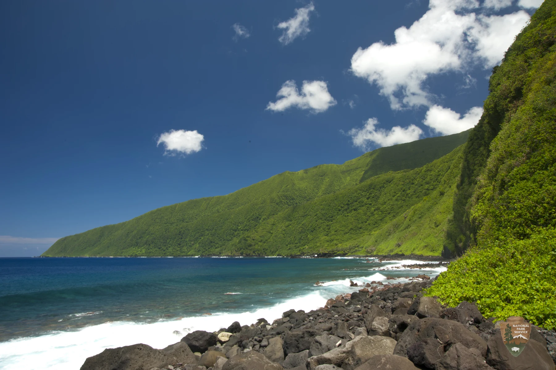
Augie had drawn another mountain outfit.
After the North Cascades adventure, his notebook contained raincoats, snow boots and one extremely soggy cloud. This new mountain wore green leaves from its shoulders to its head. Around the bottom, he had drawn blue water.
“Rainforest hat,” he announced. “Ocean shoes.”
Allie looked from the drawing to a park photograph. Steep green ridges rose above the South Pacific. The National Park of American Samoa protected places where tropical forests and coral reefs belonged to the same island story.
Ana found Tutuila, Ta‘ū and Ofu on the park map. The park had areas on all three islands. A line drawn across blue paper could make them look close, but the water between them was real ocean. Their family would use park interpretation and photographs to explore places beyond their suitable short outings on Tutuila.
“One chapter can visit more ideas than one pair of feet,” Andy said.
Their grown-up helped them distinguish American Samoa, a United States territory, from the neighboring independent country of Samoa. They were part of a wider Samoan island region, but a map needed accurate labels.
Allie wrote the chapter question: How do a volcanic island, a rainforest, a reef and a living culture belong to one connected place?
Augie wanted to begin with the hat. Ana wanted to begin underneath it.
“Before the trees, there had to be land.”
Andy turned a page sideways and drew an ocean line. He left most of the page below it.
“For the part the photograph doesn’t show.”
That blank space was their first discovery. An island was not simply a little hill resting on top of the water. The visible land could be the upper part of a much larger mountain built from the ocean floor.
Augie added an enormous dotted mountain under his island.
“The shoes are very deep.”
2. The mountain beneath the water
The children used park geology information to follow the island’s beginnings. Volcanic material had accumulated through repeated eruptions, building mountains that rose from deep beneath the Pacific. The island landscapes belonged to a chain of volcanic features.
Andy stacked strips of dark paper beneath the ocean line.
“One strip is one layer in our model. Not one exact eruption.”
Some volcanic material began as lava: molten rock that had reached the surface. When it cooled, it became solid rock. Other eruptions produced broken volcanic material. Over long spans of time, such materials built and reshaped the islands.
Allie labeled the dark foundation volcanic rock. She did not label it coral.
“That matters later,” Ana said. “Different builders can contribute to the same island landscape.”
The family also learned the term shield volcano. It described a broad volcanic form built largely by flowing lava. The steep ridges and valleys they saw in photographs were not a promise that every volcano looked like a simple, perfect cone. Erosion, collapse and other changes could alter a volcanic mountain’s shape.
Augie erased the pointy party hat he had given his underwater mountain.
“It has had a complicated haircut.”
Rain, streams, waves and gravity continued shaping rock after it formed. A forest-covered ridge could therefore hold both a building story and a wearing-away story. The children could see a landscape at one moment while learning about processes that had worked for far longer than their visit.
Their grown-up reminded them that a chapter about volcanic origins was not a report on today’s volcanic conditions. Scientists monitored the region; current information belonged with the appropriate official guidance.
Allie added a question mark beside a fresh-looking line in a photograph.
“We can ask what shaped it. We can’t decide its whole history just from its color.”
Augie wrote his own summary beneath the diagram: The island started before the trees had anywhere to stand.
3. A forest built for tropical rain
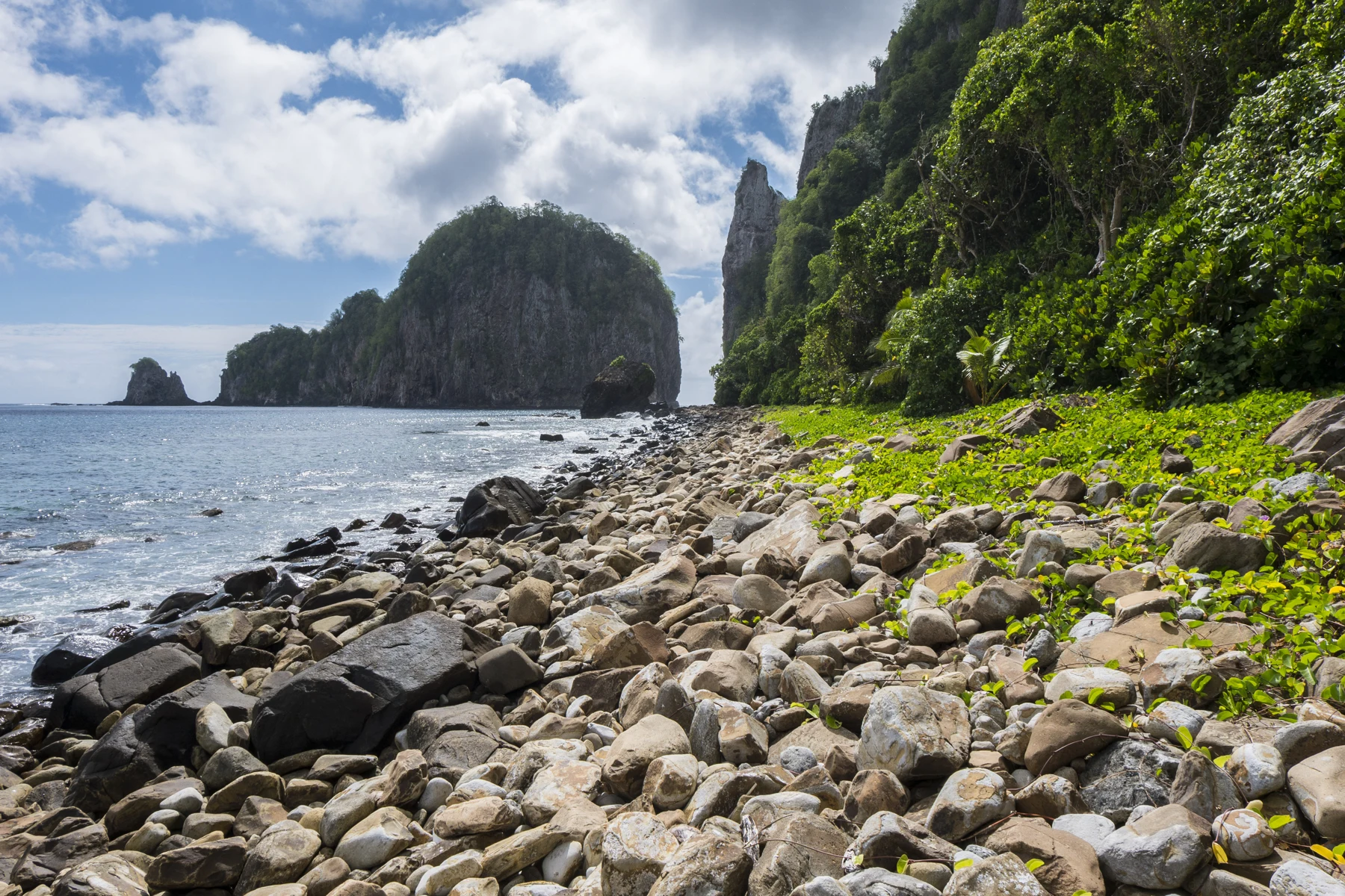
Now they could investigate the hat.
The children compared rainforest photographs from American Samoa with the wet western forests they had just studied in the North Cascades. Both could be green and rainy, but that did not make them the same forest.
“This one lives in a warm tropical climate,” Ana said. “The same word can introduce different communities.”
Park information described tropical rainforest covering much of the volcanic islands. Warmth and abundant rainfall supported many kinds of plants. Trees, smaller plants, vines and ferns formed layers rather than one flat green blanket.
Allie drew a canopy above an understory. Andy added the forest floor and arrows for water moving through the picture.
Rain could strike leaves, drip downward, soak into soil or run over the ground. The proportions depended on the storm, the slope, the soil and the condition of the vegetation. A leaf did not catch every drop, and a root did not stop every grain of soil.
“Not a waterproof umbrella,” Andy said.
“More like a busy neighborhood for water,” Allie replied.
Roots helped hold soil. Fallen plant material covered parts of the ground. Living plants took up water, and some water returned to the air. The forest was doing more than decorating the mountain.
Augie put a green paper roof over his drawing, then added trunks, leaves on the ground and roots underneath.
“The hat has plumbing.”
They listened during a suitable pause outdoors, with their grown-up choosing where to stop. The children could notice the sounds around them without identifying every caller or turning every movement into a rare animal sighting.
Ana made two notebook columns: what we observed and what we learned from park information. A photograph of a distant forest belonged in the second column. The warm air around their own stop belonged in the first.
“All the evidence counts,” she said. “We just need to say where it came from.”
4. Flying gardeners without watering cans
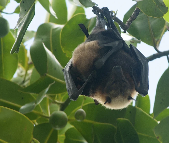
A park photograph introduced an animal Augie had not included in his forest hat: a fruit bat.
“Flying gardener!” he said.
The name was playful, but the connection was real. American Samoa’s fruit bats fed on fruit and flowers. As they moved between feeding places, they could carry pollen and disperse seeds. Those movements helped connect plants across the forest.
Allie drew a bat beside a flowering tree. She made the pollen arrow a different color from the seed arrow.
“Two jobs, two explanations.”
Pollen transfer could help a plant reproduce. Seed dispersal moved seeds away from the parent plant. A seed carried to a new place was not guaranteed to become a tree: it still needed suitable conditions, and many seeds never survived to grow.
Andy added a small question mark beside each scattered seed.
“No automatic forest button.”
Park materials introduced two kinds of large fruit bats, including the Samoan fruit bat, and distinguished them from a smaller insect-eating bat. Not every bat had the same food or the same habits. Calling all bats mosquito hunters would miss an important part of this forest’s story.
Augie studied the animal’s folded wings in the photograph.
“It brought its own cape.”
The children did not need to approach a roost or handle an animal to understand its role. Their grown-up helped them use photographs and interpretation, leaving resting and feeding animals undisturbed.
Ana connected three notebook cards: flower, fruit bat and future plant. Then she connected fruit, fruit bat and scattered seed.
“If the forest loses an important seed mover, the effect can reach beyond that animal,” she said.
Allie wrote relationships across the top of the page. A forest was not merely a list of separate species. It was also a place where feeding, shelter, reproduction and movement linked one living thing to another.
Augie added a tiny watering can to his bat, considered it, then crossed it out.
“Gardening by flying is already enough work.”
5. Where the mountain’s water travels
Andy traced a blue line from a ridge toward the coast.
“If rain falls up here, can something down there notice?”
The answer carried their investigation beyond the forest. Water moving downhill could transport soil and other materials toward streams and coastal waters. What happened on land could affect the sea.
Ana drew a boundary around the slopes draining toward one outlet. This was a watershed: an area where water drained toward a shared place.
“The map line isn’t a wall,” she said. “It helps us follow the route.”
Forest cover could reduce erosion and help retain soil. Removing vegetation or disturbing ground could change how water and sediment moved. But storms, steep slopes and other natural processes also moved material. The children should not imagine that every cloudy stream meant someone had done something wrong.
Allie added two labels: natural processes and human changes. They could overlap in one watershed.
Too much sediment reaching a reef could create problems. Suspended particles could reduce light. Material settling onto corals could cover living surfaces. Nutrients and other pollutants carried by runoff could also alter conditions.
“An underwater neighbor can receive an upstairs problem,” Andy said.
Their grown-up helped them make a small tray model later, using folded paper hills and a few drops of water. It showed a direction of travel, not a real prediction of how much soil any forest would retain.
Augie placed a paper reef at the tray’s low end.
“Now the hat has a mailing address.”
Ana drew another arrow along the coast. Waves and currents also moved and stirred sediment. A land-to-sea diagram was useful, but the sea was not an empty bowl waiting motionless at the bottom of the hill.
Their notebook now had water moving down slopes and water moving along the shore. The connections were becoming more interesting than a single straight arrow.
6. A reef made by living animals
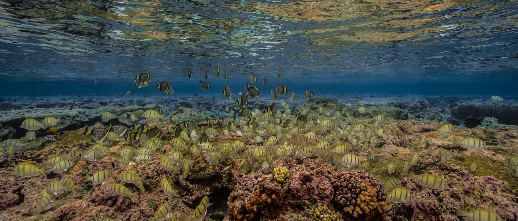
The children explored the reef through official photographs and interpretation. They did not need to enter unfamiliar water to discover that the blue edge of their map contained another community.
Augie pointed at branching and rounded shapes in a photograph.
“An underwater forest?”
“A useful comparison for shelter,” Ana said. “But coral isn’t a tree.”
Corals were animals. Many reef-building corals lived as colonies of small polyps, building hard calcium-carbonate skeletons. The living tissue and the hard framework were different parts of the story. A reef was not simply a collection of colorful rocks.
Allie drew a tiny polyp larger than life so they could see its tentacles. Beside it, she drew a colony and then a reef.
“Small builders, much bigger structure.”
Many shallow reef-building corals hosted microscopic algae in their tissues. In sunlight, the algae made food through photosynthesis and shared energy with their coral hosts. The relationship helped explain why light mattered to many shallow reefs.
Andy connected the sunlight arrow to the algae, rather than drawing coral roots into sand.
“Different partnership from a forest tree.”
Fish and many other organisms used reef spaces. Some fish grazed algae; others had different diets. No single fish could be assigned the job of cleaning an entire reef, but feeding relationships helped shape the community.
Augie drew a fish with a broom. Then he replaced the broom with an arrow marked grazing.
“The fish has enough to carry.”
Their grown-up explained that coral reefs faced several pressures, including warming seas and poor water quality. Protecting forested slopes could help with some land-based pressures, but it could not solve every threat by itself.
Ana returned to their volcanic diagram. She labeled its foundation rock and added a separate reef framework in suitable shallow coastal water.
“The volcano helped build the island. Coral animals help build reef habitat. We shouldn’t give all the credit to one builder.”
7. A homeland, not an empty island
The children’s map was crowded with trees, bats and water arrows. Allie stopped before adding another nature label.
“Where are the people?”
They had been present in the story all along. These were inhabited islands with villages, families, work, knowledge and responsibilities. Samoan people had navigated the ocean, farmed, fished and cared for places across many generations. Their communities continued living and changing in the present.
The family learned about fa‘asamoa, often described as the Samoan way. It included customs, relationships and responsibilities, with family, community and land deeply connected. A short chapter could introduce the term, but it could not stand in for learning from Samoan people themselves.
Ana crossed out a heading she had begun: “Things from long ago.” She replaced it with living connections.
“History matters. So does today.”
Park interpretation explained an important partnership. Park land was leased from local villages rather than simply being purchased as federal land. Village leaders and the National Park Service worked together in caring for park resources and cultural heritage.
Andy looked at the boundary on the map.
“So a park line doesn’t mean the place stopped being someone’s homeland.”
Their grown-up helped them think about being guests. They would seek current park and local guidance, respect village protocols, ask before photographing people or entering places, and understand that a beautiful view did not create permission to go anywhere.
Augie drew a small speech bubble: May I?
“That belongs in an explorer kit,” he said.
They did not invent a ceremony or pretend a conversation had happened. Instead, they wrote questions they could respectfully bring to appropriate interpretation: Who cares for this place? What guidance should visitors follow? Whose knowledge are we learning from?
Allie drew people into the map without turning them into another wildlife symbol. A living community was not an exhibit for the family to collect.
8. Small islands, important connections
Ana imagined the map losing one of its arrows.
“What if a plant lost a seed disperser? What if an introduced animal changed which seeds survived?”
On islands, some species lived in limited areas, and ocean distances could restrict where they could move. Habitat loss or introduced species could therefore have serious effects. But the children needed to ask about each particular organism rather than announcing that every island species had the same problem.
Andy placed a new card on their diagram: introduced. It meant people had brought a species to a place outside its native range, deliberately or accidentally. It did not mean every introduced species caused the same harm. An invasive species could spread and cause damage.
Augie drew a suitcase beside the card.
“Sometimes things travel without buying a ticket.”
Their grown-up connected that thought to visitor care: follow current biosecurity instructions and avoid carrying seeds, soil or living things between places. Clean equipment and careful choices could matter well beyond a single trail.
Allie returned to the bat cards. A fruit bat needed food and places to rest. Plants could depend on animals moving pollen or seeds. A reef needed suitable conditions underwater, while some of its pressures began on land.
“Protecting one picture frame may miss something outside it,” she said.
Ana enlarged the notebook’s imaginary frame until it included ridge, village and coast. The family could not manage the whole island from a notebook, but they could learn to ask wider questions.
They also left room for evidence they did not yet have. A photograph could show a forest canopy. It could not tell them the population trend of every bat beneath it. Scientists and communities used repeated observations, local knowledge and monitoring to understand change.
Augie wrote look again beside their question marks.
“A good explorer doesn’t use up all the questions on the first page.”
9. Rainforest hat, coral shoes
At the end of their investigation, the children spread their pages in a row.
First came the mostly underwater mountain, built through volcanic processes. Then came the tropical forest with roots, leaves, pollen and seeds. A bat connected feeding places. Water carried their attention downhill. Coral animals helped create habitat in the sea.
The page about Samoan communities did not go at the very end like an extra decoration. Allie placed it beside the whole row.
“People belong throughout this story.”
Andy followed the arrows with one finger.
“Volcanic rock gives land a foundation. Rain and warmth help shape the forest. Animals connect plants. The condition of a watershed can matter to a reef.”
“And the reef has its own relationships,” Ana added. “It isn’t just the forest’s downstairs room.”
Their grown-up asked what the children would change in their first drawing.
Augie kept the rainforest hat. He replaced the ocean shoes with coral shoes, then added a note saying the shoes were a joke, not a diagram of where every reef grew.
Allie added the missing mountain below the sea. Andy added water routes and sunlight. Ana added people, partnerships and questions about respectful visiting.
Their main question had not ended in one enormous answer. It had opened into several connections, each needing its own explanation.
The children packed their notebook without collecting rock, coral, seeds or wildlife. Photographs, drawings and carefully labeled observations were enough to carry home.
On the next page waited Isle Royale, where wolves, moose and forests would invite a different investigation of relationships.
Augie checked that his bat still had no watering can.
“Rainforest hat,” he said. “Coral shoes. Very busy neighbors.”
Ana closed the notebook gently.
“And a place where being curious includes learning how to be a guest.”
Explorer’s notebook
Nine discoveries to keep
- The National Park of American Samoa protects areas on Tutuila, Ta‘ū and Ofu in the South Pacific.
- Volcanic islands can be the exposed tops of much larger mountains rising from the ocean floor.
- Tropical rainforest and the wet forests of the North Cascades have different climates and plant communities.
- Fruit bats help connect plants through pollination and seed dispersal; a dispersed seed still needs suitable conditions to grow.
- A watershed connects slopes to shared drainage places, and water can carry sediment and other materials toward the coast.
- Many reef-building corals are colonial animals that make hard calcium-carbonate skeletons; many shallow-water corals also host algae.
- Caring for land can help reduce some pressures on reefs, while waves, currents and wider ocean conditions also matter.
- Fa‘asamoa is a living way of life, and the park’s leased lands reflect partnerships with local villages.
- Island conservation depends on relationships among habitats, species and people, supported by evidence and respectful care.
Five family adventures
- Build the hidden mountain. Draw an ocean line on paper, then use paper strips to make a broad mountain with most of its height underwater. Add a green land surface above the line and label volcanic rock. Draw coral habitat separately near the shore. Explain that the strips are a simple model, not an eruption count or a scale drawing.
- Follow two flying-gardener routes. Make cards for a flower, pollen, a fruit bat, fruit, a seed and a suitable growing place. Arrange one route for pollen transfer and another for seed dispersal. Add a question mark where a seed might fail to grow. Use drawings only; do not handle bats or collect wild fruit or seeds.
- Trace a tiny watershed. Set folded waterproof scrap paper in a washable tray, making ridges and a low outlet. With a grown-up, add a few drops of clean water and trace where they travel. Draw a reef beyond the outlet on separate paper. Discuss what the model shows about direction and what it cannot show about real soil, roots, storms or currents. Keep the water in the tray.
- Make a reef relationship map. Draw sunlight, algae living inside a coral, a coral colony, a grazing fish and open water. Join the cards with labeled arrows, explaining the particular relationship rather than just saying everything helps everything. Add a sediment card and discuss how too much material in the water could change light or cover living surfaces. No collecting or water entry is needed.
- Prepare a thoughtful guest page. Read an official park page about Samoan culture with a grown-up. Record who published it, one thing learned and one question still open. Make a short visitor checklist about permission, photographs and current local guidance. Compare this with how your own family welcomes guests, without pretending the two cultures are identical or recreating a ceremony.
Four questions for the road
- How can a steep island ridge be part of a volcano whose much larger foundation is hidden underwater?
- What is the difference between moving pollen and moving a seed, and how might a fruit bat help with each?
- How could a change on a forested slope affect a reef, and what other processes might also influence that reef?
- Why does learning that park land is leased from villages change the questions a respectful visitor should ask?
Eight words for your explorer kit
- Volcanic island: Land above the sea formed from volcanic material, often with a much larger mountain beneath the water.
- Tropical rainforest: A forest in a warm tropical region with abundant rainfall and many connected layers of life.
- Pollination: Transfer of pollen to the parts of a flower where it can contribute to reproduction.
- Seed dispersal: Movement of seeds away from the plant that produced them.
- Watershed: An area of land whose water drains toward a shared outlet or receiving place.
- Coral polyp: A small animal; many reef-building polyps live in colonies and produce hard skeletons.
- Fa‘asamoa: The Samoan way, including living customs, relationships and responsibilities rooted in Samoan community and culture.
- Stewardship: Care for places and resources through informed actions and responsibilities, often shared across communities and generations.