1. Every landscape on the menu
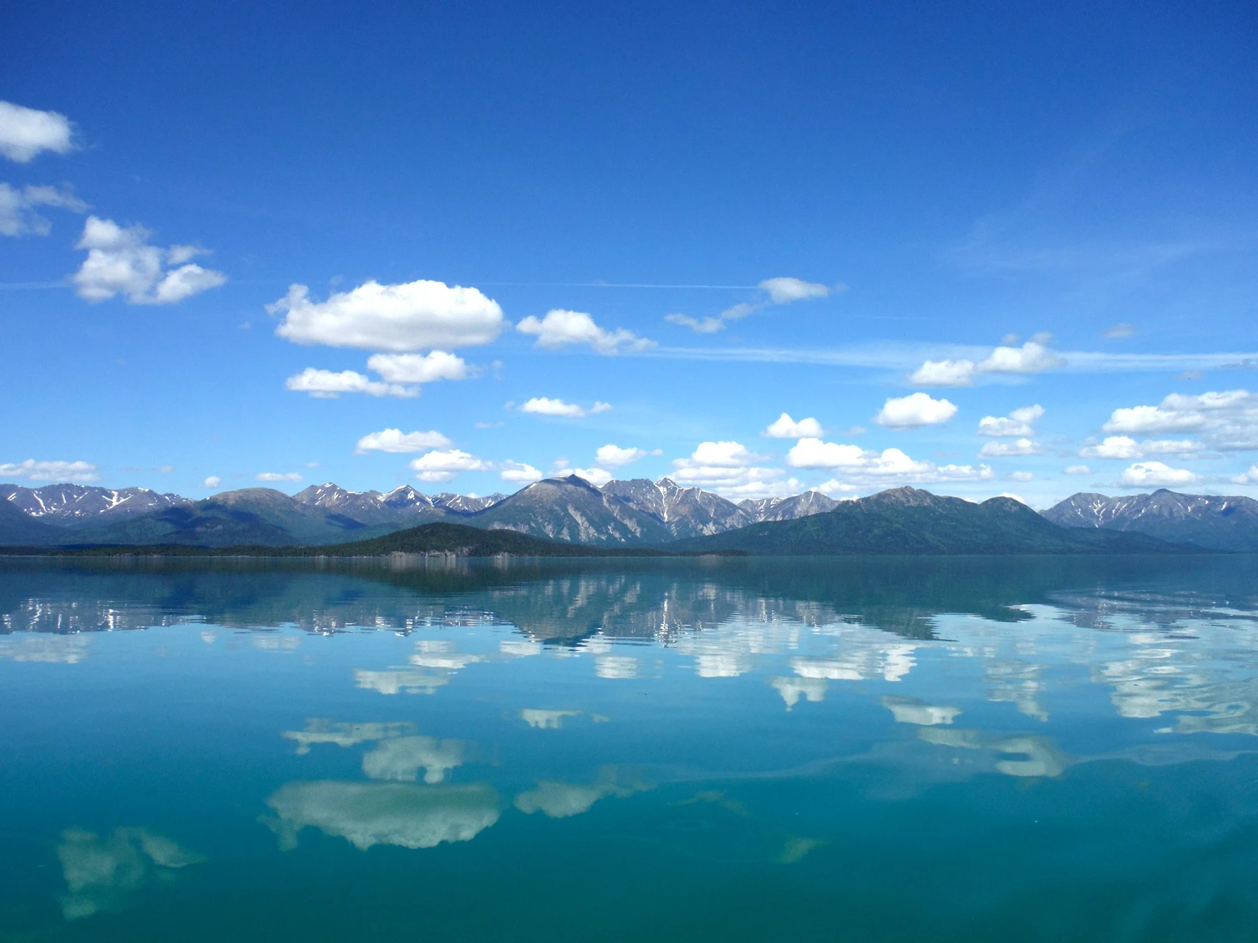
Augie opened his notebook to a blank page and drew a mountain. Then he added a lake, a river, a fish and a second mountain.
“This park ordered every landscape on the menu.”
Andy studied the official photographs beside the map. “Mountains, coast, tundra, forest, volcanoes. Extra fish.”
The family’s next reading adventure led to Lake Clark National Park and Preserve in southwest Alaska. After investigating wolves and moose on Isle Royale, the children were following another set of connections, this time between moving rock, moving ice and traveling salmon.
Their grown-up had planned suitable short experiences and park interpretation. Photographs would help them investigate distant volcanoes, glaciers and fish habitat without pretending they could reach every landscape in one outing. Remote travel depended on weather, local expertise and current guidance.
Allie wrote their question: How do volcanoes, glaciers, rivers, salmon and people connect across this region?
Ana spread out a map and left room for several different drainage routes.
“We’ll need a big diagram. But we shouldn’t connect places just because they fit on one page.”
The park stretched from the Cook Inlet coast across mountain country into inland lake and river systems. Its waters did not all flow to the same place. That was already a useful clue: a park boundary and a watershed boundary were different kinds of lines.
Augie drew a fish beside the volcano. He gave the fish a worried expression.
“Does the salmon have to swim through lava?”
“No,” Andy said. “The title needs some investigating.”
Their title introduced neighboring and connected processes across the park region. It did not mean that one volcano had produced every river or that salmon lived in molten rock.
Augie erased the worried face and added a notebook to the fish.
“Good. Another detective.”
2. A mountain with a deep beginning
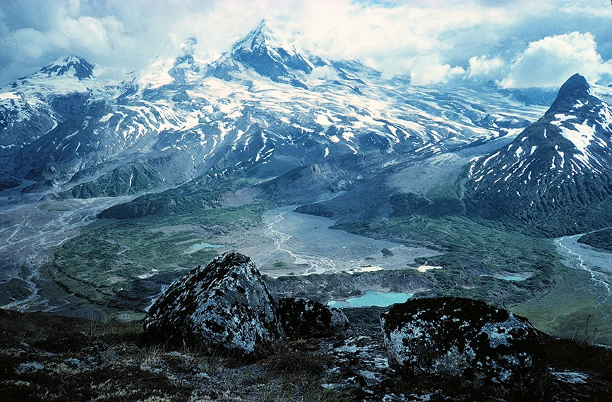
Park information introduced two active volcanoes, Redoubt and Iliamna. Their ice-covered heights belonged to the Alaska–Aleutian volcanic region, where the Pacific Plate descended beneath the North American Plate.
Ana slid one piece of paper beneath another.
“Subduction: one plate moving down beneath another.”
The paper showed the direction of movement, but not the heat, pressure or chemistry deep inside Earth. Their grown-up helped them keep the model’s limits clear.
Water carried downward in minerals and sediments could be released from the descending plate. That water helped lower the melting temperature of hot rock in the mantle above it. Some rock melted, producing magma that could rise toward the surface.
Allie put the water arrow in a different color from the magma arrow.
“So the whole sinking plate doesn’t simply become a river of lava.”
“Correct,” Ana said. “And magma is below the surface. Lava is molten rock that reaches it.”
Repeated eruptions could add layers of lava and broken volcanic material, building and reshaping a mountain. Later ice, water and gravity could modify what those eruptions had made.
Augie looked at the photograph.
“A mountain with more than one construction crew.”
The children did not label every cloud above a summit as an eruption. A photograph could contain ordinary weather clouds, and interpreting volcanic activity required evidence. The Alaska Volcano Observatory monitored the region; the family’s chapter was explaining origins, not reporting today’s volcanic conditions.
Andy drew a magnifying glass beside the summit rather than a warning sign of his own invention.
“We can ask what the mountain is doing. We need the right evidence to answer.”
Allie wrote their first connection: Deep processes can build the land that water and ice later reshape.
3. Useful minerals do not make a harmless eruption
Augie wanted to know what happened to volcanic material after it landed.
“Does the mountain clean up?”
Rain, air, ice and living things could break down and alter rock over time. This weathering helped release mineral ingredients and contributed to the development of soils. Some volcanic material could eventually become part of a growing place for plants.
Andy drew a rock, small particles and a plant on a long timeline.
“Eventually is doing important work here.”
Fresh ash was not ordinary fireplace ash. It consisted of fine particles of volcanic rock, minerals and glass. Falling ash could damage living things and interfere with travel. A deposit that later contributed minerals could still cause serious harm when it arrived.
Ana made two notebook headings: short-term disturbance and longer-term change.
“A useful ingredient later doesn’t erase the earlier damage.”
Eruptions could also interact with snow and ice. Heat could melt ice, and water could mix with loose material, producing dangerous flows of mud and debris called lahars. These were not the same as lava flows, even though both could be associated with a volcano.
Allie drew a separate brown arrow and labeled it carefully.
“No pouring real mud down a hillside to copy that,” their grown-up added. “A paper diagram can do the job.”
The children considered their opening fish drawing. Rivers near volcanoes could be affected by eruptions, but they also had everyday lives between volcanic events. Flow, temperature, sediment, habitat and seasons all mattered to the organisms using them.
Augie replaced his picture of a volcano handing a plant a lunchbox with a question mark.
“Not instant plant food.”
“Right,” Allie said. “The story changes depending on the material, the amount, the place and the time.”
Their diagram was gaining arrows, but each arrow needed a specific explanation. Otherwise a connection could become an exaggeration.
4. Ice is another landscape builder
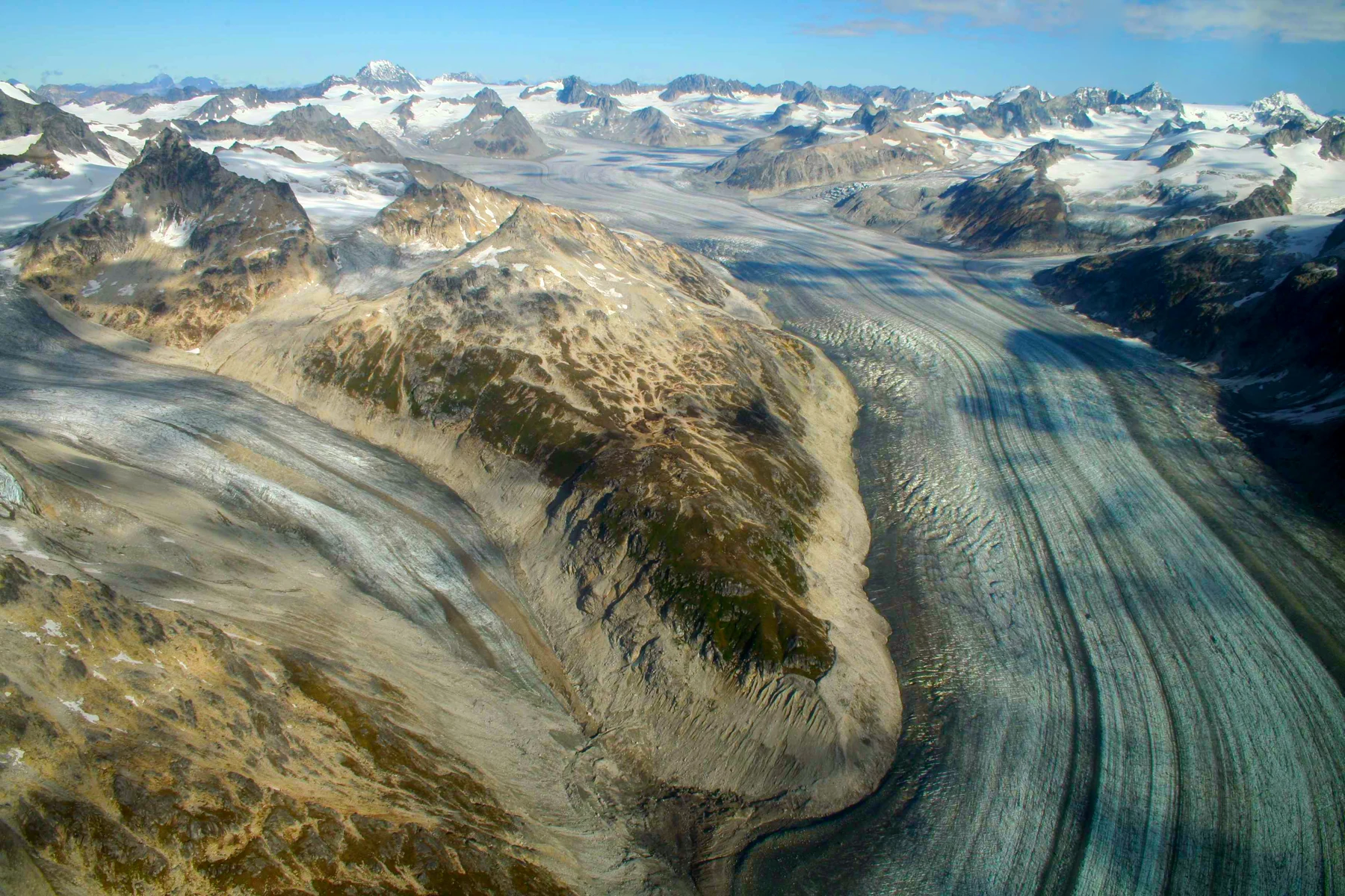
The children turned from volcanic heights to glacier photographs.
A glacier formed where snow accumulated over time, compressed into ice and moved under its own weight. As it moved, ice could carry pieces of rock. Rock fragments at the glacier’s base could scrape the ground, while other processes loosened and removed blocks.
Andy drew scratch marks beneath a blue glacier.
“An enormous sculptor with rocks in its mittens.”
Across long periods, glaciers helped deepen valleys and carve basins. When ice retreated, some low places could hold lakes. The region’s landscape also reflected the rock and mountain structures already there; ice did not create everything from a blank, flat sheet.
Ana added an older mountain outline behind her glacier.
“Several histories in one view.”
Lake Clark occupied a long glacially shaped basin. Snow, rain, streams and glacier-fed waters contributed to the region’s water systems. A glacier could store water as ice and release some through melting, with the amounts changing through seasons and longer-term conditions.
Allie connected stored snow and ice to moving water. Then she added a question about where that water went next.
Augie drew a lid over the lake.
“The mountains made a water bowl.”
“A useful picture,” Andy said. “But the bowl has outlets.”
Fine rock particles carried by glacier-fed water could affect a lake’s color by scattering light. Color varied with particles, water conditions and illumination. A turquoise photograph did not establish that a lake was safe to drink or enter.
The family used images and interpretation for this part of their investigation. They did not walk onto glaciers or cross cold, fast streams to prove that ice and water were powerful.
Ana gave the glacier a second label: sculptor and water store.
Augie added a very large pair of pretend mittens.
5. Follow the outlet, not the park line
Allie traced a route away from Lake Clark on the map.
“If we follow the water, where does the line end?”
Lake Clark connected downstream through Sixmile Lake and the Newhalen River to Iliamna Lake. The Kvichak River carried that system’s waters toward Bristol Bay. Those names gave their diagram a real route instead of one blue arrow marked “ocean.”
Ana wrote the sequence in the notebook. She checked that Iliamna Lake and Iliamna Volcano were not being treated as the same feature.
“Similar names, different map jobs.”
Other waters in the park drained toward Cook Inlet, and still others belonged to other drainage systems. The mountains created divides between places where water traveled in different directions.
Andy folded a paper ridge and traced one arrow down each side.
“A raindrop can land a short distance away and get a different destination.”
A watershed was the area draining toward a shared receiving place or outlet. Small watersheds could fit within larger ones. A stream’s surroundings therefore mattered: land, smaller tributaries, lakes and downstream routes were parts of its connected setting.
Allie drew nesting outlines rather than a fence around a single stream.
“So protecting a fish river can involve places upstream that don’t look like fish habitat.”
Water could carry sediment and other materials along those routes. Natural processes moved some material; human disturbances could change the amount or kind. Not all sediment was bad, but too much fine material in the wrong place could affect habitat, including spaces used by developing fish eggs.
Augie gave his fish detective a sign: Please check upstream.
Their grown-up reminded them that a paper watershed was a model of drainage direction. It could not predict the exact response of a real river to a storm or a change on land.
The children had reached the water’s route. Now they needed a traveler moving the other way.
6. A fish with a freshwater beginning
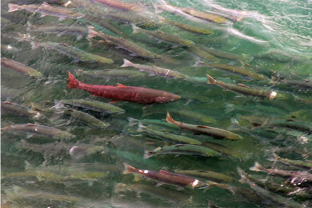
The park’s sockeye salmon story began with eggs in freshwater.
Allie arranged paper cards in a circle: egg, young fish, growing fish, ocean adult and returning adult. She left room for the stages to have their own names and needs.
Young sockeye used freshwater habitat before migrating toward the sea. Many spent part of their early life in lakes. As they prepared for ocean life, changes in their bodies helped them make the transition to saltwater.
Andy added a label: smolt.
“Not just a fish with a tiny suitcase.”
Augie had already drawn the suitcase. He put a question mark on it.
In the ocean, salmon fed and grew. Returning adults moved back toward freshwater spawning habitat, where they would reproduce. Their journeys linked waters that could seem far apart on the family’s map.
Ana used one blue arrow for water flowing downstream and a red arrow for adults traveling upstream.
“The river and the fish do not always point the same way.”
Sockeye returning to reproduce often developed striking red bodies and greenish heads. Their appearance changed through the life cycle, so one spawning photograph did not show every sockeye’s everyday color.
Allie added a silvery ocean-stage fish beside the red spawning adult.
Pacific sockeye died after spawning. Their eggs began a new generation, but not every egg survived to adulthood. Suitable water, oxygen, habitat and food mattered at different stages. Predators, environmental changes and other pressures also influenced survival.
Augie examined the circle.
“A round trip for the story, but not the same fish going around forever.”
“Exactly,” Ana said.
The children learned from park photographs and interpretation rather than entering a spawning stream. Feet, boats or careless handling could disturb habitat. Their family could follow the journey with paper arrows and leave the actual fish to make it.
7. Fish-shaped grocery trucks
Andy looked at their two arrows again.
“Water carries things downstream. What do the returning fish carry upstream?”
Their own bodies were part of the answer. Salmon that had fed and grown in the ocean carried nutrients gathered there back into freshwater systems. After spawning, their bodies could be eaten or broken down by decomposers, making those materials available through other pathways.
Augie drew a salmon with wheels.
“Fish-shaped grocery trucks.”
Ana laughed, then added a careful label: marine-derived nutrients. The fish did not bring packaged soil or feed every plant directly. Nutrients moved through feeding, waste, decomposition and the surrounding food web.
Bears and other animals could carry salmon or pieces of fish away from water. That could move some nutrients onto land. Microorganisms and other decomposers helped break down organic material, and plants could take up nutrients that became available in the soil.
Allie drew several shorter arrows instead of one magical fish-to-tree line.
“Travel, feeding, decomposition, uptake. Different steps.”
Brown bears in the park used varied foods, including plants and, when available, salmon. Their feeding changed with place and season. A photograph of a fishing bear did not mean every bear spent every day catching fish.
The family did not approach bears or stand beside a fishing place to imitate a photo. Their grown-up used current park bear guidance and chose appropriate ways to learn. Food and scented items needed responsible handling, and wildlife needed room to move and feed.
Andy removed a picnic table he had sketched beside his bear.
“We are guests in a very busy grocery store.”
Allie linked the salmon page to the watershed page. Healthy spawning and rearing habitat helped support fish. Returning fish, in turn, could contribute food and nutrients to connected habitats.
Augie took the wheels off his salmon.
“Better at swimming than driving.”
8. A living homeland and a continuing harvest
The children’s diagram contained mountains, water, fish and bears. It also needed the people who had lived within these relationships across generations.
The family learned about the Dena’ina, whose continuing cultural connections were essential to understanding the Lake Clark region. Knowledge of waters, seasons, animals and travel routes belonged to living communities, not merely to an old page in a history book.
Ana added people and relationships beside the whole diagram.
“We shouldn’t save this part for a tiny corner.”
Official interpretation described subsistence: ways of obtaining and sharing food and other resources that supported physical life, family relationships and cultural continuity. Salmon fishing and fish camps were important parts of that story.
Allie wrote down the Dena’ina name used in park interpretation for Lake Clark, Qizhjeh Vena. She kept it beside the source rather than inventing her own translation or pronunciation.
“A place can hold more names and knowledge than the first map we saw.”
Their grown-up helped them distinguish reading about fishing from being authorized to fish anywhere. Subsistence practices, visitor fishing and different park and preserve rules were not interchangeable. Current guidance and community knowledge mattered.
The children did not recreate a ceremony or pretend a community member had told them a story. They learned through the park’s interpretation and left questions open for appropriate sources: How are skills passed on? How does sharing connect households? What responsibilities accompany using a place?
Andy linked the fish-camp page to the salmon life cycle.
“The timing of the fish becomes part of people’s seasonal work.”
Augie looked at his grocery-truck drawing.
“It was missing the people who already know the delivery route.”
Ana added a note about respect. Visitors could learn from a living homeland while recognizing that homes, camps and cultural places were not freely available exhibits. Permission and local guidance belonged in an explorer’s preparations.
9. A diagram with several destinations
At the end of the investigation, the family spread the pages across the table.
Deep Earth processes helped form volcanic mountains. Glaciers helped shape valleys and basins. Rain, snow and melting ice supplied moving water. Drainage routes connected inland habitats to larger rivers and the sea.
Salmon followed their own life-cycle journeys through those systems. Returning adults carried nutrients gathered in the ocean, and other living things moved and reused some of that material. Dena’ina communities held enduring relationships with these places and seasonal resources.
Andy pointed to the separate drainage arrows.
“One park, several watersheds. We almost put all the water in the same bowl.”
Allie returned to their question. They had found real connections without needing every feature to share one direct route. A volcano on one side of the mountains and a salmon system on another could belong to the wider regional story while keeping their own geography.
Augie drew a large menu around his first mountain picture.
“Still every landscape.”
“With the ingredients labeled,” Ana said.
The title The Volcano With Salmon Rivers now made sense as an invitation to investigate Lake Clark’s varied landscapes. It was not a claim that lava became salmon or that eruptions were necessary for every fish to return.
Their grown-up asked which arrow had surprised them most.
Allie chose the salmon’s nutrient journey. Andy chose the plate descending deep below the volcanoes. Ana chose the divide that sent neighboring waters toward different seas. Augie chose the fish that did not need wheels.
They packed their activity supplies and left rocks, fish and cultural objects where they belonged. Their chapter could travel home as observations, drawings and questions.
Next waited Kobuk Valley, where Arctic dunes would offer another puzzle about ice, water and wind.
Augie closed the notebook.
“The mountain made the menu complicated.”
“And following the connections,” Allie said, “made it worth reading.”
Explorer’s notebook
Nine discoveries to keep
- Lake Clark National Park and Preserve includes coast, mountains, volcanoes, glaciers, lakes, rivers and other connected habitats.
- Subduction beneath Alaska helps magma form above a descending plate; the entire plate does not simply melt into lava.
- Weathering volcanic material can contribute minerals over time, while eruptions and ash can cause serious immediate disturbance.
- Moving glaciers erode rock, shape valleys and basins, and store water as ice.
- Lake Clark connects through Sixmile Lake, the Newhalen River, Iliamna Lake and the Kvichak River toward Bristol Bay; other park waters have different destinations.
- Sockeye begin life in freshwater, grow in the ocean, and return to freshwater to reproduce.
- Returning salmon carry marine-derived nutrients that can move through freshwater and land food webs.
- Dena’ina communities have enduring cultural relationships with these waters, salmon and seasonal ways of life.
- A useful connection diagram keeps geography, time, evidence and different kinds of relationships clear.
Five family adventures
- Model the deep beginning. Slide one paper plate-shape below another and draw a separate water arrow rising from the descending plate into hot mantle above it. Add a small area of partial melting and a magma route toward a volcano. Explain that paper movement shows direction, not real temperatures, chemistry or eruption timing. No heat or chemical reaction is needed.
- Make an ice-and-water timeline. Draw a mountain valley, a glacier occupying it, a retreating ice edge and a lake with an outlet. Label what ice could erode and where later water could travel. Keep the drawings as simplified stages rather than a reconstruction of one exact Lake Clark valley. Discuss what the pictures leave out, including changing climate and older rock structure.
- Follow two watersheds. Fold waterproof scrap paper into a ridge inside a washable tray. Add a few drops of water to each side with a grown-up and trace the different destinations. On a separate map, trace Lake Clark’s route through Sixmile Lake, Newhalen River, Iliamna Lake and Kvichak River toward Bristol Bay. Mark Cook Inlet separately. The tray demonstrates direction, not actual river flows or safe travel routes.
- Send a paper salmon on its journey. Make cards for freshwater eggs, young sockeye, a smolt moving seaward, an ocean adult and a returning spawning adult. Use blue arrows for downstream water and another color for fish movement. Add separate nutrient tokens that return with adults, then move through a bear or decomposition card toward land and water food webs. Explain that not every fish survives or takes the same route onto land.
- Build a place-and-people notebook. Read official park interpretation about Dena’ina subsistence and salmon with a grown-up. Record the source, one continuing relationship and one question you still have. Add a guest-care page about permission, wildlife space and leaving places intact. Compare one family food tradition with what you read without pretending the traditions are identical or copying a cultural ceremony.
Four questions for the road
- How can water released deep underground contribute to magma formation without the whole sinking plate melting?
- How do a glacier’s work and a volcano’s work leave different clues in a landscape?
- Why should a park map and a watershed map have different boundary lines?
- What steps connect a salmon growing in the ocean to nutrients becoming available on land?
Eight words for your explorer kit
- Subduction: Movement of one tectonic plate down beneath another.
- Magma: Molten and partly molten rock below Earth’s surface.
- Weathering: Breaking down or chemical alteration of rock where it is exposed to air, water and other influences.
- Glacier: A persistent mass of land ice that moves under its own weight.
- Watershed: An area whose water drains toward a shared receiving place or outlet.
- Smolt: A young salmon undergoing changes that prepare it to move from freshwater toward the sea.
- Marine-derived nutrients: Nutrient materials that come from the sea, including those transported inland by returning salmon.
- Subsistence: Obtaining and sharing food and other resources from the land and water as part of physical sustenance and continuing ways of life.