1. The gate that was made of mountains
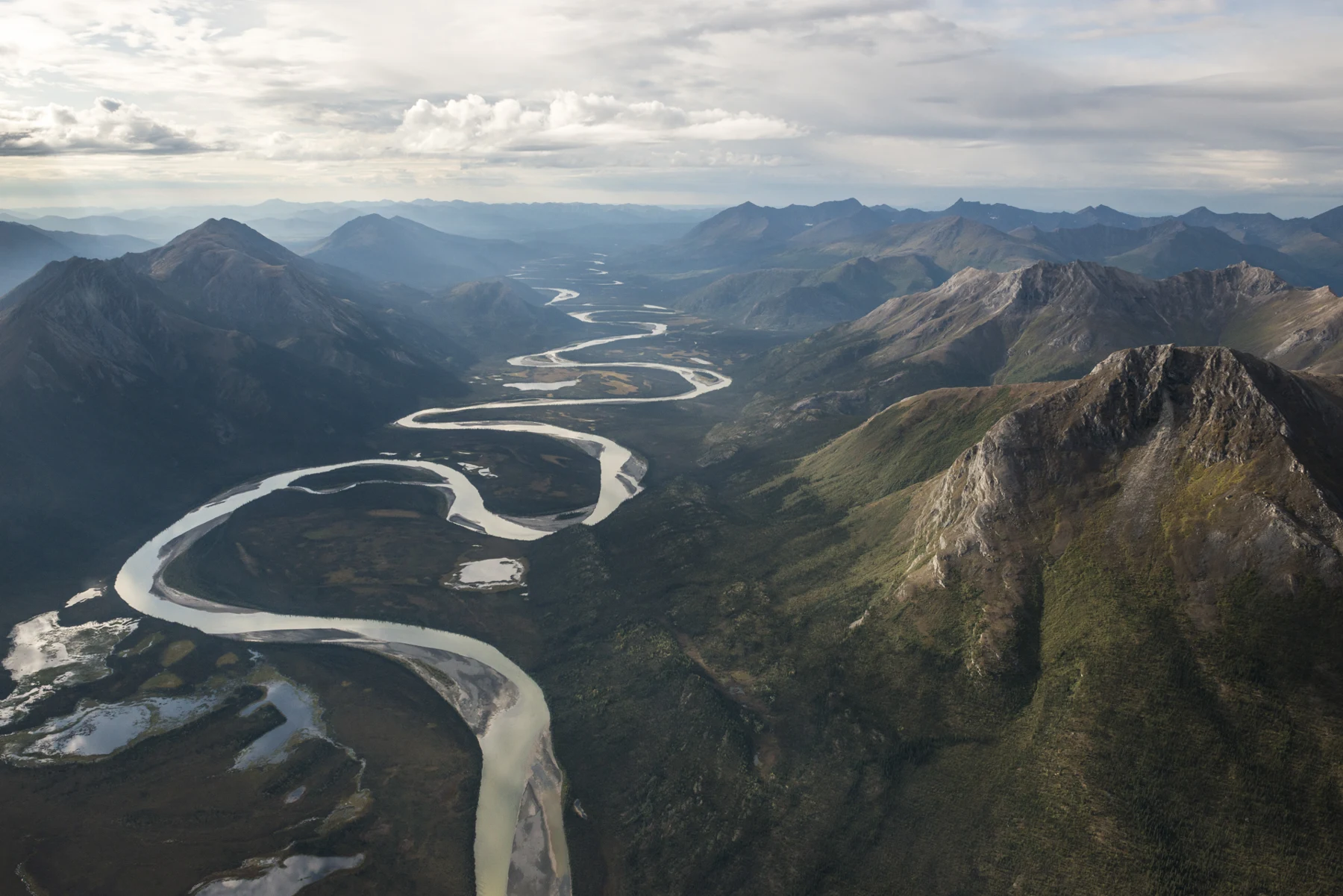
Augie checked the park photograph for a gate.
He found mountains, a river and more mountains.
“Did somebody forget the entrance?”
Andy pointed to the map. “This gate is much bigger than a fence.”
The last chapter of their U.S. National Parks collection led to Gates of the Arctic National Park and Preserve, in Alaska’s Brooks Range north of the Arctic Circle. Frigid Crags and Boreal Mountain stood on opposite sides of the North Fork of the Koyukuk River. Those mountains inspired the park’s name.
Allie wrote both names in the notebook. Ana drew the river between them.
“A gateway in the landscape,” she said.
Their grown-up had arranged appropriate interpretation and carefully chosen experiences. Photographs, maps and seasonal accounts would take their investigation beyond what the family could observe directly. The children were not setting out on an unsupported expedition across remote mountain country.
There were no roads into the park and no established recreational trail system guiding visitors through it. That did not mean the land lacked animal paths, human travel routes or a long human history. It meant a visitor could not expect the usual road-and-trail network.
Augie drew a dotted path across the notebook, then stopped.
“We shouldn’t make up the directions.”
Allie wrote their final park question: How do living things meet the challenges of Arctic seasons, and what does a place without trail signs teach an explorer?
Andy looked at the number on the page: 63.
“The last park chapter.”
Ana placed a fresh sheet behind it.
“Let’s keep some room.”
2. The sun has an unusual schedule
The family began with a globe and a lamp, using a grown-up’s help to make a model of seasonal daylight.
Earth’s axis was tilted. As Earth traveled around the Sun, the Northern Hemisphere leaned toward the Sun during its summer and away during its winter. That changed the duration and angle of sunlight, especially at high latitudes.
Ana kept the globe’s axis pointing in the same direction as she moved it around the lamp.
“The tilt doesn’t flip toward the lamp at every position.”
Andy added a small paper dot in the Arctic. Turning the globe showed how a northern place could remain on the lit side through an entire rotation in part of summer. At another part of the orbit, it could remain away from direct sunlight.
Augie studied the dot.
“The sun has a very unusual work schedule.”
In the Brooks Range, summer brought exceptionally long daylight, including a period when the Sun did not set. Winter brought very short days and periods without sunrise. The exact experience depended on date, latitude and the local horizon. Mountain shadows could matter even when the Sun was above a flat horizon.
Allie drew a mountain beside the little dot.
“A globe helps explain the season. It doesn’t show every valley’s view.”
The family also distinguished daylight from warmth. Long summer days did not remove the possibility of cold, snow or freezing conditions. Weather still depended on more than whether the clock said bedtime.
Andy drew a jacket beside his paper sun.
“My bedtime clock may be confused. My coat should stay prepared.”
Their lamp model did not use a hot bulb or direct eye exposure. A cool light, a ball and a few labels were enough to reveal the main idea.
Augie gave his paper dot a blanket.
“Just in case the dot gets sleepy before sunset.”
3. A short season with a lot to do
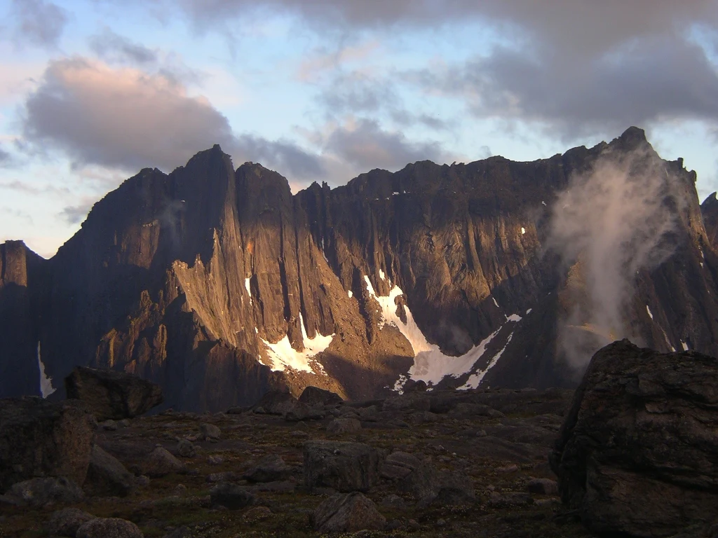
Summer’s opportunity reached across the landscape.
Tundra plants grew, flowers opened and insects became active during a limited growing season. Migratory birds arrived to feed and raise young. Different species used different schedules, but many depended on matching important life stages with available resources.
Allie drew three calendars: a flower, an insect and a bird.
“Timing can connect neighbors.”
A bird needed more than light. It needed suitable habitat and food. Young animals needed energy to grow. Plants needed water, nutrients and temperatures that allowed growth. Long daylight could support these activities without making every part of life easy.
Andy placed a card marked food available beside the bird calendar.
“The sun doesn’t deliver the whole lunch.”
The park included different plant communities. Boreal forest occurred in southern areas, while higher elevations and areas north of the Brooks Range held tundra and other open habitats. The children would not call the entire park treeless simply because one mountain photograph showed no forest.
Ana compared the images.
“One park can have several kinds of growing place.”
Many tundra plants stayed low to the ground, where conditions could differ from those above them. Some grew in compact forms or returned from living parts that survived winter. Such adaptations helped particular plants cope with their surroundings; they were not a single design shared by every species.
Augie drew a plant crouching beneath a gust.
“Small can be a strategy.”
Their grown-up helped them keep the investigation gentle. They could observe and compare photographs without picking flowers, peeling back ground cover or trampling plants to see what grew beneath.
Allie added another calendar, this one for winter survival. A busy summer was connected to the season ahead. Seeds, stored energy, shelter and movement could all matter after the long days faded.
The landscape was using time as carefully as the children used space in their notebook.
4. The ground has another layer
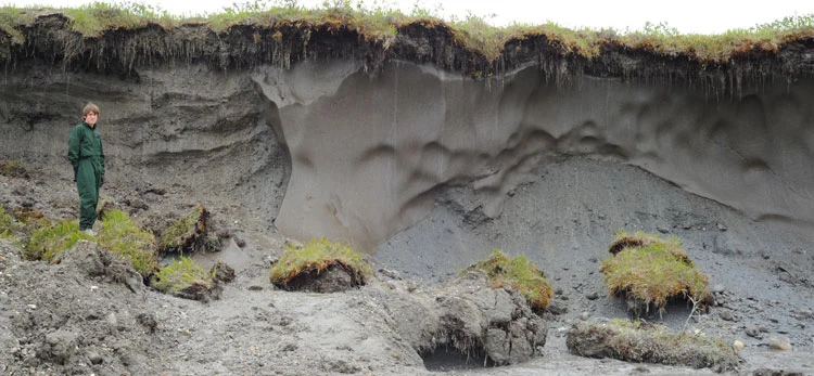
Augie drew a freezer under his tundra picture.
“Is the soil keeping snacks?”
Ana opened the park’s permafrost information. Permafrost meant ground that remained at or below freezing for at least two consecutive years. It could contain soil, rock, ice and organic material. It was not simply another name for snow on the surface.
Allie made a cross-section with separate labels for vegetation, an upper active layer and permafrost beneath.
The active layer above permafrost thawed during the warmer season and refroze during winter. Its depth varied with local conditions. Plants could grow in that seasonally thawed ground, while the frozen layer below influenced roots, water movement and the shape of the landscape.
Andy traced a water arrow near the top.
“If water can’t drain downward easily, the surface can stay wet.”
But the children did not turn all tundra into one giant puddle. Slope, soil, ground ice and drainage routes also mattered. Nearby places could have different moisture conditions.
Augie added a tiny drain to his freezer drawing, then replaced the freezer with the labeled ground layers.
“The real version is more complicated.”
Permafrost could thaw as conditions changed. Where ice-rich ground thawed, the ground could settle or slump, altering drainage and habitat. The name described a long-lasting temperature condition, not a promise that the ground could never change.
Ana wrote persistent does not mean unchangeable beside the diagram.
Scientists monitored ground temperatures, active-layer depths and landforms to learn how these systems changed over time. A family photograph of green tundra could not reveal the temperature of every layer below it.
Allie connected their underground page to the plant calendars.
“What happens beneath the surface can change what grows above it.”
Augie kept one small freezer drawing in the margin.
“For remembering the first question.”
5. Moving, staying and saving energy
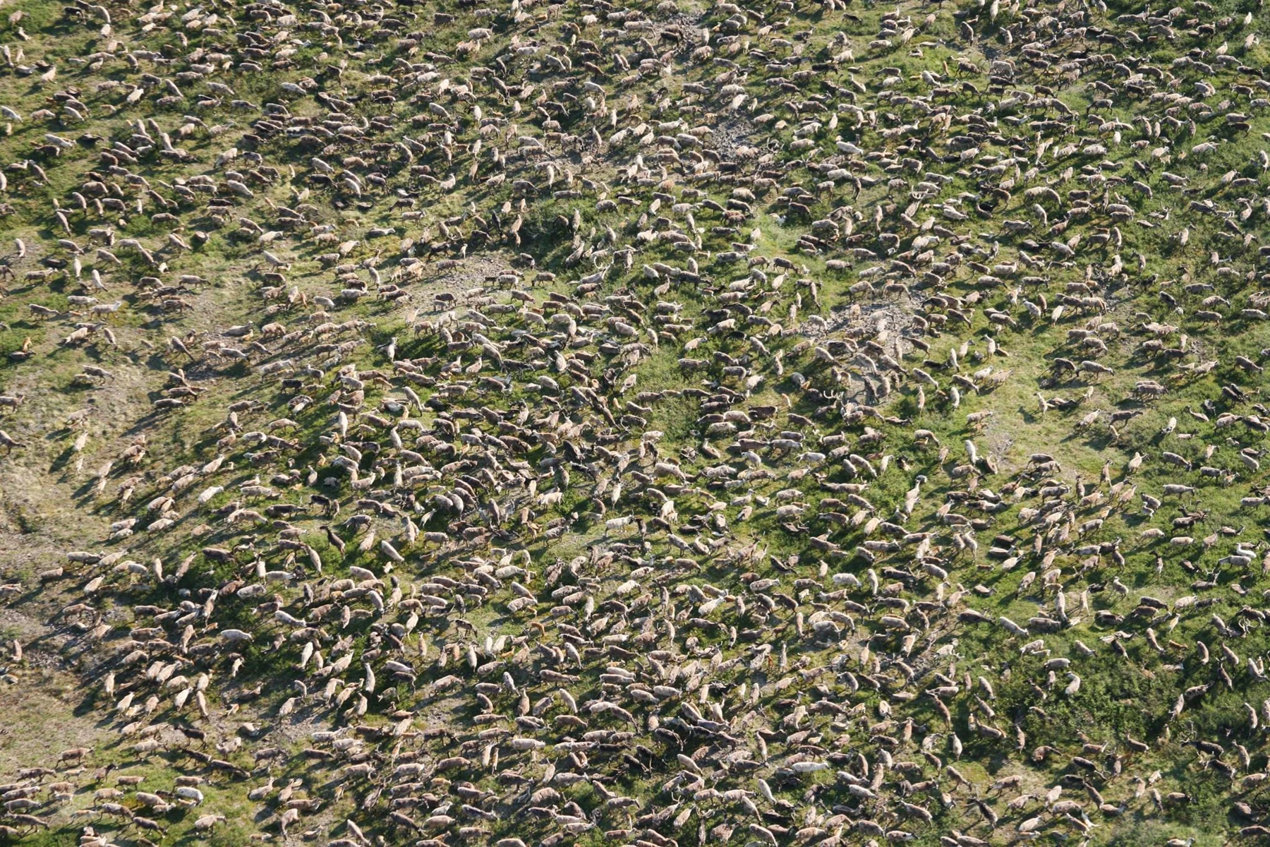
The children returned to the animals in the park’s photographs.
Caribou traveled between seasonal ranges. Their movements helped them reach changing food and places important for calving and summer or winter life. Routes and timing varied with conditions; migration was not one fixed line on a tourist map.
Andy connected this page to their Kobuk Valley chapter.
“The animal’s story can be bigger than one park boundary.”
Other animals met seasonal challenges in other ways. Some birds migrated away for winter. Bears spent the cold season in dens, relying on energy stored earlier. Animals remaining active could depend on insulation, shelter, food choices and movement that conserved energy.
Ana arranged several strategy cards instead of giving every animal a suitcase.
“Leaving is one strategy. Staying needs its own solutions.”
Dall sheep, wolves, moose, bears and many smaller animals belonged to the region’s ecological communities. Their needs and habitats differed. A sheep using mountain terrain and a moose feeding in a valley did not experience exactly the same conditions.
Augie drew a tiny meeting table and tried to seat all the animals.
“This planning meeting needs several rooms.”
Food relationships connected them, too. Predators needed prey. Herbivores needed suitable plants. Insects and other small organisms could become important seasonal food. The children had seen in earlier chapters how changing one relationship could influence others.
Allie added arrows with labels, remembering the food-web work on Isle Royale.
“A useful diagram says what the connection means.”
Their family used interpretation for animals they did not see. They would not pursue caribou, approach a den or move toward a sheep’s slope to fill a wildlife checklist. The animals needed time and space for their own work.
Andy wrote a question beside each strategy card: Where does the energy come from?
That question could travel far beyond the Arctic.
6. Wilderness is a living homeland
The family’s map contained mountains, animals and rivers. It also held human routes, places and relationships that could not be understood by looking for pavement.
Park interpretation described enduring Iñupiat and Koyukon Athabascan connections. The Nunamiut Iñupiat community of Anaktuvuk Pass lay within the park. Living communities continued to draw on knowledge of animals, weather, land and seasons.
Allie wrote homeland beside the word wilderness.
“One word doesn’t cancel the other.”
People had traveled through and lived in this region across many generations. Hunting, fishing, gathering, sharing and learning connected families with the resources around them. Subsistence involved cultural relationships and responsibilities as well as food.
Ana looked back at the title.
“No established park trails does not mean nobody knew a way through.”
Their grown-up helped them distinguish the absence of a visitor trail network from the presence of deep local knowledge. A paper map alone did not contain every observation, place name or seasonal understanding held by people who knew the region.
Andy added learn from appropriate sources to the explorer checklist.
The children did not invent a community conversation or imitate a ceremony. They read park interpretation, kept track of who published it and wrote respectful questions. What guidance should guests follow? Which places needed permission? How were skills shared between generations?
Augie drew a speech bubble with May I? inside it.
“That question still fits.”
Archaeological and historical traces also deserved care. Their locations and relationships held information. The children would leave objects and places intact, respect homes and working areas, and understand that open-looking land did not make every place freely available to enter.
Allie connected this page to the rest of their collection. Again and again, learning about a landscape had also meant recognizing whose home it was and how to be a thoughtful guest.
7. A map asks you to think
Andy unfolded a topographic map.
“There may be no trail signs, but the map has lines.”
Contour lines joined places of equal elevation. On a map using the same contour interval, closely spaced lines showed a steeper slope than widely spaced ones. The children practiced on a simple invented hill drawn on paper.
Ana moved a paper traveler across it.
“Crossing five close lines changes height quickly over a short distance.”
The model helped them read the picture. It did not make them ready to navigate remote mountain country. Actual route choices involved terrain, vegetation, weather, river conditions, skills and information beyond one contour diagram.
Allie wrote a clue, not a guarantee beneath the hill.
A river valley might look like an obvious route, but water levels and currents could change. A stream shown as a thin blue line could be difficult or dangerous to cross. The family would not treat a caribou route or a photograph as human travel instructions.
Augie drew one granola bar beside a mountain, considered the picture, and added a much larger planning notebook.
“This is not a one-snack expedition.”
Their grown-up discussed why experienced preparation mattered: navigation skills, suitable equipment, dependable communication and current park and local guidance. A device could help, but batteries and signals could fail. Remote help could take time.
For their chapter, the children could practice map ideas in a safe setting and use official interpretation to explore the wider park. Curiosity did not require pretending they had completed a difficult journey.
Andy looked at the blank space beyond his invented hill.
“What if we don’t know enough?”
“Then finding out is part of the adventure,” Allie said. “And sometimes changing the plan is the right discovery.”
Ana added that to the checklist. It would be useful wherever the four went next.
8. Sixty-three places, a traveling explorer kit
The children spread their older notebook pages around the final park map.
There were rivers carving rock, forests catching moisture, animals connecting plants, caves shaped by water and islands carrying stories far below the sea. Their U.S. National Parks collection held sixty-three different invitations to notice.
Augie tried arranging every drawing in one straight row.
“The table needs to be a continent.”
Allie suggested a different way to pack. Instead of choosing one favorite fact to explain everything, each child could choose a habit they wanted to carry into the next collection.
She chose ask a clear question. A good question had helped turn a pretty view into an investigation.
Ana chose look for evidence and listen. They had learned from observations, maps, photographs, research and the people whose knowledge belonged to a place. Knowing where an explanation came from helped them understand what it could and could not tell them.
Andy chose follow the connections. Rock, water, weather, plants, animals and people kept influencing one another, often beyond the edge of the first picture.
Augie thought for a long time.
“I choose snacks.”
Their grown-up nodded. “Useful. What else?”
“Leave room for another question.”
Ana drew four pockets on a paper explorer kit. They added care, preparation and the courage to change an idea when new evidence arrived. Those belonged with every pocket.
The kit did not need a national park sign to work. The next collection might begin somewhere nearby or far away, with a place, a person, an invention or a mystery they had never considered. Its name and destination could wait until the four were ready to choose.
Allie placed a blank page beside the Arctic map.
“Different adventures can ask for different tools. These habits can come with us.”
Augie drew a pencil at the top.
“And this one still has an eraser.”
9. The next page is waiting
At last, the family returned to the two mountains that had begun the chapter.
The gates did not mark the end of everything beyond them. They framed a passage into a wider landscape.
Andy traced the space between the peaks.
“That is a good kind of last picture.”
They could now answer their Arctic question. Seasonal sunlight helped shape the opportunities and limits of the year. Plants and animals met those conditions through timing, growth, shelter, stored energy and movement. Frozen ground influenced water and habitat. People’s knowledge and enduring relationships belonged throughout the story.
Allie wrote the final park discovery beneath the map: Understanding a place means noticing its seasons, its connections and the lives already woven through it.
The U.S. National Parks collection was complete. Sixty-three chapters could remain on the shelf to revisit, reread and share. Finishing them did not mean the family had learned everything about the parks, or that curiosity had reached its last destination.
Ana opened the fresh notebook page.
At the top she wrote: What shall we discover next?
There was no destination underneath it yet. No particular country, subject or kind of trip had to be chosen that evening. Their next collection would have its own questions and its own beginning.
Andy placed his map beside the new page. “We can start with something we notice.”
“Or something we wonder about,” Allie said.
“Or something that looks ordinary,” Ana added, “until we look again.”
Augie peered under the blank sheet.
“I am checking whether the next adventure is hiding here.”
Their grown-up smiled. “What would you do if it were?”
“Ask it a question.”
All four laughed. Then Allie made room for the reader beside their drawings.
“You can bring a question too.”
They packed away the national park pages carefully, keeping them ready for another visit. Their final Arctic map went beside the first page of the collection, a reminder of how far a question could travel.
The new page stayed open. Allie, Ana, Andy and Augie were still together, still ready to explore, discover, learn and have fun.
Augie set his pencil across the empty space.
“Ready when we are.”
And wherever their next collection began, they would begin the same way: by noticing something, asking a question and making room for the answer to surprise them.
Explorer’s notebook
Nine discoveries to keep
- Frigid Crags and Boreal Mountain frame the river passage that inspired the name Gates of the Arctic.
- No road-and-trail network does not mean a place lacks human history, local knowledge or animal routes.
- Earth’s tilted axis produces large seasonal daylight changes at Arctic latitudes.
- Long summer daylight does not guarantee warm weather; plants and animals still depend on suitable conditions and resources.
- Permafrost is ground remaining at or below freezing for at least two consecutive years, with a seasonally thawing active layer often above it.
- Frozen ground and its changes can influence drainage, vegetation and habitat.
- Migration, insulation, shelter and stored energy are different ways living things meet seasonal challenges.
- Iñupiat and Koyukon Athabascan relationships, including the Nunamiut community of Anaktuvuk Pass, are part of the living region.
- The national park collection is complete, while asking questions, following evidence and caring for places can continue into any next adventure.
Five family adventures
- Model the daylight. With a grown-up, use a cool lamp and a marked ball or globe. Keep the axis tilted in the same direction as you move it around the lamp. Turn the globe and follow a northern dot through light and darkness at two opposite positions. Explain that the model shows seasonal geometry, not actual temperatures, local mountain shadows or precise daylight dates.
- Draw the ground below. Make a paper cross-section with surface plants, an active layer and permafrost beneath. Draw summer and winter versions. Add arrows for possible water movement and discuss why slope, soil and ground ice can change the outcome. Label it a simplified model; no digging, thawing experiment or disturbance of living ground is needed.
- Pack an animal strategy kit. Make cards for migration, insulation, shelter, stored energy and finding food. Match them to animals introduced in the chapter, allowing more than one strategy for an animal. Ask what evidence would help check each match. Use photographs and books rather than approaching wildlife or searching for dens.
- Read a paper hill. Draw an invented hill with equally spaced elevation values on its contour lines. Place some lines close together and others farther apart, then compare the slopes. Add a river and discuss what the drawing cannot tell you about safe crossing or current conditions. Keep this a map-reading activity, not a route plan for remote travel.
- Open the next-collection page. Each family member chooses one discovery from these sixty-three chapters and one question about anything they would like to investigate next. Make four pockets labeled ask, observe and listen, connect, and care. Place the questions in them, then leave the destination blank. Add a note about one way to learn respectfully from the people or sources connected with the future subject. You can choose the next adventure together when you are ready.
Four questions for the road
- Why can Arctic summer bring very long daylight and still require preparation for cold conditions?
- How might a change beneath the ground affect water and plants above it?
- What knowledge is missing if a visitor sees “no trails” and assumes “no human story”?
- Which explorer habit will you carry into the next collection, wherever its questions lead?
Eight words for your explorer kit
- Axis: The imaginary line about which Earth rotates.
- Latitude: Position north or south of the equator, measured in degrees.
- Tundra: A cold-region plant community with low-growing vegetation and no continuous tree canopy.
- Permafrost: Ground at or below freezing for at least two consecutive years.
- Active layer: Ground above permafrost that thaws and refreezes seasonally.
- Adaptation: An inherited feature that helps organisms survive or reproduce under particular conditions.
- Contour line: A line connecting places of equal elevation on a map.
- Curiosity: The desire to ask, investigate and learn, with room for discoveries that change what you think.