1. The trail has gone swimming
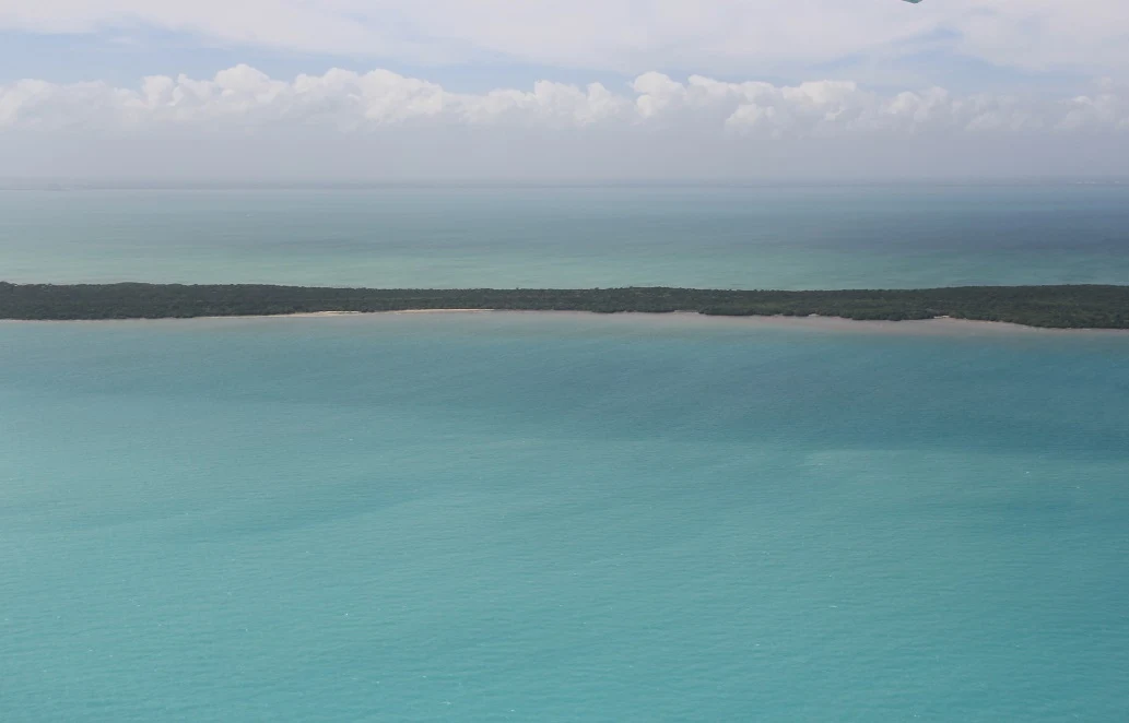
Augie arrived at Biscayne National Park carrying the notebook that had investigated Kings Canyon. On its first clean page, he had drawn a pair of boots.
“For the next trail,” he explained.
Beyond the mainland shore, blue-green water stretched toward distant islands. No mountain rose above it. No canyon opened beneath their feet. A breeze turned a page and nearly sent the boots on their first flight.
Andy held the notebook shut. “I think the trail has gone swimming.”
Allie looked across the bay. “Our challenge is to map a park when most of it is water.”
They were in southern Florida, near Miami, a very different place from the Sierra Nevada. About ninety-five percent of Biscayne National Park was covered by water. That did not mean the watery part was empty space between the interesting bits.
“It means our eyes are mostly seeing the roof,” Ana said.
“Does the roof leak?” asked Augie.
“Constantly,” said Andy. “Terrible building.”
At the Dante Fascell Visitor Center, the family studied park exhibits and photographs. Their grown-up had planned a mainland visit, with time to look carefully at the shoreline. They would investigate distant islands and reefs through pictures rather than pretend that every part of the park lay a short walk away.
Allie divided a page into four spaces: mangrove shore, bay, islands and coral reef. These were the park’s four main ecosystem settings. An ecosystem included living things and the water, light, soil or rock around them.
“Four separate parks?” Andy asked.
“One connected park,” Ana replied. “But we need evidence for the connections.”
Augie drew a tiny front door on the water.
“We should knock.”
“We can start by looking,” Allie said.
Their mystery had a title: The Park Under the Water. Their first question was smaller and trickier: how could a tree on the shore belong to the same story as a fish on a reef?
2. The trees with underwater rooms
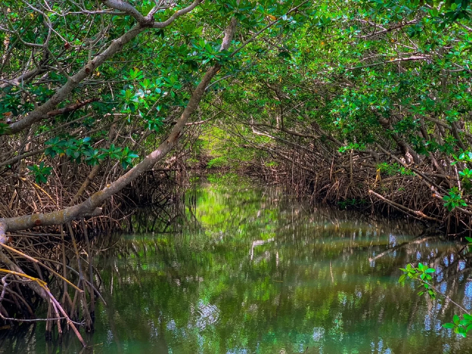
In a park photograph, mangrove branches reached over a still green channel. Roots curved down toward the water like the legs of a very crowded table.
“Nobody could put chairs under that,” Andy observed.
“Maybe the chairs are fish,” said Augie.
Allie traced the roots in the picture with her finger, without touching the screen. Red mangroves grew prop roots that supported them in shallow coastal places. Mangroves were trees adapted to salty surroundings, although different kinds managed salt in different ways.
Ana drew a root arch. Then she drew a small fish beneath it and a larger fish outside.
“A place to hide,” she said.
The root tangle provided shelter for young fish and other small animals. It was not a locked nursery that guaranteed safety. Predators could still hunt there. But a complicated space offered different opportunities from open water.
“Root-shaped cribs,” Augie said.
Andy added a sign to the drawing: No bedtime stories about sharks.
There was more to the tree’s work. Mangroves slowed water movement, allowing some sediment to settle. Their fallen leaves broke down and entered food webs. Tiny organisms used that material; other animals ate those organisms.
“A leaf can keep being useful after it falls,” Allie said.
Augie studied a leaf resting on the path. “Retirement job.”
They left it where it belonged. The family stayed on the established route, without climbing into roots or reaching into water to collect a creature for a closer look.
Ana put the first arrow on their map. It led from a mangrove leaf toward a tiny animal, then toward a fish.
“That arrow means food,” she said. “We should label our arrows so they don’t all mean different things by accident.”
Andy nodded. His arrows sometimes meant look here, walk here or this sandwich is mine. Science would need a clearer system.
3. A lawn without a lawn mower
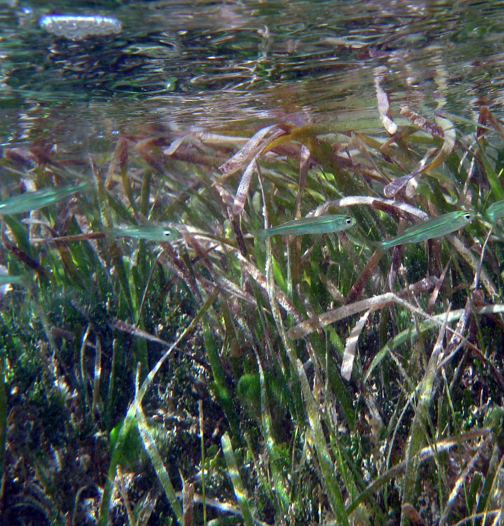
Their next photograph showed long underwater leaves. Light shimmered at the surface above them.
Augie recognized the problem immediately. “Who mows the underwater lawn?”
“A very determined gardener with a snorkel,” Andy suggested.
Ana shook her head. “Seagrass isn’t a garden waiting to be tidied.”
Seagrasses were flowering plants adapted to life under water. They had roots and leaves; they were different from the seaweeds people often grouped together in beach drawings. Biscayne’s seagrasses included turtle grass, manatee grass and shoal grass.
Allie liked the names. “They sound like three neighbors who share a mailbox.”
“And never agree about mowing,” said Andy.
The leaves made places for small fish and invertebrates to shelter. Some animals ate seagrass itself. Other animals ate the tiny organisms living on its leaves. A meadow could support a busy food web without every resident eating the same thing.
Augie drew a menu with three sections: leaf, things on leaf, things eating things on leaf.
“That last section needs a bigger plate,” Ana said.
Roots and underground stems helped stabilize the bottom. Seagrass beds also helped trap particles, supporting clearer water. Sunlight mattered to these plants, so a change in water clarity could affect what happened below the surface.
Allie returned to the map. Mangroves and seagrass both belonged to the story of shelter, food and sediment, but they were not doing identical jobs in identical places.
“We shouldn’t color the whole bay green and call it finished,” she said.
Biscayne Bay also contained other bottom communities. A dark patch seen from far away was a clue to investigate, not a promise that the children could identify it correctly from shore.
Ana wrote learned from the photograph and park information beneath their seagrass drawing.
“Excellent lawn,” Augie decided. “Excellent no-mowing policy.”
4. A boat can leave a footprint
Andy drew a boat above the meadow. Then he drew an enormous boot underneath it.
“A boat footprint,” he announced.
Allie laughed, then stopped. “Actually, boats can leave marks on the bottom.”
They studied information about seagrass restoration. In shallow water, a boat’s propeller could cut into a meadow and damage the plants and their underground parts. A grounding could cause more harm. The scar might remain long after the boat had gone.
Augie looked offended on behalf of the grass. “The boat should wipe its feet.”
“Better to avoid hitting the meadow at all,” Ana said.
Their grown-up explained that safe boating involved much more than seeing blue water and heading toward it. Charts, depth, marked routes, weather, equipment and careful decisions mattered. A map on a visitor-center wall was useful for learning about habitats; it was not a navigation chart for operating a boat.
Andy crossed out the boot and drew a question mark beside the propeller.
“How long does grass take to grow back?” he asked.
There was no single timer that worked for every scar. Damage, conditions and the plants involved all mattered. Scientists monitored places over time rather than judging recovery from one quick look.
“So green water doesn’t prove healthy grass,” Allie said.
“And one good photograph doesn’t tell the whole history,” Ana added.
They remembered the glacier comparisons at Kings Canyon. A careful comparison needed dates, places and a clear idea of what was being measured.
Augie drew a little calendar beside the meadow. It had no deadline, only the words keep checking.
Andy added a second kind of arrow to their map, this time labeled possible damage. A connection could carry help, harm or information. The arrow needed a reason.
5. Yesterday’s reef, today’s island
An aerial photograph showed Elliott Key as a long green strip between areas of blue water. The children could see the island’s outline much more clearly from this viewpoint than from the mainland.
“That photographer had a better seat,” Andy said.
“We can borrow the view,” Allie replied. “We can’t borrow wings.”
They learned that Elliott Key’s foundation included ancient coral reef limestone formed when sea level was higher. The island’s rocky beginning connected it to a reef story, although the forest on top was very much a land habitat.
Augie considered this. “Coral learned to be land.”
“The living animal didn’t decide to become an island,” Ana said. “We’re looking at old reef material and a changing landscape.”
At Kings Canyon, they had separated the making of granite from the later carving of a valley. Here, too, the rock and the landscape needed more than one page of history.
Allie drew water above a patch of reef, then another small picture showing limestone exposed above the water. She labeled it a simple comparison, not every step.
“A comic strip can help us ask questions,” she said. “It can also leave a lot out.”
The islands supported plants and animals above the surface. Mangroves grew near shore; tropical trees grew farther inland. The islands helped shelter the bay from the open ocean.
“So the dry bits are part of the watery story too,” Andy said.
Human stories belonged here as well. Park information described Tequesta fishing and hunting camps, later island communities and other people whose lives depended on these waters. The park’s story had begun long before its national park signs.
Augie added a person with a notebook to the island drawing.
“Us?” asked Ana.
“People asking questions,” he said.
That was a useful addition. People could learn from the park, change it and help care for it. They belonged on the connection map.
6. The rock that is an animal neighborhood
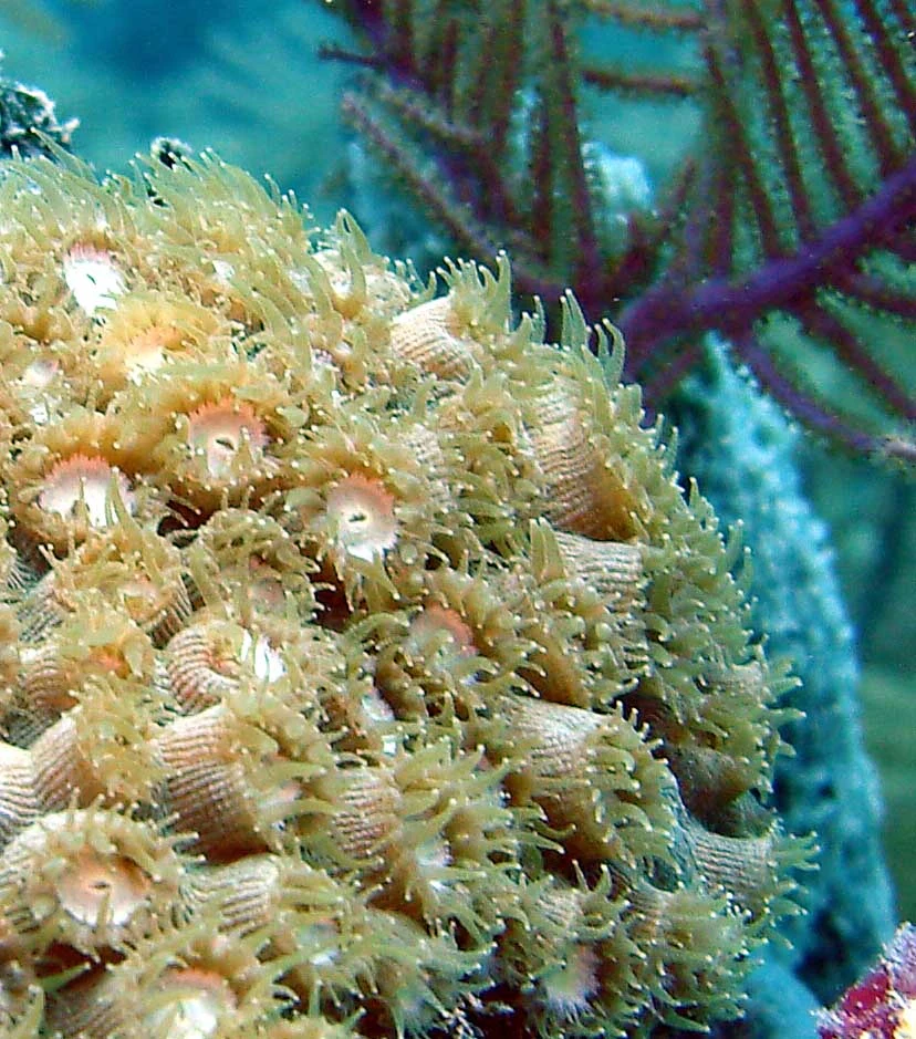
The reef photographs made Andy lean closer. There were ridges, branches, little openings and shapes that seemed halfway between a garden and a stone city.
“Which part is the coral?” he asked.
“Let’s start smaller,” Allie said.
A close view showed coral polyps with tentacles extended. A polyp was an animal. Many reef-building corals consisted of colonies of these small animals living together. Stony corals made hard calcium carbonate skeletons; over generations, those skeletons contributed to the reef’s structure.
Augie stared. “Tiny builders. Enormous neighborhood.”
“And no tiny cement mixer,” Andy added.
The hard framework and the living tissue were different things. Calling coral simply a rock missed the animals; calling the whole reef one animal missed the many kinds of organisms living there.
Ana drew a house and a resident. “The building isn’t the same as everybody inside it.”
Many shallow-water reef-building corals had microscopic algae living in their tissues. The algae used sunlight in photosynthesis and supplied food to their coral partners. Coral provided a protected place and materials the algae could use.
“Roommates,” said Andy.
“A partnership,” said Allie. “But not roommates who take turns washing plates.”
Coral polyps also captured food with their tentacles. Being attached in one place did not make them plants. The children had to investigate how something lived, rather than decide from its silhouette.
Augie drew a coral colony wearing a sign: Animal neighborhood. Please observe politely.
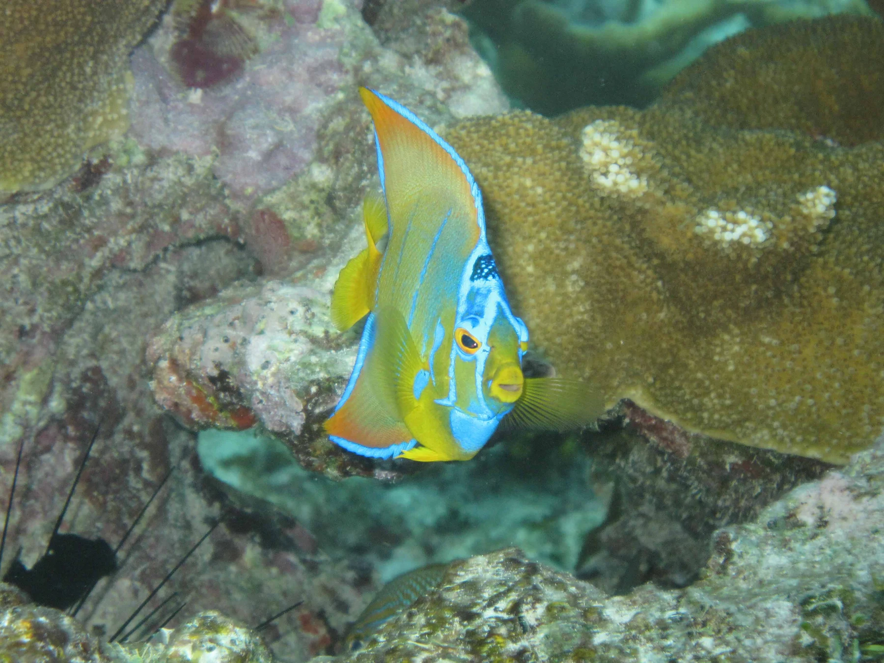
A second photograph showed a queen angelfish among reef life. Its bright colors caught their attention, but Ana pointed to the spaces around it.
“The fish needs somewhere to live, not just somewhere to look colorful.”
They were seeing a place with hiding spaces, feeding places and many different residents. The underwater park was becoming much less empty on their map.
7. When the neighborhood loses color
The children compared reef pictures with park explanations. Some corals looked pale or white. Others had rich colors. Ana did not label them healthy or dead just by choosing her favorite color.
“We need to know what happened,” she said.
Under stress, corals could lose the algae living in their tissues. The white skeleton then showed through more clearly: coral bleaching. Unusually warm water was an important cause, although other stresses could also trigger it.
Augie frowned. “Did somebody wash the color off?”
“No soap,” Allie said. “A living partnership is in trouble.”
A bleached coral was not automatically dead. If conditions improved soon enough, it might recover. If stress continued, the loss of its major food partnership could contribute to its death.
Andy looked at the colorful drawing he had just made. “So we shouldn’t fix the picture with a brighter pencil and call the reef fixed.”
“Exactly,” said Ana.
Heat, disease, pollution and physical damage could affect reefs in different ways. A beautiful underwater photograph showed a place at a moment; it did not promise that every reef would look like that on a future visit.
The children could still enjoy the photographs. Knowing what they showed made them more interesting, not less. A close view of living polyps was evidence of animals doing their work, rather than decoration behind a fish.
Allie added a third kind of arrow to the map, labeled needs sunlight. It pointed to the seagrass and to the algae living with many shallow-water corals.
“One need can connect very different living things,” she said.
Augie considered his own needs and drew an arrow toward the picnic bag.
Ana read his label: needs crackers.
“That connection,” she said, “has been well documented.”
8. Four pictures need more than four boxes
At a table, the family laid out four habitat drawings. Andy tried pushing them into a neat row.
“Mangrove. Bay. Island. Reef. Finished.”
Allie shook her head. “We’ve named the boxes. Where are the connections?”
They added arrows for food, shelter and moving water. Some animals used different habitats during different parts of their lives. Water and the materials it carried did not stop neatly at the edges of the children’s drawings.
“We shouldn’t draw every fish traveling through every box,” Ana said.
“Even the fish don’t have to complete our worksheet,” Andy agreed.
The point was that habitats could support one another without being identical. Damage to one place could matter beyond that place. Protecting a reef involved more than admiring the coral itself; the surrounding water and connected habitats mattered too.
Their grown-up asked what the family could do with this information.
“Keep rubbish from becoming ocean rubbish,” Augie said, holding down a wrapper before the breeze could borrow it.
“Observe wildlife without feeding or chasing it,” said Ana.
Allie added that visitors should never stand on, touch or break coral. Boaters needed to avoid damaging the bottom and follow park guidance about anchoring and moorings. Their family’s mainland visit also had boundaries: stay on the route and leave roots, shells and animals where they belonged.
“We can learn without taking the neighborhood apart,” Andy said.
The map now looked rather untidy. Arrows crossed. Labels ran around the edges. Augie’s crackers occupied a suspiciously large corner.
Ana placed a key beneath it: solid arrows for food relationships, dotted arrows for movement, question marks for things to investigate.
“Much better,” she said.
“Still not a boating chart,” their grown-up reminded them.
“Definitely not,” Andy agreed. “It would send us straight to the crackers.”
9. The park was never missing
Before leaving, the children looked across Biscayne Bay again. From the mainland, much of the underwater world remained hidden. The view had not changed into a transparent window just because they had learned something.
Their questions had changed instead.
At first, Augie had wanted to know where the trail had gone. Now he wanted to know which creatures were sheltering among roots, which plants could grow below the surface and how a tiny animal helped build a reef.
“Did we see all of those things here?” Allie asked.
“No,” Ana said. “We observed the shore and the water. We learned about distant places and underwater life from photographs and park information.”
Andy added three labels to their notebook: observed, learned, still wondering. The same detective habit had traveled from Kings Canyon to the coast.
“What solved our mystery?” he asked.
“The connections,” Allie answered. “A park can include things we can’t see from where we stand.”
The roots, meadows, islands and reefs were not four separate houses with locked gates. They were parts of a larger living neighborhood. A useful map needed relationships as well as outlines.
Augie returned to his original drawing of boots. He put a small fish beside them.
“For the underwater trail?” Ana asked.
“For the fish,” he said. “The boots aren’t invited.”
Next in their park order was Pinnacles, where they would investigate rocks connected to an ancient volcano and a landscape that had moved over a very long time.
“First a park under the water,” Andy said. “Next, rocks with travel plans.”
Allie closed the notebook before the breeze could turn it into a flying park map.
The park had never been missing. They had simply needed to look beyond the surface—and ask what the water connected.
Explorer’s notebook
Nine discoveries to keep
- Biscayne National Park is in southern Florida, near Miami, and about ninety-five percent of it is water.
- Its main ecosystem settings include mangrove shore, Biscayne Bay, islands and coral reefs. Living things interact with their physical surroundings.
- Mangrove roots shelter small animals; fallen leaves enter food webs, and the trees help sediment settle.
- Seagrasses are underwater flowering plants. Their meadows provide habitat and help stabilize sediment.
- Boat propellers and groundings can damage shallow seagrass. Recovery requires time and suitable conditions.
- Elliott Key includes ancient coral reef limestone. Its land habitats are connected to the surrounding water.
- Coral polyps are animals. Many reef-building corals live in colonies and contribute hard skeletons to reef structure.
- Many shallow-water corals depend on a partnership with microscopic algae. Bleaching signals stress; it does not always mean the coral is already dead.
- Food, water and animals connect habitats. Caring for the whole neighborhood helps protect its many residents.
Five family adventures
- Build a connection map: Draw mangroves, a seagrass meadow, an island and a reef on four cards. Add labeled arrows for food, shelter or moving water. Include one question mark for a connection you want to research. This is a learning map, not a boating chart.
- A surface with a secret: Put a drawing of an underwater habitat beneath a sheet of blue paper. Lift one corner, then uncover the whole drawing. Describe what the first small view could and could not tell you. The paper models a limited viewpoint, not the way real light travels through water.
- Roots and settling: With a grown-up, compare two small clear containers holding equal amounts of water and a little clean sand. Add a bundle of clean yarn to one as pretend roots. Stir each gently the same number of times, let them settle and compare. Explain that yarn is not a living mangrove and this small model cannot reproduce a coast. Keep the sand out of drains and waterways.
- Animal, plant or question mark? Draw a coral polyp, a seagrass plant and a fish. Add a fact about how each gets food or uses its habitat. Put a question mark beside anything you cannot identify confidently. Check a reliable nature source together rather than guess from shape alone.
- Keep the picnic on land: Before a family picnic, plan how to secure wrappers, lids and lightweight belongings. At the end, check your space with a grown-up. Never reach into water, roots or hidden places for litter; leave sharp or unsafe objects for an adult to handle appropriately.
Four questions for the road
- How can a tree growing beside the water help animals that live in the water?
- Why is a seagrass meadow more than an underwater lawn?
- How can coral be an animal while also helping build a hard reef?
- Why would protecting only one habitat leave gaps in the care of Biscayne’s connected neighborhood?
Eight words for your explorer kit
- Ecosystem: Living organisms interacting with one another and with their physical surroundings.
- Mangrove: A tree or shrub adapted to tropical or subtropical coastal environments with salty water.
- Seagrass: A flowering plant adapted to living submerged in seawater.
- Sediment: Loose particles, such as sand or silt, that can move and settle.
- Limestone: A rock made mainly of calcium carbonate; ancient reef material contributes to some island limestone.
- Polyp: The individual animal body form found in corals, with a mouth surrounded by tentacles.
- Symbiosis: A close relationship between different kinds of organisms; the coral–algae partnership benefits both partners.
- Bleaching: Loss of a coral’s microscopic algal partners or their pigments, making the coral look pale and indicating stress.