1. A volcano with no suitcase
Andy had drawn a volcano on wheels. It had a chimney, a steering wheel and a tiny suitcase tied to the back.
Augie pointed to an empty space beside the suitcase. “It forgot snacks.”
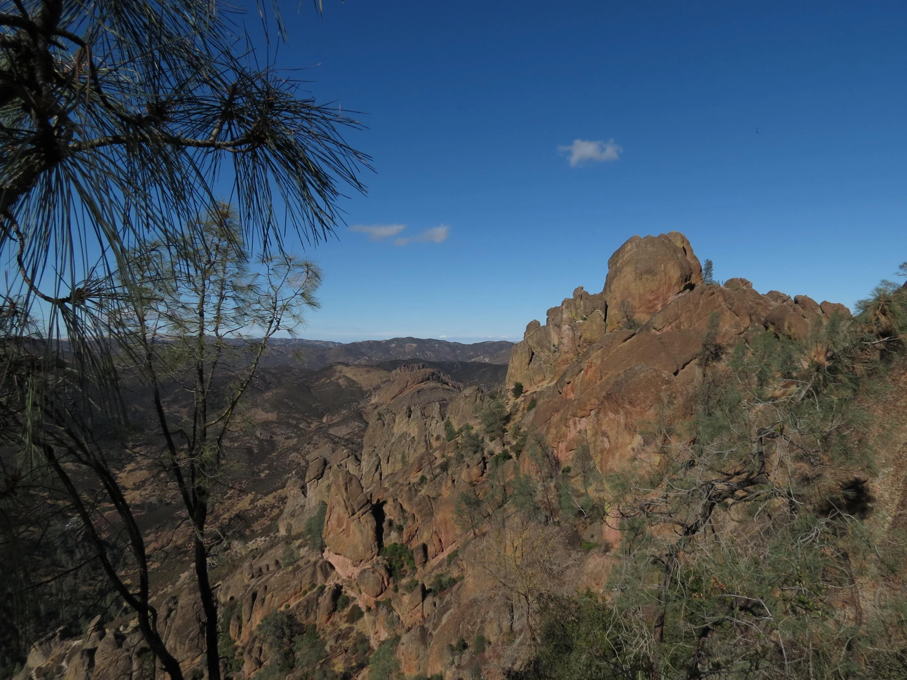
After mapping Biscayne’s underwater neighborhood, the four explorers had reached Pinnacles National Park in California. Jagged rocks stood above hills covered with shrubs. Some rose like towers; others looked like enormous pieces of a castle that nobody had quite finished assembling.
“Geology was feeling dramatic,” Andy said.
Allie opened their notebook. “Our challenge is to discover how rocks from an ancient volcanic field ended up almost two hundred miles from where they formed.”
Ana looked at the drawing. “I suspect we can rule out wheels.”
The family’s grown-up had checked the weather and park information before choosing a short outing from the east side. They would look at nearby formations from the established route and use exhibits and photographs to investigate places they would not reach. This was no expedition up every tower in view.
Augie studied the skyline. “Did somebody carry the volcano?”
“In a way,” said Allie. “But we need to find out what moved, and what did the carrying.”
The rocks were remnants of a volcanic field that formed about twenty-three million years ago near what is now Lancaster in southern California. Pinnacles was much farther northwest today. The towering shapes before them were not an intact volcano standing ready to roll away.
Ana divided the page into three questions: How did the rocks form? How did they move? How did they get these shapes?
“Three mysteries,” Andy said. “One extremely slow road trip.”
Augie added a sandwich to the volcano’s suitcase. Even an incorrect drawing deserved a sensible lunch arrangement.
Then Allie wrote their title: The Traveling Volcano.
“A good title,” Ana said. “As long as we remember that the real traveler was part of the Earth carrying old volcanic rocks.”
2. First make the rocks
At an exhibit, the children studied the beginnings of the volcanic field. Their imaginary traveling castle had started with material from below the surface, not a pile of ready-made towers.
Molten rock underground was called magma. When it reached the surface, flowing molten rock was called lava. Eruptions could also throw out ash and rock fragments. Different eruptions left different deposits.
Andy drew a page full of dots and angular pieces.
“Confetti?” Augie asked.
“Volcanic material,” said Ana. “Definitely not party confetti.”
The Pinnacles volcanic rocks included lava flows and deposits containing fragments from explosive eruptions. Some fragment-rich rock was called volcanic breccia. Its pieces were a clue to a history very different from a smooth stream pebble’s journey.
Allie compared a photograph of angular fragments with the speckled granite they had learned about at Kings Canyon. Both belonged to stories involving molten rock, but they had not formed in exactly the same way.
“Same big subject,” she said. “Different evidence.”
“Like two sandwiches,” Andy replied, “one toasted and one accidentally sat on.”
Ana decided to leave sandwich geology out of the official notes.
The volcanic field had developed through repeated activity. It was not one eruption that produced all the final cliffs, caves and spires in an afternoon. Nor did the age of a volcanic rock tell them the date when a particular boulder fell or a narrow passage opened.
Augie drew three birthday cakes: one for the rocks, one for their journey and one for the shapes they saw now.
“We don’t have the dates for all those candles,” Ana said.
“Then we’ll need questions instead.”
Allie liked that. A useful scientist’s notebook had room for things still to investigate. They could learn the broad sequence without pretending every event came with a neat label.
Their first answer was taking shape: volcanic activity made the material. The wheels still needed an explanation.
3. The ground is the vehicle
Their grown-up put two pieces of paper on the table. Across both sheets, Ana drew one red patch to represent a volcanic field.
“Please don’t erupt on the table,” Andy told it.
Allie slid one sheet past the other. The red patch separated into two offset pieces.
The paper was a simple model of movement along a fault. A fault was a fracture, or zone of fractures, where blocks of rock had moved relative to each other. The San Andreas Fault system lay along the boundary between the Pacific and North American tectonic plates.
“Plates like dinner plates?” Augie asked.
“Enormous moving parts of Earth’s outer shell,” Ana said. “Not crockery.”
The plates included crust and the uppermost rigid mantle. A paper sheet was much thinner, flatter and simpler than a real plate. Still, sliding the sheets helped show something important: a rock could move because the ground containing it moved.
Along this transform boundary, the Pacific Plate moved generally northwest relative to the North American Plate. Movement in the fault system separated parts of the old volcanic field. The rocks now at Pinnacles traveled with their block of ground.
“The ground is the vehicle,” Allie said.
Andy crossed out the wheels. “Much larger vehicle. Terrible parking.”
Augie moved a drawn tree along with the paper. Then he moved a road and a little house.
“If they’re on that piece,” he said, “they go too.”
“Exactly,” said Ana. “The rock doesn’t need to march across the ground by itself.”
Their paper movement took a second. The real history involved millions of years and a complex fault system. The model showed relative sideways movement, not the full history of mountain building, burial, exposure and erosion.
Allie added a label: useful for one idea; not the whole Earth.
Andy gave the paper volcano its suitcase back. “For educational purposes.”
4. Finding the other end of the journey
“How do we know these rocks traveled?” Ana asked.
She would not accept because the volcano looks tired as evidence, although Andy felt that was an excellent observation.
The children studied a map showing Pinnacles and the Neenach volcanic rocks far to the southeast. Geologists had compared their rock types and ages, along with other evidence about the fault system. The separated formations recorded parts of the same ancient volcanic field.
“Like finding related pages from one book in two libraries,” Allie said.
“But not just because both books are red,” Ana added.
Color alone would not establish the connection. Rock textures, composition, age and geological setting all mattered. A geologist needed more than two distant cliffs that happened to look similar in a photograph.
Andy drew two red book covers, then added different words inside them.
“These would fool a very lazy book detective.”
“Fortunately,” said Ana, “we’re practicing.”
The separation was roughly 195 miles, or about 315 kilometers. That was a large distance for the children to imagine, but it represented a very long history, not one enormous leap.
Augie put a tiny arrow between the two places. “The slow lane.”
Their grown-up explained that movement along faults could happen in different ways. Some parts crept gradually; other parts could remain locked while strain accumulated, then slip suddenly in an earthquake. A long-term average did not mean every point moved the same tiny distance every day.
“So we can’t put a little speedometer on our drawing and call it today’s speed,” Allie said.
Ana added another note: past average is not a daily schedule.
No one could use this chapter or the paper model to predict the time of an earthquake. It was a way to understand evidence of movement, not a forecasting machine.
Andy looked at the paper volcano. “There goes its appointment at the train station.”
5. Weather unpacks the luggage
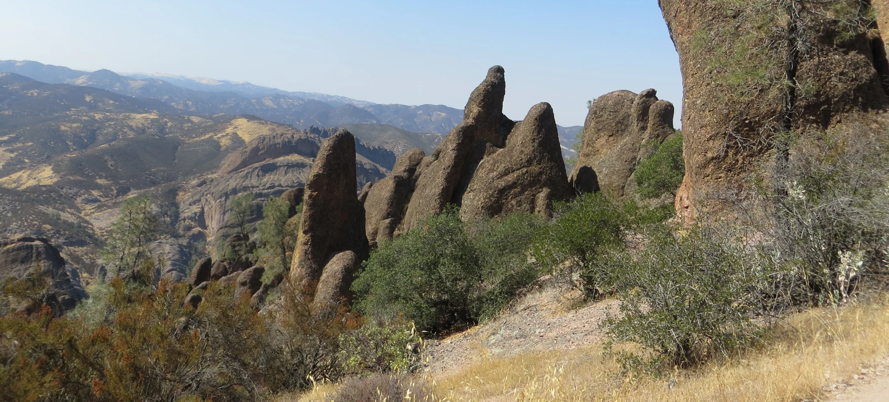
Back outside, the children looked at the formations from their route. Cracks divided some rock faces. Plants filled patches between the bare surfaces. Farther away, spires made uneven lines against the sky.
“The ground delivered the material,” Andy said. “Who unpacked it?”
“Several processes,” Allie replied.
Weathering broke down rock. Erosion removed and carried material away. Water moving through a landscape, changing temperatures, gravity and other processes could work together over time. Different rocks and different parts of a rock mass did not all resist change equally.
Ana remembered the great difference between making granite and carving Kings Canyon. Here, making volcanic rocks, transporting them and shaping the exposed formations were also different jobs.
“The castle didn’t travel here already finished,” she said.
“And nobody unloaded a complete cave,” Andy added.
The rocks had also experienced burial and later exposure during their long history. The children’s three-question page was useful, but the real events overlapped and involved more steps than three little boxes could hold.
Augie drew an unpacking crew: a raindrop, a crack and an arrow pointing downhill.
“Gravity gets another job,” he announced.
“Gravity never seems short of work,” Ana said.
They did not climb onto a loose block to test whether it was ready to move. A rockfall story was something to understand from a safe place, not something to recreate with their bodies underneath it.
Allie looked at the uneven skyline again. A photograph captured a moment in the changing landscape. The cliff was not frozen forever just because it looked solid during their visit.
“First make the material,” she said. “Then follow its movement. Then investigate what reshaped it.”
Andy nodded. “The longest unpacking job in family history.”
Their grown-up glanced at the picnic bag.
“We can complete one unpacking job before lunch gets any later.”
6. A cave built from fallen pieces
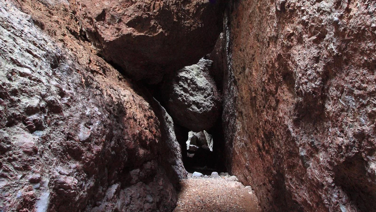
The next part of the investigation happened through a photograph. An enormous boulder was wedged between rock walls, with a dark space beneath it.
Augie leaned closer. “The ceiling fell down and changed its mind halfway.”
“A very memorable description,” Allie said. “Now let’s add the geology.”
Pinnacles had talus caves. Large rocks had fallen into narrow canyons or fractures and become lodged together. Open spaces between and beneath the boulders formed passages. The fallen blocks made a roof over spaces that remained.
Andy drew a narrow gap, then a rock bridging it.
“So the cave didn’t have to be a bubble inside a lava flow?”
“No,” said Ana. “And it didn’t have to form by dissolving a passage through limestone, either.”
They remembered Mammoth Cave’s rainwater investigation. Similar words could hide different processes. A talus cave, a solution cave and a lava tube were all cave spaces, but asking how they formed led to different explanations.
The family was not entering a cave during this outing. Cave access depended on current conditions and park decisions, and their grown-up had chosen to learn from pictures instead. No interesting dark opening was an invitation to scramble inside.
“A photograph is an excellent size of boulder to keep above our heads,” Andy said.
“Especially this one,” Ana agreed.
Water could flow through cave passages, and conditions could change. The existence of a trail in an old photograph did not establish that a route was open or suitable for a family today.
Augie added a question to the drawing: Who uses the dark rooms?
That question would change their investigation. The boulders were not only geological evidence. Their spaces could be habitat.
“We’ve gone from moving rocks to residents again,” Allie said.
Andy opened a new notebook page. “Please tell me the residents aren’t traveling volcanoes.”
7. The bats reserved the room
“Bats,” Ana read.
Augie drew a small door sign: Please do not ring the doorbell.
Pinnacles supported bats that used caves, rock crevices and other sheltered places. Townsend’s big-eared bats used Bear Gulch Cave, including a maternity colony where females raised young. Protecting the animals could mean closing parts of the cave to people.
“The bats reserved the room,” Andy said.
“And we respect the reservation,” Allie replied.
A closure was not a puzzle for visitors to solve by finding a different entrance. It was information about how to care for the place. The children could learn about a habitat without going into every part of it.
Their grown-up asked how this connected to Biscayne.
“Mangrove roots weren’t empty just because we couldn’t see every fish,” Ana said. “A dark cave isn’t empty just because we can’t see its residents.”
The bats at Pinnacles fed primarily on insects and other small invertebrates. A quiet daytime roost belonged to the same food web as a busy night sky.
Andy drew a moon, an insect and a bat. Then he added a sandwich below them.
“Whose food is that?” Allie asked.
“Mine. I’m making the food web accurate.”
They would never touch a bat or reach toward one resting on a wall. Watching respectfully included leaving animals undisturbed, following closures and keeping to established routes.
Augie put a small tick beside his door sign.
“Good neighbors,” he said.
Allie looked back at the map. The same geological history that produced unusual spaces had also helped create places for living things. Protecting a rock formation and protecting its residents could be parts of the same job.
“The cave isn’t an empty room waiting for us,” she wrote. “It is already somebody’s habitat.”
8. A giant bird with a name tag
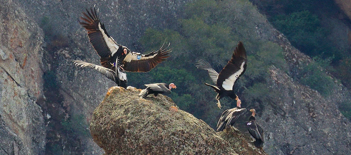
In a park photograph, California condors gathered among the High Peaks. Large dark wings spread above the rocks. Some birds perched while another appeared to be arriving.
“Airplane birds,” Augie whispered.
“Birds are allowed to be big without becoming airplanes,” Ana said.
The children studied the photograph rather than claim they had seen a condor above their trail. A distant dark bird could not be identified confidently just because they hoped it was one.
California condors could soar using rising air, traveling with relatively few wingbeats. They were scavengers, feeding on animals that had already died. That linked them to food and habitat far beyond a single cliff.
“Nature’s cleanup crew,” said Andy. “With magnificent transport.”
Pinnacles participated in condor recovery. Biologists used numbered wing tags and tracking equipment to recognize individuals and study their movements. Monitoring helped people understand the birds’ lives and the dangers they encountered.
Allie drew a number tag beside her bird. “A way to follow one individual’s story.”
“Not a racing number,” Andy said.
“And not permission to approach it,” Ana added.
Condor recovery involved more than releasing birds and hoping for the best. Lead fragments in animal remains could poison scavenging condors. Small pieces of rubbish could also harm them. Scientists, conservation partners and communities worked to reduce these threats.
Augie held up a crumb-sized piece of wrapper from their picnic space.
“Small rubbish still counts.”
Their grown-up helped check the area. Anything sharp or unsafe would be an adult’s responsibility; the children did not need to poke around under rocks to prove they cared.
Andy compared the condor’s movement with the rocks’ journey. Both involved travel, but on very different timescales and for very different reasons.
“Wings for the bird,” he said. “Moving ground for the rocks.”
Augie drew one final label beneath the volcano: No feathers required.
9. Three jobs, one changing landscape
At the end of the outing, the children returned to their three questions.
“How did the rocks form?” Allie asked.
“Volcanic activity,” said Ana. “Different eruptions made different deposits.”
“How did they move?”
“With the ground,” Andy answered. “Movement along the San Andreas Fault system separated parts of the old volcanic field.”
“And how did they get these shapes?”
Augie pointed to his unpacking crew. “Weathering, erosion and gravity had a very long meeting.”
Ana smiled. “Along with the rest of a complicated geological history.”
They had learned to separate the age of a rock from the age of a landscape shape. They had compared related rocks without pretending that matching colors were proof. They had used a model without forgetting what it left out.
And they had found residents in the geological story: bats in sheltered spaces, condors using cliffs and rising air, plants occupying the spaces between rock and soil.
“The rocks’ journey helped make a neighborhood,” Allie said.
“Not an empty castle,” Ana added.
Augie removed the wheels from the original drawing. He left the suitcase and sandwich.
“Still a traveler,” he decided.
Next in their park order was Guadalupe Mountains National Park in Texas. There they would investigate an ancient reef that was now part of a mountain landscape.
Andy stared at the next title. “We just learned about reefs under water. Now we’re putting one in the mountains?”
“We’re following the evidence,” Allie said.
“And bringing lunch,” Augie added.
The spires stood against the sky as the family left. They did not appear to move. Their story, however, reached far beyond the view: an old volcanic field, a journey written in related rocks, and a landscape still changing one event at a time.
Explorer’s notebook
Nine discoveries to keep
- Pinnacles National Park protects remnants of an ancient volcanic field in California.
- The volcanic rocks formed about twenty-three million years ago near present-day Lancaster, far southeast of the park.
- Lava flows and fragment-rich eruption deposits record different parts of the volcanic story.
- Tectonic plates are large, rigid parts of Earth’s outer shell. Faults are fractures or fracture zones where rock blocks move relative to one another.
- Movement along the San Andreas Fault system carried the Pinnacles rocks northwest. Related Neenach rocks remain roughly 195 miles away.
- Geologists combine rock types, ages and geological relationships. Similar-looking cliffs alone do not establish a shared origin.
- Weathering, erosion and gravity helped reshape the rocks. Talus caves formed where fallen boulders left spaces between and beneath them.
- Cave spaces can be important bat habitat. Closures protect animals and respond to changing conditions.
- California condors are scavengers. Recovery work includes tracking individual birds and reducing threats such as lead poisoning and small litter.
Five family adventures
- A paper fault: Place two sheets side by side and draw one volcanic patch across their shared edge. Slide one sheet past the other. Describe how the two parts separate while staying attached to their own sheet. The model shows relative sideways movement; it does not reproduce real plate thickness, earthquakes or the full history of Pinnacles.
- Three jobs, three cards: Make cards labeled “form the rock,” “move the rock” and “reshape the landscape.” Draw an example for each. Explain why the age of volcanic rock is different from the age of a cave opening. Real processes overlap; the cards simplify a much longer story.
- A cave you cannot climb into: With a grown-up, arrange a few soft foam blocks on a table to leave a small gap between them. Look through the gap with a flashlight. Compare this open space with a talus cave. Use only lightweight materials, keep the model small and never build a roof above a person or copy the activity with real boulders.
- Become an evidence detective: Choose two landscape photographs. List similarities and differences, then name three kinds of information you would need before deciding whether their rocks shared an origin. Include at least one thing the pictures cannot tell you.
- A neighborhood care plan: Draw a cliff, a bat roost and a condor. Add one helpful visitor action beside each: stay on the route, respect closures, observe from a distance or secure rubbish. Check your picnic space with a grown-up; leave sharp or unsafe litter for an adult to handle appropriately.
Four questions for the road
- How can rocks travel without sliding across the ground on their own?
- Why would geologists compare more than the color of two rock formations?
- How is a talus cave different from a cave made by dissolving limestone?
- How can protecting a geological place also protect animals that live there?
Eight words for your explorer kit
- Magma: Molten rock below Earth’s surface.
- Lava: Molten rock that has reached the surface.
- Breccia: Rock containing angular fragments of other rock; volcanic breccia is associated with volcanic processes.
- Tectonic plate: A large, rigid part of Earth’s outer shell, including crust and uppermost mantle.
- Fault: A fracture or zone of fractures where rock blocks have moved relative to one another.
- Erosion: The removal and transport of rock or soil material.
- Talus cave: A cave space among fallen rock blocks, often where boulders lodge in a narrow canyon.
- Scavenger: An animal that feeds on the remains of animals that have died.