1. The map needs a bigger map
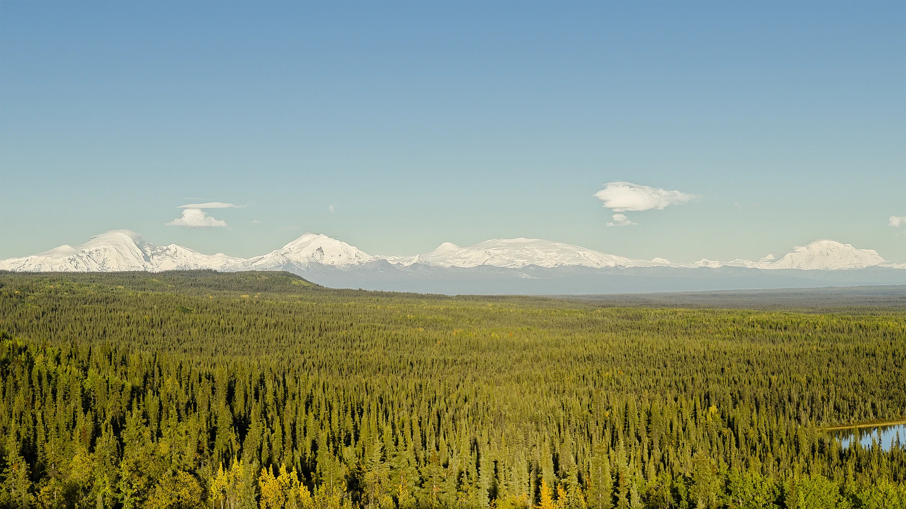
Augie unfolded a map, turned it sideways and unfolded it again.
“I think the park forgot where to stop.”
Andy held down one corner. Ana caught another before it curled over their pencil case. Allie cleared a place for the notebook.
Their next adventure was Wrangell–St. Elias National Park and Preserve in Alaska. It was the largest national park site in the United States, and the combined park and preserve covered more area than Switzerland. Their title, The Park Bigger Than Countries, was a comparison of area, not a claim that every country could fit inside it.
Augie looked at the map’s mountains.
“Did the mountains have a family reunion?”
“Four major ranges meet in this region,” Allie said. “The Wrangell, St. Elias, Chugach and eastern Alaska ranges. We need to learn why so much mountain country is here.”
After Katmai’s salmon connections and volcanic history, the children were ready to look more closely at the forces shaping Alaska. They would combine suitable short observations with park maps, photographs and interpretation. Faraway glaciers, high peaks and historic places could join the investigation without turning their family outing into a mountaineering expedition.
Ana wrote a question across the first page: How do several different processes build and reshape one enormous landscape?
Andy drew an elevator lifting a mountain.
“First theory.”
Augie added a button marked UP.
“Convenient,” Ana said. “Now let’s find an explanation with evidence.”
Allie placed four labels beneath the question: moving plates, volcanoes, ice and rivers. Beside them she left another space for living things and people.
A large map showed where the features were. The next task was finding out how their stories fitted together.
2. A continent assembled from traveling pieces
The children began below the mountains, with Earth’s outer shell. Tectonic plates included the crust and the rigid uppermost mantle beneath it. These huge pieces of solid rock moved slowly relative to one another.
“So the map is riding on something moving,” Andy said.
“Yes,” Allie replied. “But not a loose sheet floating on a worldwide ocean of liquid lava.”
The mantle was mostly solid, though it could deform over long periods. A simple model needed careful labels if it was going to help.
Ana arranged several paper pieces beside a larger sheet marked North America. Each little piece had a different pattern.
Park geology information described terranes: blocks with distinct geological histories. Some rocks now beside one another had formed far apart before plate movements brought them together. Accretion was the joining of such pieces to a growing continental margin.
Augie slid a spotted piece toward a striped one.
“Geological jigsaw puzzle.”
“A puzzle that changed shape while it traveled,” Allie said.
They learned about the Yakutat terrane pressing against and beneath southern Alaska. That collision helped deform and raise parts of the region. Elsewhere along the plate boundary, rock moved downward through subduction, with other motion accommodated along faults.
Andy replaced his mountain elevator with arrows.
“More than one direction. More than one process.”
Ana drew layers bending, then a line where rock had shifted along a break. Folding and faulting were different ways rock could respond to forces. Their paper pieces did not reproduce heat, depth, pressure or millions of years, but they helped organize the ideas.
Augie tried to make the whole model rise at once.
“Does every mountain go up the same way?”
“That is exactly what we should avoid assuming,” Ana said.
They left the question open for the volcano page.
3. Some mountains add their own rock
A snowy mountain photograph did not tell the children whether every peak had formed in the same way. They needed geological information as well as a view.
The Wrangell Mountains included large volcanoes. Repeated eruptions had added volcanic rock over time, helping construct huge mountains. Plate interactions and volcanic activity belonged to a connected regional story, but a volcano was not simply a folded stack of rock with a different name.
Allie drew two small sketches. One showed layers pushed and lifted; another showed successive layers of erupted material building a mountain.
“These are teaching patterns,” she said. “The actual histories can overlap and be much more complicated.”
Andy gave one mountain a construction helmet.
“This one supplies some of its own building material.”
They read about Mount Wrangell, an active volcano. Heat and steam near its summit were reminders of processes below the surface. Active did not mean an eruption was happening every day, and a photograph of a quiet snowy peak could not predict what would happen next.
Augie wrote ACTIVE in small letters under an enormous drawing.
“Tiny word. Very big mountain.”
Ana remembered Novarupta from Katmai. There, they had separated an eruption vent from the collapse of another summit. Here, they also needed names, locations and evidence rather than one generic volcano picture.
The family studied the subject through park information. Their own plans did not include climbing a volcano, approaching summit vents or using old photographs to judge present conditions.
Allie returned to their first question. Plate movements helped assemble and deform the region. Volcanic activity added rock. Neither explanation, by itself, accounted for every peak and valley.
Andy drew a minus sign beside his construction helmet.
“What takes material away?”
Augie opened their Kenai Fjords pages.
“I know someone with sandpaper shoes.”
4. The mountains have icy sculptors
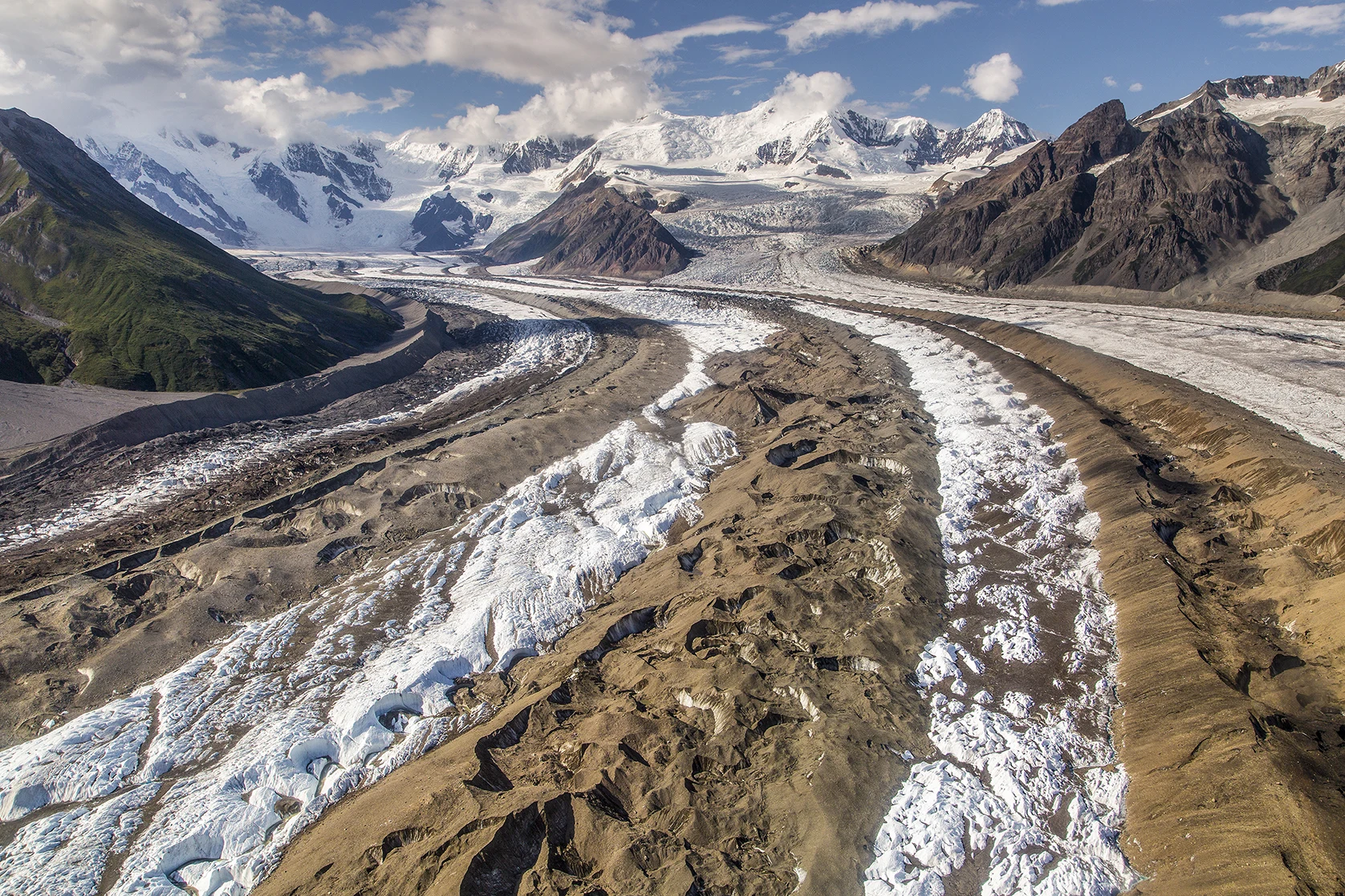
A photograph of Kennicott Glacier spread across the next page. Pale ice flowed between mountain slopes, interrupted by long bands and broad patches of rock debris.
Andy traced a dark stripe without putting his finger on the photograph.
“Travel receipts,” he said, remembering their glacier investigation.
Snow that survived, accumulated and changed into denser ice could become part of a glacier. Under its own weight, glacier ice flowed. It could carry fragments of rock, grind surfaces and help remove blocks from fractured bedrock.
Ana labeled three actions: erode, transport and deposit.
“Building mountains and carving them can happen in the same region,” she said. “The landscape is not waiting for one job to finish before another begins.”
Dark debris bands could show where material gathered as ice streams joined or passed rock outcrops. A debris-covered glacier could look surprisingly unlike a smooth white river. The color alone did not identify all the ice beneath it.
Augie drew an ice river wearing a rocky blanket.
“Disguise mode.”
Their grown-up reminded them that a surface with stones on it was not automatically safe ground. The children were examining a park image, not stepping onto a glacier. Crevasses, unstable margins and other hazards required far more than curiosity and a map.
Allie compared the photograph with a valley drawing from Chapter 54. Glaciers could widen and deepen valleys while moving material farther along the system. What they carved depended on the rock, the ice and a long history of change.
Andy added another arrow, leading from the glacier toward water.
“When the ice melts, its cargo doesn’t just disappear.”
Ana nodded. Their next page would follow a river that seemed unable to choose a single channel.
Augie drew a traffic sign at the edge of his sketch: MANY POSSIBLE ROUTES.
5. A river that keeps rearranging its lanes
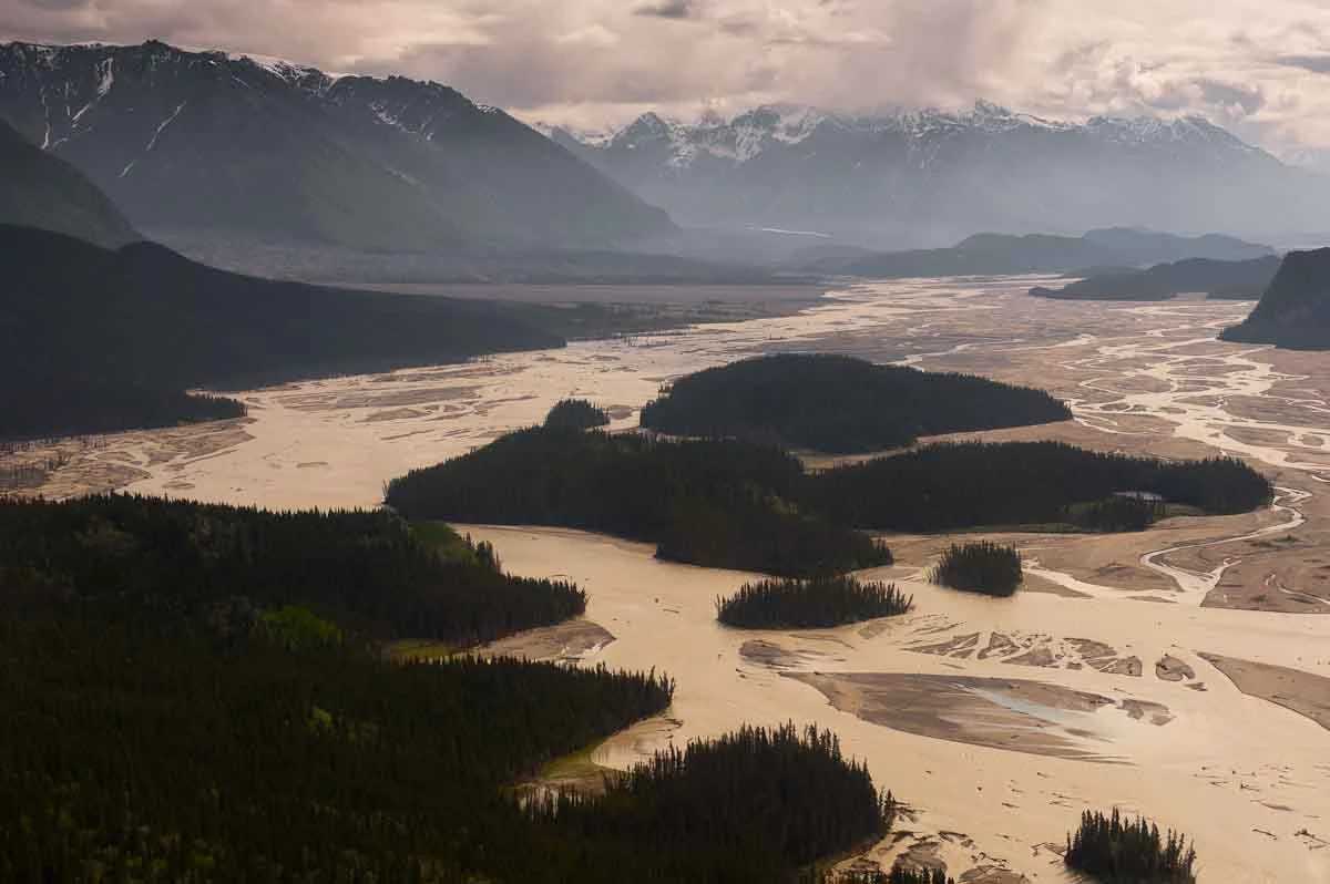
The Chitina River photograph looked like several rivers sharing one wide valley floor. Channels split around gravel bars and joined again farther along.
“Braided,” Allie said.
Augie touched his own hair. “Who braided the river?”
“Flowing water and sediment,” Ana answered. “No hairbrush required.”
Glacial meltwater could carry large sediment loads. When a channel deposited material, a bar could grow and redirect some flow. Changing water levels and the slope and shape of the riverbed also influenced the pattern. Over time, channels could shift, divide and rejoin.
Andy drew arrows around a growing gravel bar.
“A water highway under construction.”
“Useful comparison,” Allie said. “But nobody has promised the lanes will stay in place.”
A shallow-looking branch was not an invitation to wade across. Cold, cloudy water could conceal depth, strong current and an unstable bed. Their family would use established safe viewpoints and park interpretation rather than test a crossing for the notebook.
Ana set the river photograph beside the glacier image. One showed stored and moving ice; the other showed water carrying and sorting material. Their arrows connected the two without pretending they were the same process.
“The sediment has another chapter after leaving the ice.”
Allie added distant destinations to the map. Rivers linked the mountains with lower valleys and, in some drainage systems, the coast. A park boundary did not stop water or the material it carried.
Augie placed a tiny paper bus beside his river drawing, then removed it.
“Bad place for a bus route.”
Andy replaced it with a question: where is material being picked up, and where is it being left behind?
The busy channel pattern had become evidence they could read. The mountains’ story continued well beyond the highest snowy peak.
6. The big landscape has many living neighborhoods
The children’s first map had shown mostly mountains and ice. Now Ana added river corridors, forests, tundra and a coastal margin.
Wrangell–St. Elias included different climates and habitats. Elevation mattered, but so did exposure, moisture, soils and distance from the coast. The real boundaries overlapped; living communities did not arrange themselves in perfectly straight stripes.
“More rooms than our mountain elevator had buttons,” Andy said.
In park wildlife information, the children examined a Dall sheep photograph and descriptions of high-country habitat. The pale animal stood out against darker rock.
“A mountain marshmallow,” Augie said.
“An animal with its own food and shelter needs,” Allie added. “We should explain more than its color.”
The children did not claim a sheep sighting during their own outing. A white dot on a distant slope could be many things without a clear view and other evidence. Studying a reliable photograph let them look closely without following wildlife onto steep ground.
Ana drew plants beside the sheep rather than leaving it alone in a field of rocks.
“Even an animal we associate with cliffs belongs to a food web.”
Andy remembered Katmai’s salmon. Different landscapes had different connections, but the habit of asking about food, movement and habitat still helped.
A large protected landscape could include space for seasonal movement and connections between habitats. That did not make it free of change. Weather, climate, disturbance and human activities could still influence its living communities.
Allie added a note beside the word vast: size creates possibilities; it does not remove every pressure.
Augie gave his paper sheep a very small map.
“We should leave its real directions to the sheep.”
They kept the map in the notebook and the real landscape undisturbed.
7. A homeland is not an empty space
The family read about the Ahtna, Upper Tanana, Eyak and Tlingit peoples and their continuing relationships with this region. The names represented distinct communities and histories, not four interchangeable labels for a single culture.
Allie wrote each name carefully beside a larger question: whose knowledge helps us understand this place?
People had traveled, traded, harvested food and made homes in these lands across many generations. The region’s rivers, mountains and ice were part of lived experience and knowledge, not simply scenery on a visitor map.
Ana found park information describing Native copper worked into tools and ornaments long before the industrial mining story they would study next.
“So copper didn’t become important only when a company arrived,” she said.
Andy drew two separate timeline entries rather than pushing everything into the same box. One concerned long Native relationships with materials and place; another would concern later industrial mining. They connected, but they were not the same history.
Living communities continued to use and care about these lands. Oral histories, traditional knowledge and people’s own accounts offered perspectives a short family visit could not replace.
Augie looked at the broad spaces between symbols on their map.
“They aren’t blank?”
“They may be blank on our printed page,” Allie said. “That doesn’t mean nobody knows them or that they have no names or stories.”
The children left room for questions instead of inventing a traditional tale. They also understood why archaeological places, historic objects and private lands deserved respect.
Ana added a new label beneath their geological arrows: a cultural landscape too.
Their investigation had become larger in a different way. They were not adding more square miles. They were learning to notice meanings that a measurement of area could never contain.
8. Copper connects the mountains to the world
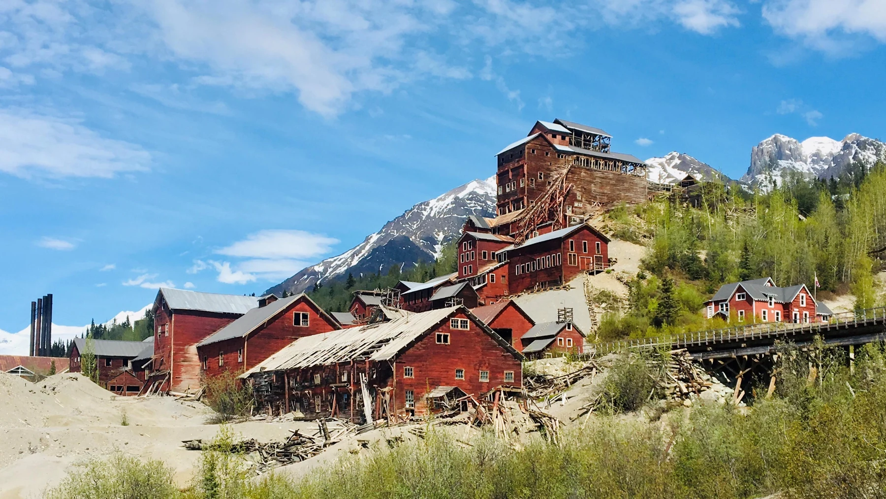
Red buildings at Kennecott filled the next photograph. Against the mountain setting, the tall mill looked almost like a stack of giant building blocks.
Augie counted windows until he lost his place.
“The building needs its own map.”
Kennecott’s mines and mill town had different jobs. Ore came from mines in the mountains; the mill processed it to concentrate valuable material. Rail and shipping connections carried the product toward distant industry.
Allie drew a chain: ore, mine, mill, transport and users elsewhere.
“Remote doesn’t mean disconnected.”
People lived and worked in the company town. Historic buildings represented labor, families, technology, business decisions and changing economies, not only an impressive machine for obtaining copper.
Andy added a school beside the mill drawing. Ana added a question about the people whose work kept the operation going.
The children studied these subjects through photographs and interpretation. A picture did not establish which building was open, where it was safe to enter or what restoration work was happening. Their family would follow current access guidance and leave structures and objects untouched.
Allie noticed the spelling: Kennecott for the historic mining site, Kennicott in the glacier name they had studied earlier.
“Two similar words on nearby pages. Our labels need attention.”
Augie put a large E beside the mill and an I beside the glacier.
“Emergency spelling equipment.”
The mine story also changed their first picture of geology. Rocks were not only ingredients in mountain-building. People recognized, valued, worked and traded their materials, changing landscapes and lives in the process.
Ana drew an arrow back toward the Native copper note.
“We need the longer timeline as well as the industrial one.”
The red mill photograph belonged beside the glacier and river images. Together they showed different kinds of movement and connection through the same broad region.
9. Four small explorers, several very big processes
At the end of the investigation, Andy returned to his first mountain drawing. The elevator button still said UP.
“Helpful first joke,” he said. “Not a complete explanation.”
Allie asked each child to replace part of it with something they had learned.
Ana chose traveling pieces. “Plate movement brought together rocks with different histories. Collision, folding and faulting helped deform and raise the region.”
Andy chose construction. “Volcanoes added rock in the Wrangell Mountains. Not every high peak had exactly the same beginning.”
Augie chose the sculptors. “Ice carries rock tools. Rivers carry the pieces farther and rearrange their lanes.”
Allie added time. These processes worked over different timescales, could overlap and could leave evidence in rock, ice, sediment and landscape shape. A single photograph could help them ask questions without explaining every stage by itself.
Their question had begun with enormous scenery. Their answer included moving plates, volcanic construction, glacial erosion, rivers, habitats and people’s continuing relationships with the land.
“The biggest map still needs more than one kind of label,” Ana said.
Augie folded his paper sheep’s map into the notebook.
“And maybe a smaller pair of hands.”
The title no longer seemed like a competition between parks and countries. It was an invitation to think about scale: the area of a protected place, the height and depth of its features, the length of its histories and the limits of one family’s visit.
Allie wrote their next destination: North Cascades National Park, where moving air would help explain wet forests, snowy heights and drier country.
Andy held the notebook closed while Augie folded the large map.
“This one fits,” Augie announced.
The landscape outside remained much bigger than the page. The children were pleased to have found a better question than whether it could all fit inside their drawing.
Explorer’s notebook
Nine discoveries to keep
- Wrangell–St. Elias National Park and Preserve is a vast protected area where four major mountain ranges meet.
- Tectonic plates include crust and the rigid uppermost mantle; they are not loose continents floating on liquid lava.
- Terranes are blocks with distinct geological histories that can be brought together through plate motion and accretion.
- Collision, folding and faulting help reshape and raise parts of southern Alaska.
- Volcanic activity also adds rock; Mount Wrangell is an active volcano, not a promise of an eruption during a visit.
- Glaciers erode, carry material and leave deposits while flowing under their own weight.
- Sediment, changing flow and riverbed conditions help create braided channels that can shift over time.
- Habitats vary with climate, elevation and local conditions, supporting many living communities.
- Ahtna, Upper Tanana, Eyak and Tlingit connections continue today; Kennecott’s industrial history is one part of a longer human story.
Five family adventures
- Make a traveling-piece collage. Draw different rock patterns on several pieces of scrap paper. Move them toward a larger continent sheet and label which pieces join. Add arrows for relative movement. Explain that the model shows the idea of accretion but does not reproduce real rock deformation, depth, heat or the actual geography of Alaska.
- Compare building and carving. Fold one strip of paper gently to model compressed layers. Stack small paper shapes in another place to represent material added by eruptions. On a third drawing, shade a valley where a glacier removes and transports material. Give each process a different label and explain why one model cannot account for every mountain.
- Follow a braided-river puzzle. Draw a wide gravel bed with several connected channels and bars. In a second drawing, enlarge one bar and show how some flow could take another route. Label deposition and changing flow. This is a paper explanation, not a real river-crossing plan; never test channels by wading into glacial water.
- Read four photographs as evidence. Choose a mountain, glacier, braided river and historic mill image from this chapter. Write one thing visibly present, one explanation supported by the story, and one thing the photograph cannot establish. Keep dates and sources with any images you compare. Do not infer current access, wildlife sightings or safe ground from a photograph.
- Build a landscape story map. Draw a mountain-to-valley scene with places for ice, water, plants, wildlife and people. Add an older Native copper-history note and a separate Kennecott industrial-history note using park interpretation. Include a present-day community connection. Leave a question box for what you still want to learn, rather than inventing a traditional account or eyewitness quotation.
Four questions for the road
- Why might neighboring rocks have different origins before becoming part of the same Alaska landscape?
- How can mountains be built and worn away in the same region at the same time?
- Why do dark debris bands on a glacier and shifting river channels belong in one connected investigation?
- What important parts of a place’s story are missing from a map that shows only mountains and an area measurement?
Eight words for your explorer kit
- Tectonic plate: A moving piece of Earth’s outer shell, including crust and rigid uppermost mantle.
- Terrane: A block of crustal rocks with a geological history distinct from neighboring blocks.
- Accretion: Addition of geological material, such as a terrane joining a continental margin.
- Subduction: Movement of one tectonic plate beneath another into the mantle.
- Fault: A break or zone of breaks in rock along which movement has occurred.
- Moraine: An accumulation or band of debris associated with a glacier.
- Braided river: A river with multiple dividing and rejoining channels separated by sediment bars.
- Ore: Naturally occurring material from which a useful mineral or metal can be extracted economically.